Bitung
Bitung | |
|---|---|
| City of Bitung Kota Bitung | |
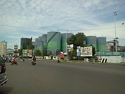 Streets of Bitung | |
|
Seal | |
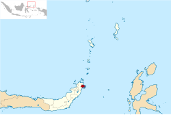 Location within North Sulawesi | |
| Coordinates: 1°26′50″N 125°11′52″E / 1.44722°N 125.19778°ECoordinates: 1°26′50″N 125°11′52″E / 1.44722°N 125.19778°E | |
| Country | |
| Region | Sulawesi |
| Province | |
| Established | 10 April 1975 as Administrative City of Bitung 15 August 1990 as Bitung City |
| Government | |
| • Mayor | Max Lomban |
| • Vice Mayor | Maurits Mantri |
| Area | |
| • Total | 313.51 km2 (121.05 sq mi) |
| Population | |
| • Total | 225,134 |
| • Density | 720/km2 (1,900/sq mi) |
| Time zone | UTC+8 (Indonesia Central Time) |
| Postcodes | 9xxxx |
| Area code | (+62) 438 |
| Vehicle registration | DB |
| Website | bitungkota.go.id |


Bitung is a city on the northern coast of the island of Sulawesi in Indonesia. It is in the province of North Sulawesi, and faces Lembeh Island (which forms two districts of the city) and the Lembeh Strait, which is known for its colourful marine life, in particular sea slugs. Bitung has a population of 187,932 at the 2010 Census, making it the second most populated city in the province after the capital Manado,[1] rising to 225,134 at the 2020 Census.[3]
At present large numbers of development projects undergoing centering around the city, which include the SEZ, Manado-Bitung toll road, Bitung International Ocean Going Ship Port, and the Makasar-Bitung rail track, which will automatically make the city a gateway to the Pacific region.[4]
Administrative divisions[]
The city is divided into eight districts (kecamatan), tabulated below with their areas and their populations at the 2010 Census[5] and the 2020 Census.[6] The table also includes the number of administrative villages (urban kelurahan) in each district.
| Name | Area in km2 |
Pop'n Census 2010 |
Pop'n Census 2020 |
Number of villages |
|---|---|---|---|---|
| Madidir (a) | 20.83 | 33,482 | 36,323 | 8 |
| Matuari (b) | 33.96 | 27,180 | 40,496 | 8 |
| Girian | 5.17 | 27,862 | 38,074 | 7 |
| Lembeh Selatan (c) (South Lembeh) |
25.53 | 9,120 | 10,665 | 7 |
| Lembeh Utara (North Lembeh) |
27.66 | 8,509 | 9,525 | 10 |
| Aertembaga (d) | 33.09 | 28,262 | 29,994 | 10 |
| Maesa | 9.70 | 36,007 | 39,681 | 8 |
| Ranowulu (e) | 157.57 | 17,230 | 20,376 | 11 |
| Totals | 313.51 | 187,932 | 225,134 | 69 |
Notes: (a) formerly Bitung Tengah (Central Bitung). (b) formerly Bitung Barat (West Bitung). (c) formerly Bitung Selatan (South Bitung); the district includes 15 offshore islands. (d) formerly Bitung Timur (East Bitung).
(e) formerly Bitung Utara (North Bitung); the district includes offshore island of Pulau Powteng.
Nature Reserve[]
Tangkoko Batuangus Nature Reserve is two hours' drive away from Manado, and one hour from Bitung. Tarsius spectrum can be found easily in the Nature Reserve.[7]
Economy[]
Bitung Special Economic Zone (SEZ)[]
Bitung was named as one of the country's Special Economic Zones in 2014. Priority sectors in the area are logistics, herbal pharmacy, fish processing and coconut processing. Based on Government Regulation No.32/2014 on Bitung SEZ, it will occupy an area of 534 hectares. The SEZ is divided into three zones, namely industrial zone, logistics zone and Export Processing Zone.[8]
Transport[]
Manado-Bitung Toll Road[]
On 16 January 2014 local authorities passed responsibility to acquire land for the Manado–Bitung Toll Road to the Public Works Ministry, although the initiation of works after the formality would take some time.[9] The construction of the 39.9-km toll road is expected to cost Rp 6.7 trillion (US$ 503 million), and the Indonesian Government expects it to be completed by late 2018 and operational on 2019.[10]
Davao-Bitung Roll-On Roll-Off Ferry Service[]

On 28 April 2017, Philippines President Rodrigo Duterte and Indonesia President Joko Widodo inaugurated the Davao-Bitung Roll-on Roll-Off Ferry Service that will allow journey time of just 3 days between two cities. The original shipping route from Davao City in Mindanao, Philippines took up to 5 weeks because ships first have to sail northwards to Manila, passing through South China Sea and Malaysia waters before it reaches various ports in Indonesia. Under the program, there are 5 to 10 companies who will use the initial voyage of the Cebu-based Asia Marine Transport Corp.’s M/V Super Shuttle RORO 12 with a 500-TEU capacity. Among the goods to be traded include animal feeds, aqua products, charcoal, coffee beans, construction materials, copra, feed ingredients, fertilizers, food and beverages, fresh fruits, ice cream products, meats, peanuts, poultry (halal), soya, sugar, and synthetics.[11][12][13][14] By 2019, however, the route had ceased operations due to a lack of demand caused by similarities in commodities produced by the two cities.[15]
Climate[]
Bitung has a tropical rainforest climate (Af) with heavy to very heavy rainfall year-round.
| hideClimate data for Bitung | |||||||||||||
|---|---|---|---|---|---|---|---|---|---|---|---|---|---|
| Month | Jan | Feb | Mar | Apr | May | Jun | Jul | Aug | Sep | Oct | Nov | Dec | Year |
| Average high °C (°F) | 29.4 (84.9) |
29.5 (85.1) |
29.7 (85.5) |
30.7 (87.3) |
30.8 (87.4) |
30.9 (87.6) |
30.9 (87.6) |
31.5 (88.7) |
31.6 (88.9) |
31.6 (88.9) |
30.8 (87.4) |
29.9 (85.8) |
30.6 (87.1) |
| Daily mean °C (°F) | 25.8 (78.4) |
25.9 (78.6) |
26.1 (79.0) |
26.5 (79.7) |
26.7 (80.1) |
26.7 (80.1) |
26.6 (79.9) |
26.8 (80.2) |
26.7 (80.1) |
26.8 (80.2) |
26.6 (79.9) |
26.2 (79.2) |
26.5 (79.6) |
| Average low °C (°F) | 22.3 (72.1) |
22.3 (72.1) |
22.5 (72.5) |
22.4 (72.3) |
22.7 (72.9) |
22.5 (72.5) |
22.3 (72.1) |
22.2 (72.0) |
21.9 (71.4) |
22.1 (71.8) |
22.5 (72.5) |
22.6 (72.7) |
22.4 (72.2) |
| Average rainfall mm (inches) | 387 (15.2) |
319 (12.6) |
277 (10.9) |
249 (9.8) |
233 (9.2) |
203 (8.0) |
155 (6.1) |
124 (4.9) |
137 (5.4) |
165 (6.5) |
263 (10.4) |
331 (13.0) |
2,843 (112) |
| Source: Climate-Data.org[16] | |||||||||||||
References[]
- ^ Jump up to: a b c "Jumlah Penduduk menurut Kabupaten/Kota di Provinsi Sulawesi Utara 2000 - 2016". Badan Pusat Statistik Provinsi Sulawesi Utara (in Indonesian). Statistics Indonesia. Archived from the original on 6 January 2017. Retrieved 9 August 2017.
- ^ Badan Pusat Statistik, Jakarta, 2021.
- ^ Badan Pusat Statistik, Jakarta, 2021.
- ^ "Training of manpower necessary for development of Bitung SEZ". Antara News. Retrieved 24 December 2018.
- ^ Biro Pusat Statistik, Jakarta, 2011.
- ^ Badan Pusat Statistik, Jakarta, 2021.
- ^ "Taman Nasional Tangkoko". Retrieved May 27, 2013.
- ^ "Chinese Company Promises Better Development in Bitung". Tempo. Retrieved 24 December 2018.
- ^ "Jalan Tol Manado Bitung di Launching". 16 January 2014.
- ^ Sugianto, Danang (2 May 2017). "Proyek Jalan Tol Manado-Bitung Habiskan Dana Hingga Rp 6,7 T" (in Indonesian). Detik. Retrieved 9 August 2017.
- ^ "Jokowi, Duterte Open New Shipping Line Between Davao City and Bitung".
- ^ "Sah, Kapal Ro-Ro Davao-Bitung Mulai Beroperasi 30 April". 28 April 2017.
- ^ "Soon: Shorter shipping route between PH, Indonesia".
- ^ "Davao-GenSan-Bitung RORO route to decongest ports in Manila". 28 April 2017.
- ^ "Pengoperasian Ulang Rute Bitung--Davao Masih Tunggu Insentif". Bisnis.com (in Indonesian). 18 July 2019. Retrieved 5 March 2021.
- ^ "Climate: Bitung". Climate-Data.org. Retrieved 22 November 2020.
Media[]
- Port cities and towns in Indonesia
- Populated places in North Sulawesi
- Cities in Indonesia
- 1990 establishments in Indonesia