Kotamobagu
Kotamobagu | |
|---|---|
 Coat of arms | |
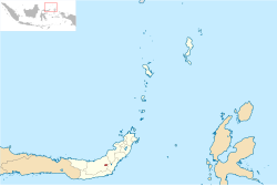 Location within North Sulawesi | |
| Coordinates: 0°44′N 124°19′E / 0.733°N 124.317°ECoordinates: 0°44′N 124°19′E / 0.733°N 124.317°E | |
| Country | |
| Province | |
| Government | |
| • Mayor | |
| • Vice Mayor | |
| Area | |
| • Total | 108.89 km2 (42.04 sq mi) |
| Population (2020 Census) | |
| • Total | 123,722 |
| • Density | 1,100/km2 (2,900/sq mi) |
| [1] | |
| Time zone | UTC+8 (Indonesia Central Time) |
| Area code | (+62) 434 |
| Website | kotamobagukota |


Kotamobagu is a city in North Sulawesi, Indonesia. It is the principal centre of the southern part of the province - the Bolaang Mongonow region, which is projected by the Indonesian government to be separated from the rest of North Sulawesi and formed into a separate province. The city covers an area of 108.89 km2, and had a population of 107,459 at the 2010 Census,[2] rising to 123,722 at the 2020 Census.[3]
Administrative districts[]
The city is divided into four districts (kecamatan) tabulated below with their areas and their population as at the 2010 Census[4] and the 2020 Census.[5] The table also includes the location of the district centres, the number of administrative villages (urban kelurahan) in each district, and its postal codes.
| Name | Area in km2 |
Pop'n Census 2010 |
Pop'n Census 2020 |
Admin centre |
Number of villages |
Post codes |
|---|---|---|---|---|---|---|
| Kotamobagu Selatan (South Kotamobagu) |
62.97 | 28,030 | 33,353 | Poyowa Besar | 9 | 95717 |
| Kotamobagu Timur (East Kotamobagu) |
23.69 | 26,355 | 30,904 | Kotobangon | 10 | 95712-95719 |
| Kotamobagu Barat (West Kotamobagu) |
12.20 | 37,678 | 41,843 | Mongkonai Barat | 6 | 95711-95716 |
| Kotamobagu Utara (North Kotamobagu) |
10.04 | 15,396 | 17,622 | Bilalang 1 | 8 | 95713-95714 |
| Totals | 108.89 | 107,459 | 123,722 | 33 |
Autonomy[]
As an autonomous city, in 2011 Kotamobagu was judged the best autonomous area from among 57 autonomous areas which have been formed by central government since 2007.[6]
Climate[]
Kotamobagu has a tropical rainforest climate (Af) with moderate rainfall in August and September and heavy rainfall in the remaining months.
| hideClimate data for Kotamobagu | |||||||||||||
|---|---|---|---|---|---|---|---|---|---|---|---|---|---|
| Month | Jan | Feb | Mar | Apr | May | Jun | Jul | Aug | Sep | Oct | Nov | Dec | Year |
| Average high °C (°F) | 28.8 (83.8) |
28.8 (83.8) |
29.1 (84.4) |
29.8 (85.6) |
29.7 (85.5) |
29.6 (85.3) |
29.4 (84.9) |
30.0 (86.0) |
30.4 (86.7) |
30.5 (86.9) |
30.1 (86.2) |
29.3 (84.7) |
29.6 (85.3) |
| Daily mean °C (°F) | 25.0 (77.0) |
24.9 (76.8) |
25.2 (77.4) |
25.6 (78.1) |
25.7 (78.3) |
25.6 (78.1) |
25.3 (77.5) |
25.5 (77.9) |
25.5 (77.9) |
25.6 (78.1) |
25.7 (78.3) |
25.3 (77.5) |
25.4 (77.7) |
| Average low °C (°F) | 21.2 (70.2) |
21.1 (70.0) |
21.4 (70.5) |
21.4 (70.5) |
21.8 (71.2) |
21.6 (70.9) |
21.3 (70.3) |
21.1 (70.0) |
20.7 (69.3) |
20.8 (69.4) |
21.4 (70.5) |
21.4 (70.5) |
21.3 (70.3) |
| Average rainfall mm (inches) | 216 (8.5) |
179 (7.0) |
186 (7.3) |
201 (7.9) |
211 (8.3) |
174 (6.9) |
134 (5.3) |
93 (3.7) |
94 (3.7) |
136 (5.4) |
204 (8.0) |
197 (7.8) |
2,025 (79.8) |
| Source: Climate-Data.org[7] | |||||||||||||
References[]
- ^ Badan Pusat Statistik, Jakarta, 2021.
- ^ (in Indonesian) Jumlah Penduduk Sulawesi Utara Tahun 2010 Archived 2011-11-28 at the Wayback Machine
- ^ Badan Pusat Statistik, Jakarta, 2021.
- ^ Biro Pusat Statistik, Jakarta, 2011.
- ^ Badan Pusat Statistik, Jakarta, 2020.
- ^ "Kotamobagu Daerah Otonom Terbaik". March 22, 2012.
- ^ "Climate: Kotamobagu". Climate-Data.org. Retrieved 22 November 2020.
External links[]
| show Authority control |
|---|
This North Sulawesi location article is a stub. You can help Wikipedia by . |
- Cities in Indonesia
- Sulawesi geography stubs