Bleiswijk
This article includes a list of references, related reading or external links, but its sources remain unclear because it lacks inline citations. (March 2013) |
Bleiswijk | |
|---|---|
Village | |
 Nederlands Hervormde Kerk | |
 Flag  Seal | |
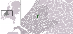 Location in South Holland | |
 Bleiswijk Location within the Netherlands | |
| Coordinates: Coordinates: 52°01′N 4°32′E / 52.01°N 4.54°E | |
| Country | |
| Province | |
| Municipality | |
| Area | |
| • Total | 21.96 km2 (8.48 sq mi) |
| • Land | 21.13 km2 (8.16 sq mi) |
| • Water | 0.84 km2 (0.32 sq mi) |
| Population (January 2020) | |
| • Total | 10,895 |
| • Density | 500/km2 (1,300/sq mi) |
| Time zone | UTC+1 (CET) |
| • Summer (DST) | UTC+2 (CEST) |
| Postal code | 2665 |
| Area code(s) | 010 |
| Major roads | |

Bleiswijk (Dutch: [ˈblɛisʋɛik] (![]() listen)) is a town and former municipality in the western Netherlands, in the province of South Holland.
listen)) is a town and former municipality in the western Netherlands, in the province of South Holland.
Demographics[]
The municipality had a population of 10,222 in 2006, and covered an area of 21.96 km² (8.48 mile²) of which 0.83 km² (0.32 mile²) is water. On 1 January 2007, the town was merged with neighbouring towns Bergschenhoek and Berkel en Rodenrijs to form the new municipality Lansingerland.
According to the January 2020 census, its population was 10,895.[1]
References[]
- ^ "Kerncijfers wijken en buurten 2020" (in Dutch). CBS. Retrieved November 13, 2020.
External links[]
| Wikimedia Commons has media related to Bleiswijk. |
| show Authority control |
|---|
This South Holland location article is a stub. You can help Wikipedia by . |
Categories:
- Populated places in South Holland
- Former municipalities of South Holland
- Lansingerland
- South Holland geography stubs