Bluff, Alaska
Bluff
Iġukuchiq | |
|---|---|
Ghost Town | |
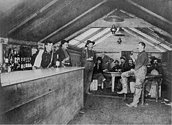 Road House Saloon, Bluff City, Alaska, photograph by Beverly Bennett Dobbs | |
 Bluff Location in Alaska | |
| Coordinates: 64°34′22″N 163°45′15″W / 64.57278°N 163.75417°W | |
| Country | United States |
| State | Alaska |
| Borough | |
| Elevation | 59 ft (18 m) |
| Time zone | UTC-9 (Alaska (AKST)) |
| • Summer (DST) | UTC-8 (AKDT) |
| ZIP code | 99762 |
| Area code | 907 |
| FIPS code | 02-08445 |
| GNIS feature ID | 1399220 |

Bluff, also known as Agookauchuk (Iġukuchiq in Iñupiaq), was a 20th-century mining town in Nome Census Area, Alaska. It was built at the mouth of Daniels Creek on the north shore of Norton Sound on the Seward Peninsula in the summer of 1900, as a result of the Nome Gold Rush.[1][2] The town was located 55 miles (89 km) southeast of Nome.[3] The settlement was served by a post office for eighteen years, from 1901 to 1919.[4]
Coordinates: 64°34′22″N 163°45′15″W / 64.57278°N 163.75417°W
Demographics[]
| Historical population | |||
|---|---|---|---|
| Census | Pop. | %± | |
| 1940 | 19 | — | |
| U.S. Decennial Census[5] | |||
Bluff appeared once on the 1940 U.S. Census as an unincorporated village.[6] It has not appeared since. A few buildings are still extant at the townsite.[7]
References[]
- ^ "Domestic Names | U.S. Geological Survey". Usgs.gov. Retrieved 31 January 2022.
- ^ "Geological Survey Professional Paper". U.S. Government Printing Office. 31 January 1949. p. 49. Retrieved 31 January 2022 – via Google Books.
- ^ "Bluff, Alaska". Alaskagoldrush.info. Retrieved 17 January 2015.
- ^ "Bluff". Geographic Names Information System. United States Geological Survey. Retrieved 17 January 2015.
- ^ "U.S. Decennial Census". Census.gov. Retrieved June 6, 2013.
- ^ "Alaska" (PDF). 2.census.gov. Retrieved January 31, 2022.
- ^ "64°34'20.5"N 163°45'26.5"W · Nome, AK". Google.com. Retrieved 31 January 2022.
Municipalities and communities of Nome Census Area, Alaska, United States | ||
|---|---|---|
| Cities |  | |
| CDP | ||
| Unincorporated communities | ||
| Ghost towns | ||
| ||
This article about a location in the Nome Census Area, Alaska is a stub. You can help Wikipedia by . |
- Mining communities in Alaska
- Unincorporated communities in Nome Census Area, Alaska
- Nome Census Area, Alaska geography stubs