Blumengard Colony, South Dakota
Blumengard Colony, South Dakota | |
|---|---|
 Blumengard Colony | |
| Coordinates: 45°14′38″N 99°10′6″W / 45.24389°N 99.16833°WCoordinates: 45°14′38″N 99°10′6″W / 45.24389°N 99.16833°W | |
| Country | United States |
| State | South Dakota |
| County | Faulk |
| Area | |
| • Total | 0.23 sq mi (0.60 km2) |
| • Land | 0.23 sq mi (0.60 km2) |
| • Water | 0.0 sq mi (0.0 km2) |
| Elevation | 1,605 ft (489 m) |
| Time zone | UTC-6 (Central (CST)) |
| • Summer (DST) | UTC-5 (CDT) |
| ZIP Code | 57438 (Faulkton) |
| Area code(s) | 605 |
| FIPS code | 46-06140 |
| GNIS feature ID | 2813022[2] |


Blumengard Colony is a Hutterite colony[3] and census-designated place (CDP) in Faulk County, South Dakota, United States. It was first listed as a CDP prior to the 2020 census.[2]
It is on the northern edge of the county, bordered to the north by Edmunds County. It is 17 miles (27 km) north of Faulkton, the county seat, and 16 miles (26 km) northwest of Cresbard. Thunderbird Colony is 9 miles (14 km) by road to the southwest.
References[]
- ^ "2020 U.S. Gazetteer Files – South Dakota". United States Census Bureau. Retrieved September 15, 2021.
- ^ a b "Blumengard Colony Census Designated Place". Geographic Names Information System. United States Geological Survey.
- ^ Friesen, Bert (May 2021). "Blumengard Hutterite Colony (Faulkton, South Dakota, USA)". Global Anabaptist Mennonite Encyclopedia Online. Retrieved September 15, 2021.
Municipalities and communities of Faulk County, South Dakota, United States | ||
|---|---|---|
| City | 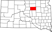 | |
| Towns | ||
| CDPs | ||
| Unincorporated communities | ||
| ||
This South Dakota state location article is a stub. You can help Wikipedia by . |
Categories:
- Census-designated places in Faulk County, South Dakota
- Census-designated places in South Dakota
- Hutterite communities
- South Dakota geography stubs