Bobowo
Bobowo | |
|---|---|
Village | |
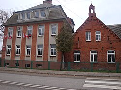 Primary school in Bobowo | |
 Bobowo | |
| Coordinates: 53°53′3″N 18°33′22″E / 53.88417°N 18.55611°E | |
| Country | |
| Voivodeship | Pomeranian |
| County | Starogard |
| Gmina | Bobowo |
| Population | 1,271 |
| Time zone | UTC+1 (CET) |
| • Summer (DST) | UTC+2 (CEST) |


Bobowo ([bɔˈbɔvɔ] (German: Bobau, Kashubian: Bòbòwò) is a village in Starogard County, Pomeranian Voivodeship, in northern Poland. It is the seat of the gmina (administrative district) called Gmina Bobowo.[1] It lies approximately 10 kilometres (6 mi) south of Starogard Gdański and 54 km (34 mi) south of the regional capital Gdańsk. It is located within the ethnocultural region of Kociewie in the historic region of Pomerania.
The village has a population of 1,271.
The landmark of Bobowo is the Saint Adalbert church.
History[]

Bobowo was a royal village of the Polish Crown, administratively located in the Tczew County in the Pomeranian Voivodeship.[2] It was annexed by Prussia in the First Partition of Poland in 1772. Despite the partitions, the village remained a local Polish center in the 19th century, there were Polish organizations in Bobowo, including a bank founded in 1866.[3] After Poland regained independence in 1918, the village was restored to Poland.
During the German occupation of Poland (World War II), in October 1939, the Germans carried out a massacre of seven Poles in the village.[4] Teachers from Bobowo were among Polish teachers murdered by the Germans on October 20, 1939 in the Szpęgawski Forest as part of the Intelligenzaktion.[5] Dozens of Polish families were expelled to the General Government, deported for forced labour to Germany or assigned as forced laborers to new German colonists.[6]
References[]
- ^ "Central Statistical Office (GUS) - TERYT (National Register of Territorial Land Apportionment Journal)" (in Polish). 2008-06-01.
- ^ Marian Biskup, Andrzej Tomczak, Mapy województwa pomorskiego w drugiej połowie XVI w., Toruń, 1955, p. 110 (in Polish)
- ^ Słownik geograficzny Królestwa Polskiego i innych krajów słowiańskich, Tom I, Warszawa, 1880, p. 257-258 (in Polish)
- ^ Maria Wardzyńska, Był rok 1939. Operacja niemieckiej policji bezpieczeństwa w Polsce. Intelligenzaktion, IPN, Warszawa, 2009, p. 274 (in Polish)
- ^ Maria Wardzyńska, Był rok 1939. Operacja niemieckiej policji bezpieczeństwa w Polsce. Intelligenzaktion, p. 148-149
- ^ Maria Wardzyńska, Wysiedlenia ludności polskiej z okupowanych ziem polskich włączonych do III Rzeszy w latach 1939-1945, IPN, Warszawa, 2017, p. 56, 132 (in Polish)
| hide | ||
|---|---|---|
| Seat |  | |
| Other villages | ||
Coordinates: 53°53′3″N 18°33′22″E / 53.88417°N 18.55611°E
This Starogard County location article is a stub. You can help Wikipedia by . |
- Villages in Starogard County
- Starogard County geography stubs