Bohemian-Moravian Highlands

The Bohemian-Moravian Highlands (Czech: Českomoravská vrchovina or Vysočina; German: Böhmisch-Mährische Höhe) is an extensive and long range of hills and low mountains over 150 kilometres (93 mi) long, which runs in a northeasterly direction across the Czech Republic and forms the border between Bohemia and Moravia. This range roughly coincides with modern region Vysočina ("Highland"). Its highest peaks are the Javořice at 836.5 metres (2,744 ft) and , in the north (836.3 metres (2,744 ft)).
Characteristics[]

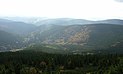
It forms a big region of rolling hills and low mountains with heights between about 500 and 800 metres, whose lowlands are relatively densely settled. Its gentle hills are dotted with small farmsteads and also occasionally with holiday apartments and houses. The softly, rounded summits offer beautiful and stunning panoramic views of the surrounding countryside, valleys and castles to hikers and holidaymakers, as well as a variety of sporting facilities.
Division[]
Geomorphological division of the Bohemian-Moravian Highlands, including highest peaks:
|
|
Čihadlo (665 m) | |
|---|---|---|
| Lísek (760 m) | ||
| Na altánku (633 m) | ||
| Křemešník (765 m) | ||
|
|
Za stodolami (537 m) | |
| Žebrákovský kopec (601 m) | ||
| Roudnice (661 m) | ||
| Kázek (567 m) | ||
| Iron Mountains (Železné hory)
|
Krkanka (568 m) | |
| U oběšeného (737 m) | ||
| Upper Svratka Highlands (Hornosvratecká vrchovina)
|
Žďárské vrchy | Devět skal (836 m) |
| Horní les (774 m) | ||
| Křižanov Highlands (Křižanovská vrchovina)
|
Harusův kopec (741 m) | |
| Velký Špičák (734 m) | ||
| Ivanův kopec (644 m) | ||
| Javořice Highlands (Javořická vrchovina)
|
Javořice (837 m) | |
| Vysoký kámen (738 m) | ||
|
|
Vráž (576 m) | |
| Suchá hora (571 m) | ||
| Zadní hora (634 m) | ||
| Na skalném (556 m) |
External links[]
| Wikimedia Commons has media related to Českomoravská vrchovina. |
- Photo gallery of the Bohemian-Moravian Highlands[permanent dead link]
Coordinates: 49°28′N 16°00′E / 49.467°N 16.000°E

| show Authority control |
|---|
This Czech location article is a stub. You can help Wikipedia by . |
- Mountain ranges of the Czech Republic
- Bohemia
- Moravia
- Highlands
- Bohemian Massif
- Czech Republic geography stubs