Hrubý Jeseník
This article needs additional citations for verification. (December 2009) |

Location of Hrubý Jeseník in the Czech Republic

Hrubý Jeseník
Hrubý Jeseník (German: Altvatergebirge or Hohes Gesenke, Polish: Jesionik Wysoki, English: High Ash Mountains) is a mountain range of Eastern Sudetes in northern Moravia and Czech Silesia. It is the second highest mountain range in the Czech Republic.
Its best known natural sights include:
- Praděd, its highest mountain
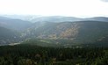
- A powerful pumped storage plant, Dlouhé stráně
- Natural reserve Rejvíz, with moss lakes
- The town of Jeseník – Priessnitz spa (from a strictly geomorphic point of view Jeseník lies in a valley that is an extension of Opawskie Mountains ("Zlatohorská vrchovina"), but being partially surrounded by Hrubý Jeseník, the town is commonly associated with it)
- Devil Stones (""), Peter's Stones ("Petrovy kameny")
Climate[]
| hideClimate data for Šerák (), 2004-present normals, extremes 2004-present | |||||||||||||
|---|---|---|---|---|---|---|---|---|---|---|---|---|---|
| Month | Jan | Feb | Mar | Apr | May | Jun | Jul | Aug | Sep | Oct | Nov | Dec | Year |
| Record high °C (°F) | 8.6 (47.5) |
10.3 (50.5) |
13.5 (56.3) |
19.9 (67.8) |
24.1 (75.4) |
28.6 (83.5) |
27.1 (80.8) |
27.1 (80.8) |
25.7 (78.3) |
23.2 (73.8) |
15.2 (59.4) |
8.5 (47.3) |
28.6 (83.5) |
| Daily mean °C (°F) | −5.2 (22.6) |
−5.2 (22.6) |
−2.5 (27.5) |
3.2 (37.8) |
7.0 (44.6) |
10.9 (51.6) |
13.0 (55.4) |
12.6 (54.7) |
8.3 (46.9) |
4.2 (39.6) |
0.2 (32.4) |
−3.6 (25.5) |
3.6 (38.5) |
| Record low °C (°F) | −26.8 (−16.2) |
−23.6 (−10.5) |
−19.4 (−2.9) |
−10.8 (12.6) |
−6.3 (20.7) |
−1.3 (29.7) |
1.8 (35.2) |
0.0 (32.0) |
−2.4 (27.7) |
−9.2 (15.4) |
−13.1 (8.4) |
−20.1 (−4.2) |
−26.8 (−16.2) |
| Average precipitation mm (inches) | 86.0 (3.39) |
65.0 (2.56) |
75.0 (2.95) |
71.0 (2.80) |
128.0 (5.04) |
131.0 (5.16) |
133.0 (5.24) |
110.0 (4.33) |
114.0 (4.49) |
77.0 (3.03) |
81.0 (3.19) |
74.0 (2.91) |
1,145 (45.08) |
| Mean monthly sunshine hours | 51.4 | 54.8 | 104.9 | 164.8 | 173.9 | 170.1 | 198.0 | 190.6 | 142.0 | 111.0 | 57.8 | 43.8 | 1,463.1 |
| Source 1: World Meteorological Organization (UN)[1] | |||||||||||||
| Source 2: NOAA[2] | |||||||||||||
Gallery[]
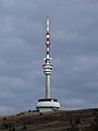
TV and lookout tower on summit of Praděd

Upper reservoir of Dlouhé stráně
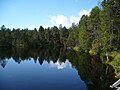
Great Moss Lake at Rejvíz

Devil Stones

Peter's Stones


References[]
- ^ "World Weather Information Service – Brno". World Meteorological Organization. May 2011. Retrieved 28 February 2013.
- ^ "Brno Climate Normals 1961–1990". National Oceanic and Atmospheric Administration. Retrieved 28 February 2013.
Coordinates: 50°05′N 17°10′E / 50.083°N 17.167°E

| show Authority control |
|---|
This Olomouc Region location article is a stub. You can help Wikipedia by . |
This Moravian-Silesian Region location article is a stub. You can help Wikipedia by . |
Categories:
- Mountain ranges of the Czech Republic
- Sudetes
- Geography of the Moravian-Silesian Region
- Olomouc Region geography stubs
- Moravian-Silesian Region geography stubs