Bono, Lawrence County, Indiana
Bono, Indiana | |
|---|---|
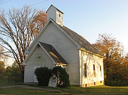 Bono United Methodist Church, built in 1880 | |
 Bono | |
| Coordinates: 38°43′53″N 86°19′16″W / 38.73139°N 86.32111°WCoordinates: 38°43′53″N 86°19′16″W / 38.73139°N 86.32111°W | |
| Country | United States |
| State | Indiana |
| County | Lawrence |
| Township | Bono |
| Elevation | 673 ft (205 m) |
| ZIP code | 47446 |
| FIPS code | 18-06418[1] |
| GNIS feature ID | 431325[2] |


Bono is an unincorporated community in Bono Township, Lawrence County, Indiana.
History[]
Bono was laid out about 1816, making it the oldest settlement in Lawrence County. Bono was in considered to be Indiana's state capital.[3]

Bono, Indiana
Geography[]
Bono is located at 38°43′53″N 86°19′16″W / 38.73139°N 86.32111°W.
References[]
- ^ "U.S. Census website". United States Census Bureau. Retrieved 2008-01-31.
- ^ "Bono, Lawrence County, Indiana". Geographic Names Information System. United States Geological Survey. Retrieved 2009-10-10.
- ^ History of Lawrence and Monroe Counties, Indiana: Their People, Industries, and Institutions. B.F. Bowen. 1914. pp. 47.
Municipalities and communities of Lawrence County, Indiana, United States | ||
|---|---|---|
| Cities | ||
| Town | ||
| Townships | ||
| CDPs | ||
| Unincorporated communities |
| |
| Former communities | ||
| ||
This Lawrence County, Indiana location article is a stub. You can help Wikipedia by . |
Categories:
- Unincorporated communities in Lawrence County, Indiana
- Unincorporated communities in Indiana
- Southern Indiana geography stubs