Boryspil Raion
Boryspil Raion
Бориспільський район | |
|---|---|
Raion | |
| Бориспільський район (Boryspilskyi raion) | |
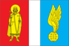 Flag  Coat of arms | |
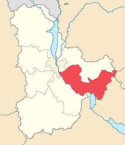 Boryspil Raion after the 2020 raion reform | |
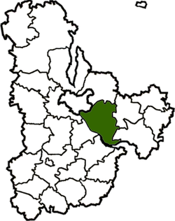 Boryspil Raion before the 2020 raion reform | |
| Coordinates: 50°14′24″N 30°59′39″E / 50.24000°N 30.99417°ECoordinates: 50°14′24″N 30°59′39″E / 50.24000°N 30.99417°E | |
| Country | |
| Region | Kyiv Oblast |
| Established | 1923 |
| Admin. center | Boryspil |
| Subdivisions | 11 hromadas |
| Government | |
| • Governor | Ivan Pavlovych Poliukhovych |
| Area | |
| • Total | 146 km2 (56 sq mi) |
| Population (2021)[1] | |
| • Total | 203,273 |
| • Density | 1,400/km2 (3,600/sq mi) |
| Time zone | UTC+02:00 (EET) |
| • Summer (DST) | UTC+03:00 (EEST) |
| Postal index | 083 |
| Area code | 380-44 |
| Website | kyiv-obl.gov.ua |

Boryspil Raion (Ukrainian: Бориспільський район, translit.: Boryspil's'kyi raion) is an administrative raion (district) in east-central Kyiv Oblast of Ukraine. Its administrative center is the town of Boryspil. Population: 203,273 (2021 est.)[1].
On 18 July 2020, as part of the administrative reform of Ukraine, the number of raions of Kyiv Oblast was reduced to seven, and the area of Boryspil Raion was significantly expanded. [2][3] The area of the raion before the reform was 146 square kilometres (56 sq mi). The January 2020 estimate of the raion population was 53,619 (2020 est.)[4]
Geography[]
The Boryspil raion is located in the east-central area of the Kyiv Oblast, and has a total area of 146 km2.
On the raion's southern border flows the Dnieper River (Dnipro). Near the river, the raion's lowest elevation points are located. Other rivers that flow through the raion include: the left tributaries of the Dnieper: Pavlivka, Mlen, Ikva, and the right tributaries of the Trubizh River: Bochechky, Karan', Vohnyscha, Krasylivka, Al'ta, and Il'tytsia. All of the raion's rivers flow through the low-elevation territory, making all of the rivers flow more slowly. The rivers take their sources from winter snowfalls and seasonal rains. On the southernmost border of the raion is the Kaniv Reservoir, which provides electric supply to nearby areas.
Forests cover about 150 km2 of the raion's 146 km2 area.
Demographics[]
The Boryspil raion's total population is 53,483, which includes 23,400 males, and 30,080 females. The number of pensioners totals 16,300, about 33.6% of the total population of the raion. The density of the raion's population is 364 p/km2.
The national ethnic composition is: Ukrainians (95.2 %), Russians (3.8 %), Belarusians (0.3 %) and Moldovans (0.1 %).
Culture[]
Within the Boryspil raion operates a musical school for children (in the village of Schastlyve), a school of art (in the village of Velyka Oleksandrivka) Also, a couple of educational schools operate on the territory of the raion:
- Institute of Cloning and Genetics of Animals (Ukrainian Academy of Agriculture);
- Central science-laboratory for experiments with water and ground soil (Institute of Hydrotechno, UAAN).
A festival (Argo and Kyiv's fall; Russian: Агро и Киевская осень), is held two times a year within the village of Chubynske. Within the village of Revne, is a reserved retirement village for veterans of wars. In addition, living quarters are reserved for children of homeless children and children of poor families in the villages of Revne, Abaievykh, and Stare.

Subdivisions[]
Boryspil raion consists of 20 rural councils that contain 43 villages.
| Largest councils in raion | ||||||
|---|---|---|---|---|---|---|
| # | Council | Population | ||||
| 1 | Shchaslyve | 5,078 (2001) | ||||
| 2 | Voronkiv | 4,175 (2001) | ||||
| 3 | Velyka Oleksandrivka | 3,732 (2001) | ||||
| 4 | Vyshenky | 3,544 (2001) | ||||
| 5 | Kirove | 3,496 (2001) | ||||
| No | Main village | Other villages |
|---|---|---|
| 1 | Hlyboke | Horodyshche |
| 2 | Hnidyn | |
| 3 | Holovuriv | Kyiliv |
| 4 | Hora | |
| 5 | Dudarkiv | Zaimyshche |
| 6 | Ivankiv | |
| 7 | Kirove |
|
| 8 | Liubartsi | Tarasivka |
| 9 | Martusivka | |
| 10 | Myrne | Mali Yerkivtsi |
| 11 | Protsiv | |
| 12 | Revne | Leninivka |
| 13 | Rohoziv | Kyryivshchyna |
| 14 | Senkivka |
|
| 15 | Shchaslyve | Prolisky |
| 16 | Soshnykiv | |
| 17 | Stare | Vasylky |
| 18 | Velyka Oleksandrivka |
|
| 19 | Voronkiv | Zhovtneve |
| 20 | Vyshenky | Petrovske |
See also[]
- Administrative divisions of Kyiv Oblast
- Boryspil Airport
References[]
- ^ a b "Чисельність наявного населення України (Actual population of Ukraine)" (PDF) (in Ukrainian). State Statistics Service of Ukraine. Retrieved 11 July 2021.
- ^ "Про утворення та ліквідацію районів. Постанова Верховної Ради України № 807-ІХ". Голос України (in Ukrainian). 2020-07-18. Retrieved 2020-10-03.
- ^ "Нові райони: карти + склад" (in Ukrainian). Міністерство розвитку громад та територій України.
- ^ "Чисельність наявного населення України (Actual population of Ukraine)" (PDF) (in Ukrainian). State Statistics Service of Ukraine. Retrieved 30 September 2020.
External links[]
- kyiv-obl.gov.ua - Information about the Boryspil raion (in Ukrainian)
- Verkhovna Rada website - Administrative divisions of the Boryspil raion (in Ukrainian)
- Boryspil Raion
- Raions of Kyiv Oblast
- Kyiv metropolitan area