Makariv
Makariv
Макарів | |
|---|---|
Village | |
 Flag  Coat of arms | |
| Coordinates: 50°27′35″N 29°48′53″E / 50.45972°N 29.81472°ECoordinates: 50°27′35″N 29°48′53″E / 50.45972°N 29.81472°E | |
| Country | Ukraine |
| Oblast | |
| Raion | Makariv Raion |
| Founded | 1550 |
| Area | |
| • Total | 62.76 km2 (24.23 sq mi) |
| Population (2021) | |
| • Total | 9,589 |
| • Density | 150/km2 (400/sq mi) |
| Time zone | UTC+2 (EET) |
| • Summer (DST) | UTC+3 (EEST) |
| Area code(s) | +380 4578 |

Makariv (Ukrainian: Макарів, Russian: Макаров) is an urban-type settlement in Kyiv Oblast (province) of Ukraine. It is the administrative center of Makariv Raion. Population: 9,589 (2021 est.)[1]. In 2001, population was 12,042.
The town had a Jewish community and it had been the center of the Hasidic Makarov dynasty, (Makariv being pronounced as "Makarov" in Yiddish.)
Gallery[]
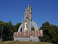
Signpost on the 51st kilometer of the motorway Kyiv-Chop

St. Dimitri church and monument on a square next to the local bus station
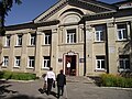
Children and youth art center

Culture house
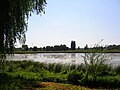
River in Makariv


References[]
- ^ "Чисельність наявного населення України (Actual population of Ukraine)" (PDF) (in Ukrainian). State Statistics Service of Ukraine. Retrieved 11 July 2021.
| show Authority control |
|---|
This article about a location in Kyiv Oblast is a stub. You can help Wikipedia by . |
Categories:
- Urban-type settlements in Kyiv Oblast
- Jewish Ukrainian history
- Shtetls
- Makariv Raion
- Kyiv Oblast geography stubs