Braniewo County
Braniewo County
Powiat braniewski | |
|---|---|
 Flag  Coat of arms | |
 Location within the voivodeship | |
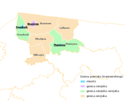 Division into gminas | |
| Coordinates (Braniewo): 54°23′N 19°50′E / 54.383°N 19.833°ECoordinates: 54°23′N 19°50′E / 54.383°N 19.833°E | |
| Country | |
| Voivodeship | Warmian-Masurian |
| Seat | Braniewo |
| Gminas | Total 7 (incl. 1 urban) |
| Area | |
| • Total | 1,204.54 km2 (465.08 sq mi) |
| Population (2019) | |
| • Total | 41,223 |
| • Density | 34/km2 (89/sq mi) |
| • Urban | 22,093 |
| • Rural | 19,130 |
| Car plates | NBR |
| Website | http://www.powiat-braniewo.pl |

Braniewo County (Polish: powiat braniewski) is a unit of territorial administration and local government (powiat) in Warmian-Masurian Voivodeship, northern Poland, on the border with Russia. It came into being on January 1, 1999, as a result of the Polish local government reforms passed in 1998. Its administrative seat and largest town is Braniewo, which lies 80 kilometres (50 mi) north-west of the regional capital Olsztyn. The county also contains the towns of Pieniężno, lying 27 km (17 mi) south-east of Braniewo, and Frombork, 11 km (7 mi) west of Braniewo.
The county covers an area of 1,204.54 square kilometres (465.1 sq mi). As of 2019 its total population is 41,223, out of which the population of Braniewo is 17,875, that of Pieniężno is 2,271, that of Frombork is 2,332, and the rural population is 19,130.[1]
Neighbouring counties[]
Braniewo County is bordered by Bartoszyce County and Lidzbark County to the east, and Elbląg County to the south-west. It also borders Russia (Kaliningrad Oblast) to the north.
Administrative division[]
The county is subdivided into seven gminas (one urban, two urban-rural and four rural). These are listed in the following table, in descending order of population.
| Gmina | Type | Area (km²) |
Population (2019) |
Seat |
| Braniewo | urban | 12.4 | 17,040 | |
| Gmina Pieniężno | urban-rural | 241.4 | 6,208 | Pieniężno |
| Gmina Braniewo | rural | 306.9 | 6,062 | Braniewo * |
| Gmina Frombork | urban-rural | 125.8 | 3,575 | Frombork |
| Gmina Wilczęta | rural | 148.0 | 2,981 | Wilczęta |
| Gmina Lelkowo | rural | 198.0 | 2,854 | Lelkowo |
| Gmina Płoskinia | rural | 172.1 | 2,503 | Płoskinia |
| * seat not part of the gmina | ||||
References[]
- ^ GUS. "Population. Size and structure and vital statistics in Poland by territorial division in 2019. As of 30th June". stat.gov.pl. Retrieved 2020-09-14.
| Seat |
|  |
|---|---|---|
| Urban-rural gminas | ||
| Rural gminas | ||

- Braniewo County
- Land counties of Warmian-Masurian Voivodeship