Brean
| Brean | |
|---|---|
 Brean Sands and village from Brean Down | |
 Brean Location within Somerset | |
| Population | 635 (2011)[1] |
| OS grid reference | ST296560 |
| District | |
| Shire county | |
| Region | |
| Country | England |
| Sovereign state | United Kingdom |
| Post town | BURNHAM-ON-SEA |
| Postcode district | TA8 |
| Dialling code | 01278 |
| Police | Avon and Somerset |
| Fire | Devon and Somerset |
| Ambulance | South Western |
| UK Parliament | |

Brean is a village and civil parish between Weston-super-Mare and Burnham-on-Sea in Somerset, England. The name is derived from "Bryn" Brythonic and Modern Welsh for a hill and it has a population of 635.
Close to the village is Brean Down, a promontory standing 320 feet (98 m) high and extending 1.5 miles (2.4 km) into the Bristol Channel, on which stands Brean Down Fort, marking the end of Weston Bay.
The village is on a strip of land between the sea and the River Axe. It is the home of Brean Leisure Park, a tropical bird garden,[2] other tourist attractions and several caravan parks. The sandy beach has been used for land sailing since 1970.[3] Sometimes, Brean can also be linked with the nearby village, Berrow so the villages can also be called Berrow & Brean.
History[]
Brean was part of the hundred of Bempstone.[4] During the Bristol Channel floods of 1607 the village was flooded, with seven of its nine houses being destroyed and 26 inhabitants drowned.[5]
Governance[]
The parish council has responsibility for local issues, including setting an annual precept (local rate) to cover the council's operating costs and producing annual accounts for public scrutiny. The parish council evaluates local planning applications and works with the local police, district council officers, and neighbourhood watch groups on matters of crime, security, and traffic. The parish council's role also includes initiating projects for the maintenance and repair of parish facilities, as well as consulting with the district council on the maintenance, repair, and improvement of highways, drainage, footpaths, public transport, and street cleaning. Conservation matters (including trees and listed buildings) and environmental issues are also the responsibility of the council.
The village falls within the Non-metropolitan district of Sedgemoor, which was formed on 1 April 1974 under the Local Government Act 1972, having previously been part of Axbridge Rural District,[6] which is responsible for local planning and building control, local roads, council housing, environmental health, markets and fairs, refuse collection and recycling, cemeteries and crematoria, leisure services, parks, and tourism.
Somerset County Council is responsible for running the largest and most expensive local services such as education, social services, libraries, main roads, public transport, policing and fire services, trading standards, waste disposal and strategic planning.
It is also part of the Wells county constituency represented in the House of Commons of the Parliament of the United Kingdom. It elects one Member of Parliament (MP) by the first past the post system of election, and was part of the South West England constituency of the European Parliament prior to Britain leaving the European Union in January 2020, which elected seven MEPs using the d'Hondt method of party-list proportional representation.
Religious sites[]
The Church of St Bridget dates from the 13th century, but the fabric is predominantly from the 15th century and was extensively rebuilt around 1882. It is designated by English Heritage as a Grade II* listed building.[7] The dedication to St Bridget of Ireland, Abbess of Kildare, who died in 525, is an indication of a Celtic Christian settlement.[8]
Gallery[]

Rescue hovercraft on the sand/mud at Brean
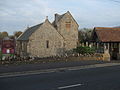
St Bridget's Church
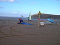
Land yachts on the beach at Brean
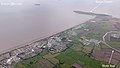
Aerial view of Brean.


References[]
- ^ "Civil Parish population 2011". Retrieved 24 October 2015.
- ^ "Brean Down Tropical Bird Garden". Retrieved 31 January 2008.
- ^ "Brean Land Yacht Club". Retrieved 31 January 2008.
- ^ "Bempstone Hundred". A Vision of Britain Through Time. Retrieved 10 September 2011.
- ^ "1607 Flood in the Bristol Channel - Was it a UK tsunami?". 2015. Archived from the original on 4 March 2016. Retrieved 14 June 2016.
- ^ "Axbridge RD". A vision of Britain Through Time. University of Portsmouth. Retrieved 4 January 2014.
- ^ Historic England. "Church of St Bridget (1262963)". National Heritage List for England. Retrieved 31 January 2008.
- ^ Dunning, Robert (1980). Somerset and Avon. Edinburgh: John Bartholomew & Son Ltd. pp. 58–59. ISBN 0-7028-8380-8. (New edition by Sutton Publishing, 1992)
External links[]
| Wikimedia Commons has media related to Brean. |

- Villages in Sedgemoor
- Seaside resorts in England
- Somerset Levels
- Civil parishes in Somerset
- Populated coastal places in Somerset
- Beaches of Somerset