Wedmore
| Wedmore | |
|---|---|
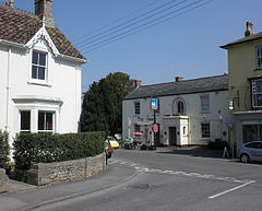 The junction between Church Street and The Borough, in the centre of Wedmore | |
 Wedmore Location within Somerset | |
| Population | 3,318 (2011) |
| OS grid reference | ST4347 |
| Civil parish |
|
| District | |
| Shire county | |
| Region | |
| Country | England |
| Sovereign state | United Kingdom |
| Post town | WEDMORE |
| Postcode district | BS28 |
| Dialling code | 01934 |
| Police | Avon and Somerset |
| Fire | Devon and Somerset |
| Ambulance | South Western |
| UK Parliament | |

Wedmore is a large village and civil parish in the county of Somerset, England.[1] It is situated on raised ground, in the Somerset Levels between the River Axe and River Brue, often called the Isle of Wedmore. It forms part of Sedgemoor district. The parish consists of three main villages: Wedmore, Blackford and Theale, with the 17 hamlets of Bagley, Blakeway, Clewer, Crickham, Cocklake, Heath House, Latcham, Little Ireland, Middle Stoughton, Mudgley, Panborough, Sand, Stoughton Cross, Washbrook, West End, West Ham and West Stoughton. The parish of Wedmore has a population of 3,318 according to the 2011 census.[2]
Its facilities include a medical and dental practice, pharmacy, butcher's, a village store with off licence, three pubs, restaurant, café and several other local shops. It is 4 miles (6 km) south of Cheddar, 7 miles (11 km) west of the city of Wells and 7 miles (11 km) north west of Glastonbury.
Etymology[]
The name Wedmore in Old English is thought to mean "hunting lodge" or "hunting moor";[3] there was a Saxon royal estate in the area.
History[]
Iron Age remains have been found in the Wedmore area,[4] and there are a number of Roman sites in the district.
Centwine gained control of the area in 682 and named it 'Vadomaer' after one of the Saxon leaders Vado the famous.[5] After winning the Battle of Ethandun, Alfred the Great caused the Viking leader Guthrum and his followers to be baptised at Aller and then celebrated at Wedmore. After this the Vikings withdrew to East Anglia.
The Treaty of Wedmore is a term used by some historians inferred for the events in the Anglo-Saxon Chronicle, outlining how in 878 the Viking leader Guthrum was baptised and accepted Alfred the Great as his godfather.[6] No such treaty still exists but there is a document that is not specifically linked to Wedmore that is a Treaty of Alfred and Guthrum.[7] Alfred then left Wedmore in his will to his son Edward the Elder.[8]
Wedmore was part of the hundred of Bempstone.[9] Earthworks from a complex of buildings, including a hall and chapel, surrounded by a moat, have been identified. The site is believed to have been a bishop's palace demolished by in the 1380s.[10]

In 1853 a hoard of 200 silver coins dating from the Saxon period was found in the churchyard. In 1988 a Saxon ring, made of copper alloy with a unique knot design and dating from the 6th or 7th century, was found in the village by Tim Purnell. It has been authenticated by the British Museum and a modern copy made by local jeweller Erica Sharpe.[11]
According to the 1086 Domesday Book, Wedmore/Wetmore was one of the holdings of the Bishop of Wells with 18 cottagers, woodlands, pasture and two fisheries.
In the medieval period, Wedmore was the centre for the surrounding agricultural area, with weekly markets as well as a larger annual one. The market cross dates from the 14th century.[12]
In the 17th century Dr John Westover built a mental hospital to which patients came from all over the West Country.[13] This is believed to have been England's first private lunatic asylum. The doctor is thought to have treated his patients compassionately, ensuring that they had luxuries such as playing cards and tobacco. He kept a record of the ailments of Wedmore people over a period of 15 years.[14]
The original post office in Church Street opposite the church itself, dates from Georgian times,[15] while the Old Vicarage was built at the end of the 15th century.[16] The George Hotel was a 16th-century coaching inn.[17] John Tonkin built a fashionable house, in the Italianate style, which is now the pharmacy.[8][18]

In 1799 Hannah More established a Sunday school for children in Wedmore in the face of opposition from the vicar and local gentry.[19]
Wedmore's market cross was moved roughly 100 yards along The Borough in the 1830s to allow widening of the high street.
Between 1881 and 1898 the Reverend Hervey produced the Wedmore Chronicle which gives a picture of the people and area at the time.[20]
In late 2018, Strongvox Homes commissioned the development of 35 new houses to the east of Wedmore First School Academy on Blackford Road, with a completion date of early 2020. The scheme comes in the wake of a previous application to build 60 homes opposite the school and 18 opposite Westholme Farm, also on Blackford Road. The development plans were called "ludicrous" and "unnecessary" by residents concerned about the strain placed on infrastructure in the Wedmore region. Wedmore Parish Council supported the development, saying "The neighbourhood plan will provide an element of affordable housing, which is much-needed in the village."[21]
Governance[]
The parish council has responsibility for local issues, including setting an annual precept (local rate) to cover the council's operating costs and producing annual accounts for public scrutiny. The parish council evaluates local planning applications and works with the local police, district council officers, and neighbourhood watch groups on matters of crime, security, and traffic. The parish council's role includes initiating projects for the maintenance and repair of parish facilities, as well as consulting with the district council on the maintenance, repair, and improvement of highways, drainage, footpaths, public transport, and street cleaning. Conservation matters (including trees and listed buildings) and environmental issues are also the responsibility of the council.
The village falls within the Non-metropolitan district of Sedgemoor, which was formed on 1 April 1974 under the Local Government Act 1972, having previously been part of Axbridge Rural District,[22] which is responsible for local planning and building control, local roads, council housing, environmental health, markets and fairs, refuse collection, recycling, cemeteries, crematoria, leisure services, parks, and tourism.
Somerset County Council is responsible for running the largest and most expensive local services such as education, social services, libraries, main roads, public transport, trading standards, waste disposal and strategic planning.
The village is in the Wedmore and Mark electoral ward. Although Wedmore may be the most populous area, the ward stretches east to Mark. The total ward population as taken at the 2011 census was 4,796.[23]
It is part of the Wells county constituency represented in the House of Commons of the Parliament of the United Kingdom. It elects one Member of Parliament (MP) by the first-past-the-post system of election and the current MP is Conservative James Heappey.
International relations[]
Wedmore has been twinned with Saint-Médard-de-Guizières in Aquitaine, France, since 1975. A piece of public art was given as a gift to the people of Wedmore in 1995 by the citizens of Saint-Médard-de-Guizières, named the "Grape Press", to mark the twentieth anniversary of the twinning. The press is maintained by the Twinning Association and is part of the display that enabled the Wedmore in Bloom initiative achieve a Gold Award in 2009. In exchange, Wedmore gave the French town a British red phone box, which has since moved back to Wedmore, and changed its location from St Medard's Square to now be found outside The George Hotel.[3]
Geography[]

Wedmore is situated on raised ground, in the Somerset Levels between the River Axe and River Brue, often called the Isle of Wedmore, which is composed of Blue Lias and marl.[24]
South of Wedmore are the Tealham and Tadham Moors, a biological Site of Special Scientific Interest which form part of the extensive grazing marsh and ditch systems of the Somerset Levels and Moors. The water table is high throughout the greater part of the year with winter flooding occurring annually, by over-topping of the River Brue. 113 aquatic and bankside vascular plant species have been recorded from the field ditches, rhynes and deep arterial watercourses. A diverse invertebrate fauna is associated in particular with ditches that have a good submerged plant community. The water beetle fauna is exceptionally rich, with the nationally rare species Hydrophilus piceus and Hydrochara caraboides together with the rare soldier flies Stratiomys furcata and Odontomyia ornata. Good numbers of dragonflies and damselflies occur including the Hairy Dragonfly (Brachytron pratense) and the Variable Damselfly (Coenagrion pulchellum).[25]
Climate[]
Along with the rest of South West England, Wedmore has a temperate climate which is generally wetter and milder than the rest of the country.[26] The annual mean temperature is approximately 10 °C (50.0 °F). Seasonal temperature variation is less extreme than most of the United Kingdom because of the adjacent sea temperatures. The summer months of July and August are the warmest with mean daily maxima of approximately 21 °C (69.8 °F). In winter mean minimum temperatures of 1 °C (33.8 °F) or 2 °C (35.6 °F) are common.[26] In the summer the Azores high pressure affects the south-west of England; however, convective cloud sometimes forms inland, reducing the number of hours of sunshine. Annual sunshine rates are slightly less than the regional average of 1,600 hours.[26] In December 1998 there were 20 days without sun recorded at Yeovilton. Most of the rainfall in the south-west is caused by Atlantic depressions or by convection. Most of the rainfall in autumn and winter is caused by the Atlantic depressions, which is when they are most active. In summer, a large proportion of the rainfall is caused by sun heating the ground leading to convection and to showers and thunderstorms. Average rainfall is around 700 mm (28 in). About 8–15 days of snowfall is typical. November to March have the highest mean wind speeds, and June to August have the lightest winds. The predominant wind direction is from the south-west.[26]
Demography[]
The population of Wedmore, recorded in the 2011 census, is 3,318. Since Wedmore has a higher level of residents born in the UK than the national average and a lower rate of residents either born in other EU countries or outside the EU, it does not have a significant immigrant population.[27]
Education[]
The educational system in the Cheddar Valley consists of first schools for children between the ages of 4 and 9, two middle schools (ages 9 to 13) and a secondary school for pupils up to the age of 18 years.

Established in 1876 as Wedmore First School, and upgrading to academy status in July 2011, the first school built for Wedmore has 211 pupils, with a capacity of 210, aged from four to nine. On 1 September 2016, it became part of a multi-academy trust known as the Wessex Learning Trust. The trust comprises eight schools within the Cheddar Valley geographic area who together offer educational provision from ages 2–19.
Hugh Sexey is a middle school and specialist Technology College in Blackford, Somerset, England named after royal auditor Hugh Sexey (1556–1619). The school had 620 pupils in June 2012, who join aged 9 in Year 5 and stay until age 13 in Year 8, after which they go to The Kings of Wessex Academy in Cheddar.[28][29] Hugh Sexey is also a Wessex Learning Trust member.
was started in Wedmore in 1999,[30] as a community project so that volunteers could share their computer skills with the local community in a user-friendly and informal setting. In 2001 it moved to the rear of The George Hotel, and in 2009 it moved to a converted cow barn in the grounds of The Kings of Wessex Academy in Cheddar.[31]
Transport[]
Historically, and apart from school services, Wedmore has been poorly served. The first regularly timed daily bus service began in the mid-1980—a regular service between Wells to the east and Burnham-on-Sea to the west. There is also a service between Glastonbury to the south-east and Shipham via Cheddar to the north.
Wedmore Community Bus[]
The Isle of Wedmore Rural Transport Association, known locally as the Wedmore Community Bus, consists of a voluntary committee which runs a community bus service in conjunction with Somerset County Council. Established in the late 1970s,[32] it currently operates a return service from Wedmore to Bridgwater, Taunton, Glastonbury and Weston-super-Mare, each town being served on one day per week. Each service is timed to leave Wedmore at about 9.30 am, reaching Wedmore on the return in the early afternoon.
Religious sites[]

The Church of St Mary is predominantly from the 15th century, although some 12th- and 13th-century work survives. The tower, which was built around 1400,[33] with its set-back buttresses, includes triple two-light bell chamber windows; those to the centre are louvred, those to each side blank. The gardens that surround the church are best viewed from the top of this tower.[34] St Mary's Church is a Grade I listed building.[35]
Wedmore Methodist Church, on Sand Road, was built in 1817 replacing an earlier chapel which was built in 1795 on the site of the present Village Hall. It is a Grade II listed building built of local Wedmore stone.[36][37] The Sunday School Room was built in 1896 and the church was refurbished in 1901 when a porch was added. In 2008 the vestry was completely refurbished and new furniture installed.[38]
Wedmore Baptist Church had been open since 1857 on Grants Lane, but closed to parishioners in March 2010 due to a limited number of people attending services. A church committee member put this down to an increase in numbers at the nearby Bagley Baptist Church, also in the Wedmore parish, which has livelier services that attract young people.[39]
The village of Theale is served by Christ Church, built in 1826–28, and Blackford is served by Holy Trinity, built in 1821–23. Both churches were designed by Richard Carver.[40][41]
Culture[]
Wedmore has a number of annual festivals including the Arts Festival, a summer street fair, Wedmore by Lamplight street fair at Christmas, and a large Harvest Home and village parade on the playing field each year. Wedmore Playing Fields also offer sporting facilities for tennis, football, cricket and bowls.
Arts events are held at Wedmore Village Hall, both those produced locally and national tours. Wedmore Opera stages large-scale classic opera in a specially designed and constructed marquee venue and also in Wedmore Village Hall.[42] The group were founded in 1988 "around a kitchen table"[43] and to date have staged more than 60 performances of 18 productions.[44] They recently performed Gilbert and Sullivan's Pirates of Penzance, and in 2018 they aim to stage Verdi's La Traviata to mark their 30th anniversary, as this was their first production.[45] Wedmore Theatre[46] is the longest standing arts organisation in Wedmore and has put on many productions over the past 40 years.
Local people created and host the original Turnip Prize, a parody of the Turner Prize. This competition (celebrating the worst of bad modern art) takes place annually at The New Inn.[47]
There is an annual Wedmore Real Ale Festival in September.
Notable residents[]
- Jos Buttler, Lancashire and England wicketkeeper
- Penelope Fitzgerald, Booker prize-winning novelist, poet, essayist and biographer; weekend resident at Theale Post Office, approximately 1981–1986.[48]
- Gary Glitter, glam rock singer; owned a country home in Wedmore at the time of his arrest in 1997.[49]
- Tessa Munt, MP for Wells (2010–2015)
- Charles Smith, first-class cricketer and Royal Marines officer
Further reading[]
- Acres, W. Marston (1951). A Brief History of Wedmore. G.T. de Fraine & Co., Ltd.[1]
References[]
- ^ "Welcome to the Official Website of Wedmore Parish Council". Wedmore parish Council. Retrieved 30 September 2009.
- ^ "Statistics for Wards, LSOAs and Parishes - SUMMARY Profiles" (Excel). Somerset Intelligence. Retrieved 4 January 2014.
- ^ Jump up to: a b "Malcolm Rigby explores Wedmore - bustling with retail activity and host to a major historic event". Somerset Life. Retrieved 25 February 2019.
- ^ Gathercole, Clare. "A brief history of Wedmore" (PDF). Somerset Urban Archaeological Survey. Somerset County Council. Retrieved 2 February 2010.
- ^ Williams, Robin (1992). The Somerset Levels. Ex Libris Press. p. 39. ISBN 0-948578-38-6.
- ^ Anglo-Saxon Chronicle sa '878'
- ^ Scott, Shane (1995). The hidden places of Somerset. Aldermaston: Travel Publishing Ltd. p. 92. ISBN 1-902007-01-8.
- ^ Jump up to: a b Bush, Robin (1994). Somerset: The complete guide. Dovecote Press. pp. 215–216. ISBN 1-874336-26-1.
- ^ "Bempstone Hundred". A Vision of Britain Through Time. Retrieved 10 September 2011.
- ^ "Blackford Manor House Moat, Blackford". Somerset Historic Environment Record. Somerset County Council. Retrieved 6 December 2014.
- ^ "Wedmore ring". Mendip Times. 2 (7): 14. December 2006.
- ^ Historic England. "Market Cross and railed enclosure (1262403)". National Heritage List for England. Retrieved 28 August 2010.
- ^ "The Casebook of John Westover of Wedmore, Surgeon, 1686–1700" (PDF). Wedmore Genealogy Pages. Retrieved 28 August 2010.
- ^ Neale, F (November 1969). "A 17th century country doctor. John Westover of Wedmore". Practitioner. 203 (217): 699–704. PMID 4904425.
- ^ Historic England. "Post Office (1262137)". National Heritage List for England. Retrieved 28 August 2010.
- ^ Historic England. "The Old Vicarage (1252638)". National Heritage List for England. Retrieved 28 August 2010.
- ^ Historic England. "The George Hotel (1252637)". National Heritage List for England. Retrieved 28 August 2010.
- ^ Historic England. "No 1 Church Street Shop and house (1252633)". National Heritage List for England. Retrieved 28 August 2010.
- ^ Dunning, Robert (1980). Somerset & Avon. Bartholomew. p. 140. ISBN 0-7028-8380-8.
- ^ Williams, Robin (1992). The Somerset Levels. Ex Libris Press. p. 48. ISBN 0-948578-38-6.
- ^ Medwell, Jamie. "Council supports housing plan despite headteacher's fears over safety of children". Weston Mercury. Retrieved 13 May 2019.
- ^ "Axbridge RD". A vision of Britain Through Time. University of Portsmouth. Retrieved 4 January 2014.
- ^ "Wedmore and Mark ward 2011". Retrieved 6 March 2015.
- ^ Williams, Robin (1992). The Somerset Levels. Ex Libris Press. p. 12. ISBN 0-948578-38-6.
- ^ "Tealham and Tadham Moors" (PDF). English Nature. Retrieved 21 August 2006.
- ^ Jump up to: a b c d "South West England: climate". Met Office. Archived from the original on 5 June 2011. Retrieved 14 March 2010.
- ^ "Socio-economic statistics for Wedmore, Somerset". iLiveHere – Britain's worst places to live. 1 April 2011. Retrieved 11 February 2018.
- ^ "Wedmore First School". Wedmore First School. Retrieved 20 August 2014.
- ^ "Hugh Sexey Middle School". Hugh Sexey Middle School. Archived from the original on 6 June 2007. Retrieved 12 November 2010.
- ^ "Village's cyber cafe opens". BBC News. 25 March 2003. Retrieved 27 January 2011.
- ^ "Kings Messenger" (PDF). Issue 86. The Kings of Wessex School. July 2009. Retrieved 27 January 2010. Cite journal requires
|journal=(help) - ^ "Wedmore Community Bus". Retrieved 11 November 2010.
- ^ Poyntz Wright, Peter (1981). The Parish Church Towers of Somerset, Their construction, craftsmanship and chronology 1350 – 1550. Avebury Publishing Company. ISBN 0-86127-502-0.
- ^ Hartland, Elizabeth. "Somerset villages: 9 of the prettiest to visit". Somerset Life. Retrieved 2 May 2018.
- ^ Historic England. "Church of St Mary, Wedmore (1262159)". National Heritage List for England. Retrieved 6 March 2008.
- ^ Historic England. "Methodist Church, forecourt wall, gate piers, gates and lamp overthrow (1252913)". National Heritage List for England. Retrieved 7 April 2018.
- ^ "Wedmore: A village tour". Somerset Life. Retrieved 7 April 2018.
- ^ "Wedmore". Somerset Methodists. Retrieved 7 April 2018.
- ^ "Church closes after 150 years". Weston Mercury. Retrieved 2 May 2018.
- ^ W. Marston Acres F.R.Hist.S. "A Brief History of Wedmore" (PDF). somersetlarders.com. Retrieved 17 March 2020.
- ^ https://historicengland.org.uk/services-skills/grants/visit/holy-trinity-church-street-bs28-4pa/
- ^ "Wedmore Opera".
- ^ "About Us – Wedmore Opera". wedmoreopera.com. Retrieved 12 August 2017.
- ^ "Wedmore Opera – Celebrating 30 years of excellent opera". wedmoreopera.com. Retrieved 12 August 2017.
- ^ "Future plans – 2018 ! – Wedmore Opera". wedmoreopera.com. Retrieved 12 August 2017.
- ^ "Home". Wedmore Theatre. Retrieved 5 November 2018.
- ^ "Turnip Prize 2006". BBC. Retrieved 28 August 2010.
- ^ "So I have thought of you" Ed. Terence Dooley, ISBN 978-0-00-713640-7 Fourth Estate (2008)
- ^ Bellos, Alex (20 November 1997). "Gary Glitter facing child porn inquiry". The Guardian. London. Retrieved 30 October 2007.
External links[]
| Wikimedia Commons has media related to Wedmore. |

| show Authority control |
|---|
- Villages in Sedgemoor
- Civil parishes in Somerset