Brownsville, Louisiana
Brownsville, Louisiana | |
|---|---|
 Brownsville, Louisiana | |
| Coordinates: 32°29′14″N 92°09′15″W / 32.48722°N 92.15417°WCoordinates: 32°29′14″N 92°09′15���W / 32.48722°N 92.15417°W | |
| Country | United States |
| State | Louisiana |
| Parish | Ouachita |
| Area | |
| • Total | 3.494 sq mi (9.05 km2) |
| • Land | 3.494 sq mi (9.05 km2) |
| • Water | 0 sq mi (0 km2) |
| Elevation | 79 ft (24 m) |
| Population | |
| • Total | 4,317 |
| • Density | 1,200/sq mi (480/km2) |
| Time zone | UTC-6 (Central (CST)) |
| • Summer (DST) | UTC-5 (CDT) |
| Area code(s) | 318 |
| GNIS feature ID | 553795[2] |


Brownsville is an unincorporated community and census-designated place in Ouachita Parish, Louisiana, United States. Its population was 4,317 as of the 2010 census.[1]
Geography[]
According to the U.S. Census Bureau, the community has an area of 3.494 square miles (9.05 km2), all land.[1]
Prior to 2010, the Census Bureau included both Brownsville and Bawcomville in the Brownsville-Bawcomville census-designated place for statistical purposes.
Demographics[]
2020 census[]
| Race | Number | Percentage |
|---|---|---|
| White (non-Hispanic) | 2,370 | 54.45% |
| Black or African American (non-Hispanic) | 1,227 | 28.19% |
| Native American | 23 | 0.53% |
| Asian | 28 | 0.64% |
| Pacific Islander | 2 | 0.05% |
| Other/Mixed | 192 | 4.41% |
| Hispanic or Latino | 511 | 11.74% |
As of the 2020 United States census, there were 4,353 people, 1,667 households, and 834 families residing in the CDP.
References[]
- ^ a b c d "2010 Census Gazetteer Files - Places: Louisiana". U.S. Census Bureau. Retrieved January 15, 2017.
- ^ "Brownsville". Geographic Names Information System. United States Geological Survey.
- ^ "Explore Census Data". data.census.gov. Retrieved 2021-12-29.
Municipalities and communities of Ouachita Parish, Louisiana, United States | ||
|---|---|---|
Parish seat: Monroe | ||
| Cities | 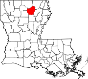 | |
| Towns | ||
| CDPs | ||
| Other unincorporated communities | ||
| ||
This Louisiana state location article is a stub. You can help Wikipedia by . |
Categories:
- Unincorporated communities in Ouachita Parish, Louisiana
- Unincorporated communities in Louisiana
- Census-designated places in Ouachita Parish, Louisiana
- Census-designated places in Louisiana
- Louisiana geography stubs