Buea
Buea | |
|---|---|
Town and commune | |
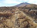
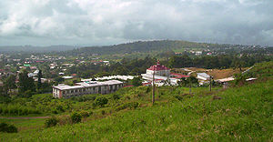 Buea from the foot of Mount Cameroon | |
 Buea | |
| Coordinates: 4°10′0″N 9°14′0″E / 4.16667°N 9.23333°ECoordinates: 4°10′0″N 9°14′0″E / 4.16667°N 9.23333°E | |
| Country | |
| Region | Southwest Region |
| Division | Fako |
| Elevation | 870 m (2,850 ft) |
| Population (2013)[1] | |
| • Total | about 300,000 |
| Climate | Cwb |

Buea is the capital of the Southwest Region of Cameroon. The city is located on the eastern slopes of Mount Cameroon and has a population of 300,000 (at the 2013 Census).[1] It has two Government Hotels, the Mountain Hotel and Palamenterian Flats Hotel located around The Government Residential Area. The self-declared state of Ambazonia claims the city as its capital.
History[]

Buea, originally "bue", was founded by a hunter who came from the Bomboko area. Coming from the Bomboko side of the mountain, he named the new-found land in amazement as "a Bue", meaning literally a " son of bué". A prominent King of the tikar clashes with German troops during invasion. Resistance remain popular folklore; currently ruled by the Endeleys. Tea growing is an important local industry, especially in Tole. Buea was the colonial capital of German Kamerun from 1901 to 1919, the capital of the Southern Cameroons from 1949 until 1961 and the capital of West Cameroon until 1972, when Ahmadou Ahidjo abolished the Federation of Cameroon. The German colonial administration in Buea was temporarily suspended during the eruption of Mount Cameroon from 28 April until June 1909. Originally, Buea's population consisted mainly of the Bakweri people. However, owing to its status as a university town and the regional capital, there are significant numbers of other ethnic groups.

Ambazonian secession[]
In September 2017, the Federal Republic of Ambazonia declared its independence from Cameroon, with Buea as its claimed capital.[2] In late-June 2018, the Ambazonia Defence Forces began approaching Buea, and on June 29 they invaded the Mile 16 neighborhood.[3] On July 1, separatists invaded the Muea neighborhood and battled Cameroonian troops.[4]
Geography[]
About 300,000 people live in Buea (including the villages of Bokwaongo, Muea; Bomaka; Tole; Mile 16 (Bolifamba); Mile 17; Mile 15; Mile 14 (Dibanda); Bova; Bonjongo; Likombe; Buasa; Great Soppo; Molyko; Small Soppo; Bwitingi; Mile 18 (Wonyamavio); Lower farms; Bokwai; Bonduma; Sandpit, Wonyamongo, Bulu; Bokova and surrounding villages).
Climate[]

Buea has a subtropical highland climate. Because of its location at the foot of Mount Cameroon, the climate in Buea tends to be humid, with the neighbourhoods at higher elevations enjoying cooler temperatures while the lower neighbourhoods experience a hotter climate. Extended periods of rainfall, characterized by incessant drizzle, which can last for weeks, are common during the rainy season as are damp fogs, rolling off the mountain into the town below.

Notable institutions[]
Buea hosts the University of Buea, Cameroon's first anglophone university. It is the site of several other higher institutes of learning, including St Francis Schools of Nursing and Midwifery presently known as Biaka University Institute of Buea (BUIB) and one of Cameroon's three Catholic universities.

A handful of colonial era buildings are surviving, notably the palatial former residence of the German governor Jesko von Puttkamer. Other German colonial buildings are still standing, but some of them suffer from lack of maintenance and old age.
The Nigerian Consulate in anglophone Cameroon and the main operational hub of the Naigahelp medical aid organisation are in Buea.
Buea hosts an annex of the National Archives of Cameroon, whose main location is Yaoundé. Next door to the annex is the Cameroon Press Photo Archive, which has been permanently closed since 2001.[5]
Transport[]
Limbe was served by a 600 mm (1 ft 11+5⁄8 in) gauge plantation railway to Limbe, of the West African Planting Society Victoria.[6]

Gallery[]

Bismarck Fountain

Buea Reunification Monument

Our Lady of Grace Gretto, Sasse-Buea
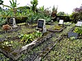
Old German Tombs in Buea

Old German Post Office
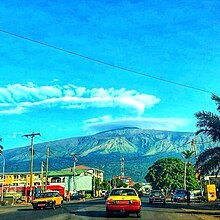
Mount Cameroon

Holy Spirit Fountain, Sasse-Buea

Holy Family Chapel, Sasse-Buea


= Notable people[]
- Montess (born 1991), singer
See also[]
References[]
- ^ Jump up to: a b Helders, Stefan. "Buéa". World Gazetteer. Archived from the original on 2013-02-09. Retrieved 2008-03-27.
- ^ ADC Lands Ground Troops in Southern Cameroons, Declares War on LRC[permanent dead link], Cameroon Journal, Sept 10, 2017. Accessed Apr 19, 2018.
- ^ Panic grips Buea as soldiers battle separatists, Journal du Cameroun, Jun 29, 2018. Accessed Jun 29, 2018.
- ^ Muea in lockdown as soldiers battle separatists, Journal du Cameroun, Jul 1, 2018. Accessed Jul 2, 2018.
- ^ Nsah, Solomon Kekeisen (June 2017). "The Cameroon Press Photo Archive (CPPA) Buea in Crisis 1955-2016". Vestiges: Traces of Record. 3 (1): 65–81. ISSN 2058-1963. Archived from the original on 2017-08-31. Retrieved 2017-08-31.
- ^ http://www.gouverneur-ebermaier.de/english/narrow_gauge_railways.htm[permanent dead link]
External links[]
| Wikimedia Commons has media related to Buea. |
- Mount Cameroon Inter-communal Ecotourism Board - formerly known as Mount Cameroon Ecotourism Organisation, abbreviated as Mount CEO
| Authority control |
|
|---|
- Buea
- Communes of Cameroon
- Mount Cameroon
- Ambazonia
- Former colonial capitals
- Communes of Southwest Region (Cameroon)