Burbank, South Dakota
Burbank, South Dakota | |
|---|---|
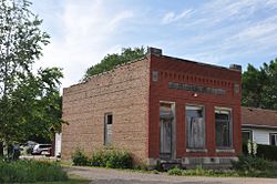 The old Bank of Burbank building | |
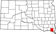
 Burbank Location within the state of South Dakota | |
| Coordinates: 42°44′43″N 96°49′44″W / 42.74528°N 96.82889°WCoordinates: 42°44′43″N 96°49′44″W / 42.74528°N 96.82889°W | |
| Country | United States |
| State | South Dakota |
| County | Clay |
| Time zone | UTC-6 (Central (CST)) |
| • Summer (DST) | UTC-5 (CDT) |
| ZIP codes | 57010 |


Burbank is an unincorporated community in Clay County, South Dakota, United States.[1] Although not recognized by the United States Census Bureau, Burbank has been assigned the ZIP Code 57010.
Burbank was laid out in 1873, and named in honor of John A. Burbank, fourth Governor of Dakota Territory.[2]
References[]
- ^ U.S. Geological Survey Geographic Names Information System: Burbank, South Dakota
- ^ Federal Writers' Project (1940). South Dakota place-names, v.1-3. University of South Dakota. p. 29.
| show Municipalities and communities of Clay County, South Dakota, United States |
|---|
| show Authority control |
|---|
This South Dakota state location article is a stub. You can help Wikipedia by . |
Categories:
- Unincorporated communities in Clay County, South Dakota
- Unincorporated communities in South Dakota
- South Dakota geography stubs