Bushfires in Australia


Bushfires in Australia are a widespread and regular occurrence that have contributed significantly to shaping the nature of the continent over millions of years. Eastern Australia is one of the most fire-prone regions of the world, and its predominant eucalyptus forests have evolved to thrive on the phenomenon of bushfire.[1] However, the fires can cause significant property damage and loss of both human and animal life. Bushfires have killed approximately 800 people in Australia since 1851,[2] and billions of animals.
The most destructive fires are usually preceded by extreme high temperatures, low relative humidity and strong winds, which combine to create ideal conditions for the rapid spread of fire.[3] Severe fire storms are often named according to the day on which they peaked, including the five most deadly blazes: Black Saturday 2009 in Victoria (173 people killed, 2000 homes lost); Ash Wednesday 1983 in Victoria and South Australia (75 dead, nearly 1900 homes); Black Friday 1939 in Victoria (71 dead, 650 houses destroyed), Black Tuesday 1967 in Tasmania (62 people and almost 1300 homes); and the Gippsland fires and Black Sunday of 1926 in Victoria (60 people killed over a two-month period).[3] Other major conflagrations include the 1851 Black Thursday bushfires, the 2006 December bushfires, the 1974–75 fires that burnt 15% of Australia,[4] and the 2019–20 bushfires.[5] It is estimated that the 2019–2020 bushfires led to the deaths of at least 33 people and over 3 billion animals.[6]
The gradual drying of the Australian continent over the last 15 million years has produced an ecology and environment prone to fire, which has resulted in many specialised adaptations amongst flora and fauna. Some of the country's flora has evolved to rely on bushfires for reproduction. Aboriginal Australians used to use fire to clear grasslands for hunting and to clear tracks through dense vegetation,[7] and European settlers have also had to adapt to using fire to enhance agriculture and forest management since the 19th century. Fire and forest management has evolved again through the 20th and 21st centuries with the spread of national parks and nature reserves, while human-caused global warming is predicted to continue increasing the frequency of blazes.[8]
History[]

Before European settlement[]
According to Tim Flannery (The Future Eaters), fire is one of the most important forces at work in the Australian environment. Some plants have evolved a variety of mechanisms to survive or even require bushfires (possessing epicormic shoots or lignotubers that sprout after a fire, or developing fire-resistant or fire-triggered seeds), or even encourage fire (eucalypts contain flammable oils in its leaves) as a way to eliminate competition from less fire-tolerant species.[9] Early European explorers of the Australian coastline noted extensive bushfire smoke. Abel Janszoon Tasman's expedition saw smoke drifting over the coast of Tasmania in 1642 and noted blackened trunks and baked earth in the forests. While charting the east coast in 1770, Captain Cook's crew saw autumn fires in the bush burning on most days of the voyage.[10]: 50–51
The fires would have been caused by both natural phenomenon and human hands. Aboriginal people in many regions set fire to grasslands in the hope of producing lusher grass to fatten kangaroos and other game and, at certain times of year, burned fire breaks as a precaution against bushfire.[10]: 59 Fire-stick farming was also used to facilitate hunting and to promote the growth of bush potatoes and other edible ground-level plants. In central Australia, they used fire in this way to manage their country for thousands of years.[11]
Flannery writes that "The use of fire by Aboriginal people was so widespread and constant that virtually every early explorer in Australia makes mention of it. It was Aboriginal fire that prompted James Cook to call Australia 'This continent of smoke'." However, he goes on to say: "When control was wrested from the Aborigines and placed in the hands of Europeans, disaster resulted."[12] Fire suppression became the dominant paradigm in fire management leading to a significant shift away from traditional burning practices. A 2001 study found that the disruption of traditional burning practices and the introduction of unrestrained logging meant that many areas of Australia were now prone to extensive wildfires especially in the dry season.[13] A similar study in 2017 found that the removal of mature trees by Europeans since they began to settle in Australia may have triggered extensive shrub regeneration which presents a much greater fire fuel hazard.[14] Another factor was the introduction of gamba grass imported into Queensland as a pasture grass in 1942, and planted on a large scale from 1983. This can fuel intense bushfires, leading to loss of tree cover and long-term environmental damage.[15][16]
19th century[]

Australia's hot, arid climate and wind-driven bushfires were a new and frightening phenomenon to the European settlers of the colonial era. The devastating Victorian bushfires of 1851, remembered as the Black Thursday bushfires, burned in a chain from Portland to Gippsland, and sent smoke billowing across the Bass Strait to north west Tasmania, where terrified settlers huddled around candles in their huts under a blackened afternoon sky.[10]: 386–387 The fires covered five million hectares (around one quarter of what is now the state of Victoria). Portland, Plenty Ranges, Westernport, the Wimmera and Dandenong districts were badly hit, and around twelve lives were recorded lost, along with one million sheep and thousands of cattle.[17]
New arrivals from the wetter climes of Britain and Ireland learned painful lessons in fire management and the European farmers slowly began to adapt – growing green crops around their haystacks and burning fire breaks around their pastures, and becoming cautious about burn offs of wheatfield stubble and ringbarked trees.[10]: 387 But major fire events persisted, including South Gippsland's 1898 Red Tuesday bushfires that burned 260,000 hectares (640,000 acres) and claimed twelve lives and more than 2,000 buildings.[17]
20th century[]
Large bushfires continued throughout the 20th century. With increasing population and urban spread into bushland came increasing death tolls and property damage during large fires.[18]
1925–26: Gippsland fires and Black Sunday[]
During the 1925–26 Victorian bushfire season, large areas of Gippsland in Victoria caught fire, leading to the Black Sunday fires on 14 February, when 31 people were killed in Warburton, near Melbourne. These fires remain the fifth most deadly bushfires recorded, with 60 people killed over two months.[3]
1938–39 season and Black Friday[]
The 1939 fire season was one of the worst on record for Australia, peaking with Victoria's devastating Black Friday bushfires of 13 January, but enduring for the full summer, with fires burning the urban fringes of Sydney, Melbourne and Canberra, and ash falling as far away as New Zealand.[19] The Black Friday fires were the third deadliest on record, with some 71 people killed and 650 houses destroyed.[3] They followed years of drought and a series of extreme heatwaves that were accompanied by strong northerly winds, after a very dry six months. Melbourne hit 45.6 °C (114.1 °F) and Adelaide 46.1 °C (115.0 °F). In NSW, Bourke suffered 37 consecutive days above 38 degrees and Menindee hit a record 49.7 °C (121.5 °F) on 10 January.[20]
New South Wales also lost hundreds of houses, thousands of stock and poultry, and thousands of hectares of grazing land.[21] By 16 January, disastrous fires were burning in Victoria, New South Wales and the ACT at the climax of a terrible heatwave. Sydney was ringed to the north, south and west by fires from Palm Beach and Port Hacking to the Blue Mountains. Fires blazing at Castle Hill, Sylvania, Cronulla and French's Forest in the city.[20][22] Disastrous fires were also reported at Penrose, Wollongong, Nowra, Bathurst, Ulludulla, Mittagong, Trunkey and Nelligen.[22] Meanwhile, Canberra faced the "worst bushfires" it had experienced, with thousands of hectares burned and a 72-kilometre (45 mi) fire front driven towards the city by a south westerly gale, destroying pine plantations and many homesteads, and threatening Mount Stromlo Observatory, Government House, and Black Mountain. Large numbers of men were sent to stand by government buildings in the line of fire.[22]
- Black Friday
The state of Victoria was hardest hit, with an area of almost two million hectares burned, 71 people killed, and whole townships wiped out, along with many sawmills and thousands of sheep, cattle and horses around Black Friday. Fires had been burning through December, but linked up with devastating force on Friday 13 January, plunging many areas of the state into midday blackness.[23] The Stretton Royal Commission later wrote:[23]
"On [13 January] it appeared that the whole State was alight. At midday, in many places, it was dark as night. Men carrying hurricane lamps, worked to make safe their families and belongings. Travellers on the highways were trapped by fires or blazing fallen trees, and perished. Throughout the land, there was daytime darkness... Steel girders and machinery were twisted by heat as if they had been of fine wire. Sleepers of heavy durable timber, set in the soil, their upper surfaces flush with the ground, were burnt through... Where the fire was most intense the soil was burnt to such a depth that it may be many years before it shall have been restored..."
— Stretton Royal Commission.
The townships of Warrandyte, Yarra Glen, Omeo and Pomonal were badly damaged, and fires burned to the urban fringe of Melbourne, affecting towns including Toolangi, Warburton and Thomson Valley. In the Victorian Alps, the towns of Bright, Cudgewa and Corryong were also hit, along with vast areas in the west, in particular Portland, the Otway Ranges and the Grampians. Black Range, Rubicon, Acheron, Noojee, Tanjil Bren, Hill End, Woods Point, Matlock, Erica, Omeo, Toombullup and the Black Forest were also affected. Huge amounts of smoke and ash were generated, with reports of ash falling as far away as New Zealand.[17]
- Legacy
After the bushfires, Victoria convened a Royal Commission. Judge Leonard Stretton was instructed to enquire into the causes of the fires, and consider the measures taken to prevent the fires and to protect life and property. He made seven major recommendations to improve forest and fire management, and planned burning became an official fire management practice.[24]
1966–67 and Black Tuesday[]
In the summer of 1967, Tasmania suffered its most destructive fire season, and Australia's fourth most deadly on record. A verdant spring had added higher than usual fuel to the state's forest floors, and strong northerly winds and high temperatures drove at least 80 different fires across the south-east, burning to within 2 kilometres (1.2 mi) of the centre of Hobart, the state capital. The infernos killed 62 people and destroyed almost 1300 homes.[3]
1974–75 bushfire[]
In the summer of 1974-1975 (southern hemisphere), Australia suffered its worst recorded bushfire, when 15% of Australia's land mass suffered "extensive fire damage".[25] Fires that summer burnt an estimated 117 million hectares (290 million acres; 1,170,000 square kilometres; 450,000 square miles).[26][27]
The fires killed six people,[28]: 341 approximately 57,000 farm animals, farmers' crops, and destroyed nearly 10,200 kilometres (6,300 mi) of fencing.[28]: 339–345
1980–1983[]
This section needs expansion. You can help by . (December 2020) |
1993–94 Sydney and NSW eastern seaboard bushfires[]
From 27 December 1993 to 16 January 1994, over 800 severe fires burned along the coastal areas of New South Wales, affecting the state's most populous regions. Blazes emerged from the Queensland border down the north and central coast, through the Sydney basin and down the south coast to Batemans Bay. The 800,000-hectare (2,000,000-acre) spread of fires were generally contained within less than 100 kilometres (62 mi) from the coast, and many burned through rugged and largely uninhabited country in national parks or nature reserves.[18] Dramatic scenes of the city of Sydney shrouded in thick bushfire smoke, and bushland suburbs on fire were broadcast around the world.[29]
On 29 December, the Department of Bushfire Services was monitoring more than a dozen fires around the state, and homes were threatened in Turramurra by a fire in the Lane Cove River reserve, and a scrub fire had briefly cut off the holiday village of Bundeena in the Royal National Park, south of Sydney.[30] The Age reported on 7 January that one-quarter of NSW was under threat in the worst fires seen in the state for nearly fifty years, as hundreds of firefighters from interstate joined 4000 NSW firefighters battling blazes from Batemans Bay to Grafton. Fires in the Lane Cove River area at Marsfield, Turramurra, West Pymble and Macquarie Park were threatening hundreds of homes, and the fire in the Royal National Park raged toward Bundeena, where rescue boats evacuated 3100 people caught in the path of the fire. With the Prime Minister Paul Keating on leave, Deputy Prime Minister Brian Howe, ordered 100 soldiers to join firefighting efforts and placed a further 100 on standby.[31]
On 8 January, the Royal National Park fire swept into the southern Sydney suburbs of Como and Jannali where many homes would be destroyed, along with two schools a church and a kindergarten.[32][33] The Como/Jannali fire burnt 476 hectares (1,180 acres) and destroyed 101 houses – more than half of the total homes lost in New South Wales during the January emergency period.[18] Also on 8 January, fires had reached to within 1.5 kilometres (0.93 mi) of Gosford city centre, and some 5000 people had been evacuated over that weekend with homes destroyed at Somersby and Peats Ridge.[32]
By 9 January, more than 16,000 people were on standby for evacuation from the Lower Blue Mountains. Thousands of people were sleeping on the football field at the Central Coast Leagues Club, after the evacuation of Kariong, Woy Woy, Umina, Ettalong and Brisbane Waters. Much of Gosford, Kariong and Somersby had been evacuated, along with Terry Hill. Homes at Menai, Sutherland, Chatswood, Lindfield, Turramurra, Macquarie Park and Sydney's northern beaches had been lost. 60 fires were burning on the north coast, as firefighters battled infernos over 30 hectares (74 acres) from Coffs Harbour to the Queensland border. Fires were approaching towns in the Blue Mountains including Blackheath and in the Shoalhaven, including Ulladulla.[34]
- Legacy
Some 20,000 firefighters were deployed against around 800 fires mainly along the coast and ranges. The fires caused mass evacuations, claimed four lives, destroyed some 225 homes and burnt 800,000 hectares (2,000,000 acres) of bushland. They were met with amongst the largest firefighting efforts in Australian history. A lengthy Coronial inquest followed the fires, leading to the formation of the New South Wales Rural Fire Service.[29] The Rural Fires Act 1997 was proclaimed on 1 September 1997.[29][35]
21st century[]
2003 Canberra bushfires[]
During 18–22 January 2003, almost 70% of the Australian Capital Territory's (ACT) pastures, pine plantations, and nature parks were severely damaged, and most of the Mount Stromlo Observatory was destroyed. Fires entered the suburbs of Canberra on 18 January 2003 and, in the following ten hours, four people died and over 490 were injured 470 homes were destroyed or severely damaged.[36]
2008–2009 and Black Saturday[]
Extreme bushfire conditions—Melbourne's maximum temperature was above 43 °C for three consecutive days for the first time since records had been kept, accompanied by strong winds on 7 February 2009, later to be known as 'Black Saturday'—precipitated major bushfires throughout Victoria, involving several large fire complexes, which continued to burn across the state for around one month. 173 people lost their lives in these fires and 414 were injured. 3,500+ buildings were destroyed, including 2,029 houses, and 7,562 people displaced. In terms of loss of life and property damage, the Black Saturday fires rank as the most devastating in Australian history. The 2009 Victorian Bushfires Royal Commission was called to investigate the Victorian government's strategy regarding bushfires.[37]
2019–2020[]
From September 2019 until March 2020, when the final fire was extinguished, Australia had one of the worst bush fire seasons in its recorded history. 2019 had been the hottest record year for Australia, with the bushfire season starting in June 2019. This caused massive damage throughout the country, with fires in each state and territory. The east coast experienced widespread destruction from mega-blazes, such as the Currowan bushfire, which was just one of many catastrophic bushfires during the 2019-2020 season. In terms of the area of land burnt, wildlife deaths, and damage to the environment—some of it permanent damage, such as the burning of remnant rainforest—the 2019-2020 fires were the worst in Australian history.
Factors and causes[]
Human-caused[]
Many fires are as a result of either deliberate arson or carelessness, however these fires normally happen in readily accessible areas and are rapidly brought under control. Man-made events include arcing from overhead power lines, arson, accidental ignition in the course of agricultural clearing, grinding and welding activities, campfires, cigarettes and dropped matches, sparks from machinery, and controlled burn escapes. They spread based on the type and quantity of fuel that is available. Fuel can include everything from trees, underbrush and dry grassy fields to homes. Wind supplies the fire with additional oxygen pushing the fire across the land at a faster rate. Electric power lines being brought down or arcing in high winds have also caused fires.
Weather[]
In recent times most major bush fires have been started in remote areas by dry lightning.[38][39] Some reports indicate that a changing climate could also be contributing to the ferocity of the 2019–20 fires with hotter, drier conditions making the country's fire season longer and much more dangerous.[40] During periods of drought, the fuel for wildfires is greater than normal, and bushfires combine to become megafires, generating their own weather and spreading fire further.[41]
Strong winds also promote the rapid spread of fires by lifting burning embers into the air. This is known as spotting and can start a new fire up to 40 kilometres (25 mi) downwind from the fire front.[42]
In New South Wales, dry Föhn-like winds originating from the Great Dividing Range abruptly raise air temperatures in the lee of that mountain range and reduce atmospheric moisture, thus elevating fire danger.[43] This occurs because of the partial orographic obstruction of comparatively damp low-level air and the sinking of drier upper-level air in leeward of the mountains, which is heated because of the adiabatic compression.[44][45]
Natural phenomena[]
Large, violent wildfires can generate winds of themselves, called fire whirls. Fire whirls are like tornadoes and result from the vortices created by the fire's heat. When these vortices are tilted from horizontal to vertical, this creates fire whirls. These whirls have been known to hurl flaming logs and burning debris over considerable distances.[46]
In the Northern Territory fires can also be spread by black kites, whistling kites and brown falcons. These birds have been spotted picking up burning twigs, flying to areas of unburned grass and dropping them to start new fires there. This exposes their prey attempting to flee the blazes: small mammals, birds, lizards, and insects.[47]
Topography[]
This section does not cite any sources. (February 2020) |
Bushfires in Australia are generally described as uncontrolled, non-structural fires burning in a grass, scrub, bush, or forested area. The nature of the fire depends somewhat on local topography. Hilly/mountainous fires burn in areas which are usually densely forested. The land is less accessible and not conducive to agriculture, thus many of these densely forested areas have been saved from deforestation and are protected by national, state and other parks. The steep terrain increases the speed and intensity of a firestorm. Where settlements are located in hilly or mountainous areas, bushfires can pose a threat to both life and property. Flat/grassland fires burn along flat plains or areas of small undulation, predominantly covered in grasses or scrubland. These fires can move quickly, fanned by high winds in flat topography, and they quickly consume the small amounts of fuel/vegetation available. These fires pose less of a threat to settlements as they rarely reach the same intensity seen in major firestorms as the land is flat, the fires are easier to map and predict, and the terrain is more accessible for firefighting personnel. Many regions of predominantly flat terrain in Australia have been almost completely deforested for agriculture, reducing the fuel loads which would otherwise facilitate fires in these areas.
Climate change[]
Australia's climate has warmed by more than one degree Celsius over the past century, causing an increase in the frequency and intensity of heatwaves and droughts.[48] Eight of Australia's ten warmest years on record have occurred since 2005.[49] A study in 2018 conducted at Melbourne University found that the major droughts of the late 20th century and early 21st century in southern Australia are "likely without precedent over the past 400 years".[50] Across the country, the average summer temperatures have increased leading to record-breaking hot weather,[51] with the early summer of 2019 the hottest on record.[52] 2019 was also Australia's driest ever year since 1900 with rainfall 40% lower than average.[53]
Heatwaves and droughts dry out the undergrowth and create conditions that increase the risk of bushfires. This has become worse in the last 30 years.[54] Since the mid-1990s, southeast Australia has experienced a 15% decline in late autumn and early winter rainfall and a 25% decline in average rainfall in April and May. Rainfall for January to August 2019 was the lowest on record in the Southern Downs (Queensland) and Northern Tablelands (New South Wales) with some areas 77% below the long term average.[51]
In the 2000s the Intergovernmental Panel on Climate Change (IPCC) concluded that ongoing anthropogenic climate change was virtually certain to increase in intensity and frequency of fires in Australia – a conclusion that has been endorsed in numerous reports since.[48] In November 2019, the Australian Climate Council published a report titled This is Not Normal[8] which also found the catastrophic bushfire conditions affecting NSW and Queensland in late 2019 have been aggravated by climate change.[51] According to Nerilie Abram writing in Scientific American "the link between the current extremes and anthropogenic climate change is scientifically indisputable".[48] In 2020, an international team of scientists found the hot and dry conditions that helped drive Australia's 2019–2020 bushfire crisis would be eight times more likely to happen if the earth warms by 2C.[55]
The bushfires have not only been made more likely and intense by climate change, but they also add to it. Until the 2019–2020 Australian bushfire season, the forests in Australia were thought to reabsorb all the carbon released in bushfires across the country. This would mean the forests achieved net-zero emissions. However, global warming is making bushfires burn more intensely and frequently and the 2019–2020 bushfires have already emitted 400 megatonnes of carbon dioxide into the atmosphere, according to the Copernicus monitoring programme. This is as much as Australia's average annual carbon dioxide emissions in just the past three months. These will increase Australia’s annual greenhouse gas emissions, contributing to global warming, and heighten the likelihood of recurring megafires that will release yet more emissions. This is a deeply concerning climate feedback loop.[56]
Carbon emissions[]
Until the 2019–2020 Australian bushfire season, the forests in Australia were thought to reabsorb all the carbon released in bushfires across the country. This would mean the forests achieved net-zero emissions. However, scientists now say that global warming is making bushfires burn more intensely and frequently and believe the 2019–2020 fires have already released approximately 350 million tonnes (390 million short tons) of carbon dioxide – as much as two-thirds of Australia's average annual carbon dioxide emissions (530 million tonnes (580 million short tons) in 2017)[57] between October and December 2019. David Bowman, professor of pyrogeography and fire science at the University of Tasmania warned that so much damage has been done that Australian forests may take more than 100 years to re-absorb the carbon that has been released so far this fire season.[49]
In January 2020, the British Met Office said Australia's bushfires in 2019–2020 were expected to contribute 2% to the increase in the atmospheric concentration of major greenhouse gases which are forecast to hit 417 parts per million, one of the largest annual increases in atmospheric carbon dioxide on record.[58] Climate studies show that conditions which promote extreme bushfires in Australia will only get worse as more greenhouse gases are added to the atmosphere.[53]
Southeast Australia experienced intensive and geographically extensive wildfires during the 2019–2020 summer season. The fires released substantial amounts of carbon dioxide into the atmosphere3. However, existing emission estimates based on fire inventories are uncertain4 and vary by up to a factor of four for this event. Here we constrain emission estimates with the help of satellite observations of carbon monoxide5, an analytical Bayesian inversion and observed ratios between emitted carbon dioxide and carbon monoxide. We estimate emissions of carbon dioxide to be 715 teragrams (range 517–867) from November 2019 to January 2020. This is more than twice the estimate derived by five different fire inventories and broadly consistent with estimates based on a bottom-up bootstrap analysis of this fire episode. Although fires occur regularly in the savannas in northern Australia, the recent episodes were extremely large in scale and intensity, burning unusually large areas of eucalyptus forest in the southeast. The fires were driven partly by climate change, making better-constrained emission estimates particularly important. This is because the build-up of atmospheric carbon dioxide may become increasingly dependent on fire-driven climate-carbon feedbacks, as highlighted by this event.[59]
Seasonality[]
Bushfires in Australia can occur all year-round, though the severity and the "bushfire season" varies by region.[60][61][62]
There is no formal definition for a single bushfire season across the whole of Australia. There is no one terminology used for periods of fire activity. The technical terms used for periods of fire risk and fire activity include fire weather season,[63] fire danger season,[63][64] bush fire danger period,[65] fire danger period,[66][67] fire permit period,[68] restricted burning times, and, prohibited burning times,[69] and fire season.[70]
The term "Australian bushfire season", is a colloquialism broadly defined by common usage, from when the first uncontrolled fires start any time from June onwards,[71] typically shortened to "bushfire season", and applies mainly to southern and eastern Australia.[72][73][74] It can continue through to April.[75] Central and northern Australia have two separately defined fire seasons.[70][76] The colloquial term is typically used in conjunction with the technical terms when conveying information to the public.[77][78]
The Australian Bureau of Meteorology defines five "fire danger seasons", being times of peak bushfire activity, roughly corresponding to broad bands of latitude across the Australian continent[63] including winter and spring, across the most northern parts of Australia; spring; spring and summer; summer; and summer and autumn, across the most southern parts of Australia.
Each Australian state and territory jurisdiction defines periods of peak fire risk or fire activity differently. New South Wales has a default statutory "bush fire danger period" defined in law, from 1 October to 31 March.[65] The state government can then declare different start and end dates for bush fire danger periods for each local government area within the state. In 2019 these started 1 August.[79] Victoria declares a "fire danger period" for each local government area. Victorian fire danger periods typically start in October and finish as late as May.[66] The South Australia Government declares a "fire danger season" for each local government area, potentially starting in October and finishing at the end of April.[64] The Tasmanian Government declares fire permit periods for local government areas. In 2019 this commenced 31 October.[68] Western Australia requires each local government area to declare its own "restricted burning times" roughly aligned with spring and autumn, and "prohibited burning times" roughly aligned with summer.[80][81][69] The Northern Territory defines two broad "fire seasons", a northern fire season, which can run from April to November, and a central Australian fire season, which can run from October to March.[70] The Government also refers to these as "fire danger periods".[67]
Bushfire seasons are commonly grouped into years such as "2019–2020 Australian bushfire season" and typically apply to the season for southern and eastern Australia; from 1 June to 31 May annually.
Lack of preventative measures[]
In the last ten years or so,[when?] government licenses have been granted to fire-prevention programs on Aboriginal lands in northern Australia. In this area Aboriginal traditions, which reduce the undergrowth that can fuel bigger blazes, revolve around the monsoon. Land is burned patch by patch using "cool" fires in targeted areas during the early dry season, between March and July.[82] These defensive burning programs began in the 1980s and 1990s when Aboriginal groups moved back onto their native lands. Since this process began, destructive bushfires in northern Australia have burned 57% fewer acres in 2019 than they did on average in the years from 2000 to 2010, the decade before the program started.[83]
Oliver Costello from the national Indigenous Firesticks Alliance stated that in southern Australia, Aboriginal knowledge systems of fire management are less valued than in the north. In the Kimberley area, the land council applies local resources and holds community fire planning meetings to ensure the correct people are doing the burning. Burn lines are approved by the group but Indigenous rangers set the fires, backed up by modern technology involving constant weather readings and taking into account the conditions of the day. Costello pointed out that northern Australia has developed a collaborative infrastructure for 'cultural burning' and noted that: "There’s no investment really outside of northern Australia Indigenous fire management of any significance."[82]
Impact on wildlife[]
Bush fires kill animals directly and also destroy local habitats, leaving the survivors vulnerable even once the fires have passed. Professor Chris Dickman at Sydney University estimates that in the first three months of the 2019–2020 bushfires, over 800 million animals died in NSW, and more than one billion nationally.[84] This figure includes mammals, birds, and reptiles but does not include insects, bats or frogs. Many of these animals were burnt to death in the fires, with many others dying later due to the depletion of food and shelter resources and predation by feral cats and red foxes. Dickman adds that Australia has the highest rate of species loss of any area in the world,[85] with fears that some of Australia's native species, like the Kangaroo Island dunnart, may even become extinct because of the current fires.[86]
Koalas are perhaps the most vulnerable because they are slow-moving. In extreme fires, koalas tend to climb up to the top of a tree and curl into a ball where they become trapped. In January 2020 it was reported that half of the 50,000 koalas on Kangaroo Island off Australia's southern coast, which are kept separate to those on the mainland as insurance for the species’ future, are thought to have died in the previous few weeks.[87]
Wildlife ecologist Professor Euan Ritchie from Deakin University says that when fires have passed, frogs and skinks are left vulnerable when their habitats have been destroyed. Loss of habitat also affects already endangered species such as the western ground parrot, the Leadbeater's possum, the Mallee emu-wren (a bird which cannot fly very far), and Gilbert's potoroo. Beekeepers have also lost hives in bushfires.[47]
Kangaroos and wallabies can move quickly trying to escape from fires. However, The Guardian reported in January 2020 that dozens, maybe hundreds of kangaroos "perished in their droves" as they tried to outrun the flames near Batlow in NSW.[87] The most resilient animals are those that can burrow or fly. Possums often get singed, but can sometimes hide in tree hollows. Wombats and snakes tend to go underground.[47]
Goannas can benefit from bushfires. Dickman says: "In central Australia, we've seen goannas coming out from their burrows after a fire and picking off injured animals – singed birds, young birds, small mammals, surface-dwelling lizards, and snakes."[47]
Whenever there is a bushfire the most vulnerable group would be the animals and the reason is simple the bushfire occurs where there is a jungle and the wildlife home is the jungle. we all also know that Australia is known for its diverse wildlife. But when the season of 2019-2020 wildfire/bushfire struck the wildlife was impacted the worst. As an estimate, around 3 billion animals were harmed and around 40% of the total human population combined together. In those numbers, in Australia, famous animals like koalas and wombats were impacted the most. The end result was so bad that now Koala is now an endangered species in Australia. Now many may say that since it was the animals so protecting was not done so well but that is not true at all the bushfire season that happened in the year 2019-2020 was like an outbreak and unexpected at all. Firefighters had to see burned animal carcasses everywhere their eyes could see.[88]
Impact on humans[]
The most devastating impact on humans is that bushfires have killed over 800 people since 1851.[2] In addition to loss of life, homes, properties, and livestock are destroyed potentially leaving people homeless, traumatized, and without access to electricity, telecommunications and, in some cases, to drinking water.[89]
Health[]
Bushfires produce particulate-matter pollution – airborne particles that are small enough to enter and damage human lung tissue. Following the Hazelwood fire in 2014, Fay Johnston, an associate professor of public health at the University of Tasmania's Menzies Institute for Medical Research, says young children exposed to smoke either as infants, toddlers or in the womb develop changes to their lung function. She says: "Unborn babies exposed to the Hazelwood smoke were more likely to experience coughs or colds two to four years after the fires."[90] Other studies conducted in Australia show an increase in respiratory diseases among adults stemming from air pollution caused by bushfires.[91]
As a result of intense smoke and air pollution stemming from the fires, in January 2020 Canberra measured the worst air quality index of any major city in the world. The orange-tinged smoke entered homes and offices buildings across the capital making breathing outside very difficult, forcing businesses and institutions to shut their doors.[92] Studies show that residents of highly polluted cities also have an increased risk of heart attack, stroke, and diabetes. Professor Jalaluddin, a chief investigator with the Centre for Air Pollution, Energy and Health Policy Research, says: "There is increasing evidence around air pollution and (the development of) neurological conditions, for example, Parkinson's disease and Alzheimer's."[90]
Prof David Bowman, director of the Fire Centre Research Hub at the University of Tasmania, referred to the 2019–2020 fires as "absolutely transformative and unprecedented" in scale and stated, "It's pretty much a third of the Australian population that has been impacted, with prolonged, episodic exposure and sometimes extreme health impacts." Since September 2019, close to 3,000 firefighters have been out every day in NSW battling blazes. The NSW RFS stated that close to 90% of those are unpaid volunteers.[93] David McBride, associate professor of occupational and environmental medicine at the University of Otago stated, "They push themselves to the limit – they can suffer heat stress, which is a life-threatening injury, and end up with chronic bronchitis and asthma".[94]
One of the major problems that Australia faced during its peak fire season was the whooping high AQI(Air Quality Index), the Average AQI was around 300+. The conditions were so bad the smoke from the bushfires was more deadly than the fire itself, that it took 12 times more lives than the bushfire itself could do. Due to the fires, parts of Australia recorded the worst-ever air quality to date, with PM2.5 levels reaching nearly 400 µg/m3 in parts of Sydney, this level of pollution is described by the World Health Organisation as hazardous, meaning that everyone may experience serious health effects.[95]
Psychological problems[]
Psychological problems following a major bushfire appear to develop when people have a chance to stop and reflect on their experience. A study of 1,526 people who experienced significant losses in the 1983 Ash Wednesday bushfires found that after 12 months, 42% met the criteria for a psychiatric problem which is double the prevalence in an unaffected community. After twenty months this figure had dropped to 23%.[96]
A typical example of how people are affected is described by the 2016 fire at Yarloop in Western Australia. It virtually destroyed the town (population 395) including 180 homes, historic timber workshops, factories, an old church, the old hospital, shops, the hotel, the fire station and a part of the school. Two people died. Damage to infrastructure included the Samson Brook Bridge, Salmon River Bridge and power infrastructure supplying thousands of homes in the area.[97] Two years later, people from Yarloop were still suffering from trauma distress from the fire. Apart from the economic losses suffered by those who lived there, the dislocation to their lives was so great that many in the community were doubtful that the town would be rebuilt.[98] The WA Government subsequently spent A$64 million rebuilding the town and the surrounding communities.[99]
Economic impact[]
Economic damage from 2009's Black Saturday fires, the costliest in Australia's history, reached an estimated A$4.4 billion. Moody's Analytics says the cost of the 2019–2020 bushfires is likely to exceed even that figure and will cripple consumer confidence and harm industries such as farming and tourism.[100] Medical bills from the current fires and smoke haze are expected to reach hundreds of millions of dollars with one analysis suggesting disruptions caused by the fire and smoke haze could cost Sydney as much as A$50 million a day.[101] The Insurance Council of Australia estimates that claims for damage from the fires would be more than A$700 million, with claims expected to jump when more fire-hit areas become accessible. In January 2020, it was reported that the ANZ gauge of consumer confidence fell to its lowest level in more than four years.[89]
In response to the current fires, the federal government announced that compensation would be paid to volunteer firefighters, military personnel would be deployed to assist, and an A$2 billion bush fire recovery fund would be established. New South Wales, which has been hardest hit by the crisis, has pledged A$1 billion focused on repairing infrastructure.[102]
Economic activity has been adversely affected by these conditions for two years or more. Farm GDP has declined by 22 per cent since early 2017 and is expected to decline by a further 7 per cent over the remainder of 2019/20. This would take the decline in farm GDP since early 2017 to around 30 per cent – comparable to the decline observed during the 2002/03 and 2005/06 episodes of the Millennium Drought. The direct effects of the recent bushfires are expected to reduce GDP growth across the December 2019 and March 2020 quarters by around 0.2 percentage points, with some recovery in the June quarter and beyond. However, there is uncertainty around this estimate.[103]
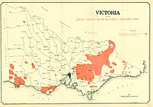
Photo from 2005–06[]

Official inquiries[]
After many major bushfires, state and federal governments have initiated inquiries to see what could be done to address the problem. A parliamentary report from 2010 stated that between 1939 and 2010, there have been at least 18 major bushfire inquiries including state and federal parliamentary committee inquiries, COAG reports, coronial inquiries and Royal Commissions.[104] Another report published in 2015 stated there have been 51 inquiries into wildfires and wildfire management since 1939. The authors noted that Royal Commissions were not the most effective way to learn from past bushfire events.[105] Many of the inquiries into bushfires have recommended "hazard reduction burning"[106] intended to reduce the available fuel and have set targets to burn a certain percentage of forest each year to reduce risk. Planned burns are difficult to do safely and many of the investigations and Royal Commissions have found these targets are seldom met. At the same time, fire management experts disagree on how effective planned burning is.[107]
In January 2020, during the 2019–2020 bushfire season, Prime Minister Scott Morrison raised the prospect of establishing another royal commission, stating in an interview on ABC-TV 7.30 that any inquiry into the crisis would need to be comprehensive and investigate climate change as well as other possible causes.[108] Letters Patent were subsequently issued for the Royal Commission into National Natural Disaster Arrangements on 20 February 2020.[109]
Warnings[]
During the fire season, the Bureau of Meteorology (BOM) provides fire weather forecasts. Fire agencies determine the appropriate Fire Danger Rating by considering the predicted weather including temperature, relative humidity, wind speed and dryness of vegetation. These Fire Danger Ratings are a feature of weather forecasts and alert the community to the actions they should take in preparation for the day. Ratings are broadcast via newspapers, radio, TV, and the internet.[110] But the lastest bushfires that happened in Austrillia were out of the bloom so the pre warnings were not given to the general public as a result when the Fire struck the people has to run from the blazings fire and see their own homes burn down to ash in front of their eyes.[111]
In 2009, a standardized Fire Danger Rating (FDR) was adopted by all Australian states. This included a whole new level – catastrophic fire danger. The first time this level of danger was forecast for Sydney was in November 2019 during the 2019–2020 bushfire season.[112] In 2010, following a national review of the bush fire danger ratings, new trigger points for each rating were introduced for grassland areas in most jurisdictions.
| Category | Fire Danger Index |
|---|---|
| Catastrophic / Code Red | Forest 100+ Grass 150+ |
| Extreme | Forest 75–100 Grass 100–150 |
| Severe | Forest 50–75 Grass 50–100 |
| Very high | 25–50 |
| High | 12–25 |
| Low to moderate | 0–12 |
Remote monitoring[]
Remote monitoring of wildfires is done in Australia. Geoscience Australia developed the (real-time) Sentinel bushfire monitoring system. It uses data from satellites to help fire-fighting agencies assess and manage risks.[113][114][115] There is also MyFireWatch, which is a program based on an existing Department of Fire and Emergency Services (DFES) program, redeveloped by Landgate and Edith Cowan University (ECU) for use by the general public.[116][117] Besides the use of satellites, Australian firefighters also make use of UAV's as a tool for combating fire.[118] Technologist Angus Dorney has observed that "[Australia's] fire services have developed in a largely tech-free environment" and it will be necessary to support cultural change alongside technological solutions if promising technological advances are to live up to their potential.[119]
Regional management[]
The Australasian Fire Authorities Council (AFAC) is the peak body responsible for representing fire, emergency services, and land management agencies in the Australasian region.
Queensland[]
The Rural Fire Service (RFS) is a volunteer-based firefighting agency and operates as part of the Queensland Fire and Emergency Services.[120] Queensland Fire and Rescue are the professional firefighters that fight these fires across Queensland in the cities and the bush.
New South Wales[]
Fire and Rescue NSW (FRNSW), the Forestry Corporation of NSW (FCNSW), the National Parks and Wildlife Service (NPWS) and the New South Wales Rural Fire Service (RFS) work together to manage and respond to fires across New South Wales.
South Australia[]
The Country Fire Service is a volunteer-based fire service in the state of South Australia. The CFS operates as a part of the (SAFECOM).
Victoria[]

In Victoria, the Country Fire Authority (CFA) provides firefighting and other emergency services to country areas and regional townships within the state, as well as large portions of the outer suburban areas and growth corridors of Melbourne not covered by the Metropolitan Fire Brigade.[121]
Responsibility for fire suppression and management, including planned burning on public land such as State Forests and National Parks, which makes up about 7.1 million hectares (18 million acres) or about one-third of the State, sits with the (DELWP).
Western Australia[]
The Department of Fire and Emergency Services (DFES) and the Department of Parks and Wildlife (P&W) have joint responsibility for bushfire management in Western Australia.[122] DFES is an umbrella organization supporting the Fire and Rescue Service (FRS), Bush Fire Service (BFS), Volunteer Fire and Rescue Service (VFRS), State Emergency Service (SES), Volunteer Fire and Emergency Service (VFES), Emergency Services Cadets and the Volunteer Marine Rescue Service (VMR).
Tasmania[]
The Tasmania Fire Service manages bushfires in Tasmania with the help of Tasmanian Parks and Wildlife Service and Forestry Tasmania.[123][124]
Guidelines for survival[]
Local authorities provide education and information for residents in bushfire-prone regions regarding the location of current fires,[125] preservation of life and property[126] and when to escape by car.[127]
Major bushfires in Australia[]
Bushfires have accounted for over 800 deaths in Australia since 1851 and, in 2012, the total accumulated cost was estimated at $1.6 billion.[128] In terms of monetary cost however, they rate behind the damage caused by drought, severe storms, hail, and cyclones,[129] perhaps because they most commonly occur outside highly populated urban areas. However, the severe fires of the summer of 2019–2020 affected densely populated areas including holiday destinations leading NSW Rural Fire Services Commissioner, Shane Fitzsimmons, to claim it was "absolutely" the worst bushfire season on record.[130]
See also[]
- Aerial firefighting and forestry in southern Australia
- AS3959
- List of Australian bushfire seasons
- List of major bushfires in Australia
- List of natural disasters in Australia
- McArthur Forest Fire Danger Index
- Pyrotron, a device designed to help firefighters better understand how to combat the rapid spread of bush fires
- Wildfires in the United States
References[]
- ^ Vandenbeld, John (1988). "The Making Of The Bush: a portrait of the island continent". Nature of Australia. Episode 3. 55 minutes in. ABC TV. Retrieved 12 February 2020.
- ^ a b Tronson, Mark. "Bushfires – across the nation". Christian Today. Retrieved 5 January 2020.
- ^ a b c d e Williams, Liz T. (3 November 2011). "The worst bushfires in Australia's history". Australian Geographic. Retrieved 12 February 2020.
- ^ "New South Wales, December 1974 Bushfire – New South Wales". Australian Institute for Disaster Resilience. Government of Australia. Archived from the original on 13 January 2020. Retrieved 13 January 2020.
During the summer between 1974 and 1975, Australia experienced its worst bushfire season in 30 years. Approximately 15 per cent of Australia's physical land mass sustained extensive fire damage. This equates to roughly around 117 million ha.
- ^ "'Extraordinary' 2019 ends with deadliest day of the worst fire season". The Sydney Morning Herald. 31 December 2019. Retrieved 1 January 2020.
- ^ Readfearn, Graham; Morton, Adam (28 July 2020). "Almost 3 billion animals affected by Australian bushfires, report shows - megafires 'one of the worst wildlife disasters in modern history', say scientists". The Guardian.
- ^ Ross, Monique; Quince, Annabelle (11 January 2020). "The history of fire in Australia — and how it can help us face the bushfires of the future". Rear Vision. ABC Radio National. Retrieved 13 February 2020.
- ^ a b Colton, Schroeder (12 November 2019). "This is Not Normal: Climate Change and Escalating bushfire risk". Australia: Climate Council.
- ^ White, M. E. (1986). The Greening of Gondwana. Frenchs Forest, Australia: Reed Books.
- ^ a b c d Blainey, Geoffrey (2015). The Rise and Fall of Ancient Australia. Penguin Viking.
- ^ "The Fire Book" (PDF). Tangentyre Landcare. 2005. Archived from the original (PDF) on 27 February 2015.
- ^ Flannery, Tim (2002). The Future Eaters: An Ecological History of the Australasian Lands and People. Grove Press.
- ^ Ward, D. J.; Lamont, B. B.; Burrows, C. L. (2001). "Historical role of fire: Grasstrees reveal contrasting fire regimes in eucalypt forest before and after European settlement of southwestern Australia". Forest Ecology and Management (150): 323–329.
- ^ Wilson, Nicholas; Cary, Geoffrey J.; Gibbons, Philip (15 June 2018). "Relationships between mature trees and fire fuel hazard in Australian forest". International Journal of Wildland Fire. 27 (5): 353–362. doi:10.1071/WF17112. hdl:1885/160659.
- ^ "Gamba grass (Andropogon gayanus)". A–Z listing of weeds: Photo guide to weeds. Queensland Department of Primary Industries.
- ^ Head, Lesley; Atchison, Jennifer (2015). "Governing invasive plants: Policy and practice in managing the Gamba grass (Andropogon gayanus) – Bushfire nexus in northern Australia". Land Use Policy. 47 (47): 225–234. doi:10.1016/j.landusepol.2015.04.009.
- ^ a b c "Past bushfires". Forest Fire Management Victoria. Government of Victoria. Retrieved 19 January 2020.
- ^ a b c Cheney, N. P.; CSIRO Division of Forestry (1995). "BUSHFIRES – AN INTEGRAL PART OF AUSTRALIA'S ENVIRONMENT". The Year Book of Australia 1995. Australian Bureau of Statistics. Retrieved 25 January 2020.
- ^ "H.G Wells and the big chill in Canberra's 1939 heatwave". The Sydney Morning Herald. 20 January 2014.
- ^ a b "Lessons learnt (and perhaps forgotten) from Australia's 'worst fires'". The Sydney Morning Herald. 11 January 2019.
- ^ "Bush Fires Over Wide Area". The Argus. 16 January 1939.
- ^ a b c "Terrible Climax to Heatwave". The Sydney Morning Herald. 16 January 1939.
- ^ a b "Report of the Royal Commission: Introduction – Part 1". Victorian Government. 1939 – via Trove, National Library of Australia.
- ^ "Black Friday 1939". Forest Fire Management Victoria. © State of Victoria (Department of Environment, Land, Water and Planning). 27 February 2017. Retrieved 19 January 2020.
 Material was copied from this source, which is available under a Creative Commons Attribution 4.0 International License.
- ^ Cheney, N. P. (1 January 1995). "BUSHFIRES – AN INTEGRAL PART OF AUSTRALIA'S ENVIRONMENT". 1301.0 – Year Book Australia, 1995. Australian Bureau of Statistics. Retrieved 14 January 2020.
In 1974-75 [...] in this season fires burnt over 117 million hectares or 15 per cent of the total land area of this continent.
- ^ "New South Wales, December 1974 Bushfire - New South Wales". Australian Institute for Disaster Resilience. Government of Australia. Archived from the original on 13 January 2020. Retrieved 13 January 2020.
Approximately 15 per cent of Australia's physical land mass sustained extensive fire damage. This equates to roughly around 117 million ha.
- ^ Cole, Brendan (7 January 2020). "WHAT CAUSED THE WILDFIRES IN AUSTRALIA? AMID WORST BLAZES FOR A DECADE, 24 PEOPLE ARE CHARGED WITH ARSON". Newsweek. Archived from the original on 14 February 2020. Retrieved 14 February 2020.
In 1974, 117 million hectares of land was burnt in wildfires in central Australia.
- ^ a b Ellis, Stuart; Kanowski, Peter (2004). National Inquiry on Bushfire Mitigation and Management - 2004. Canberra, Commonwealth of Australia: Council of Australian Governments. pp. 339–345. ISBN 0-646-43442-X. Archived from the original on 13 January 2020. Retrieved 14 February 2020 – via University of Wollongong.
- ^ a b c "Twenty years on since the 1994 fires". Seven News Flashback. New South Wales Rural Fire Service. 6 January 2014.
- ^ "Bushfire threatens homes in Turramurra". The Sydney Morning Herald. 29 December 1993.
- ^ "Thousands flee path of advancing flames". The Sunday Age. 9 January 1994.
- ^ a b "War Diary of a State Ablaze". The Sydney Morning Herald. 15 January 1994.
- ^ Mutton, Sheree (9 January 2014). "Shire fire horror still lingers 20 years on". St George & Sutherland Shire Leader. Retrieved 22 January 2018.
- ^ "A round up of all the fire regions". The Age. 9 January 1994. p. 2.
- ^ "Our History". NSW Rural Fire Service. n.d.
- ^ "Canberra 2003". Australian Disaster Resilience Knowledge Hub. Retrieved 3 November 2019.
- ^ Teague, Bernard; Mcleod, Ronald; Pascoe, Susan (July 2010). "2009 Victorian Bushfires Royal Commission - Final Report Summary" (PDF).
- ^ Nguyen, Kevin; Brunero, Tim; Thomas, Sarah; Keane, Daniel; Mills, Nicole (18 January 2020). "The truth about Australia's fires — arsonists aren't responsible for many this season". ABC News. Australia. Retrieved 15 February 2020.
- ^ RMIT ABC Fact Check; Gordon, Josh (14 January 2020). "Some Coalition MPS say arson is mostly to blame for the bushfire crisis. Here are the facts". ABC News. Australia. Retrieved 15 February 2020.
- ^ Newey, Sarah (2 January 2020). "Australia is burning – but why are the bushfires so bad and is climate change to blame?". The Telegraph. United Kingdom. Archived from the original on 12 January 2022.
- ^ RP, MDM Publishing Ltd- (4 March 2020). "Australia's on fire – what now?". International Fire Fighter. Retrieved 25 February 2021.
- ^ "Fire Behaviour". The Bushfire Foundation. 2020. Retrieved 15 February 2020.
- ^ Drechsel, S., Mayr, G.J. (2008) Objective forecasting of foehn winds for a subgrid-scale alpine valley. Weather and Forecasting, 23, 205–218.
- ^ Sharples, J.J. Mills, G.A., McRae, R.H.D., Weber, R.O. (2010) Elevated fire danger conditions associated with foehn-like winds in southeastern Australia. Journal of Applied Meteorology and Climatology.
- ^ Sharples, J.J., McRae, R.H.D., Weber, R.O., Mills, G.A. (2009) Foehn-like winds and fire danger anomalies in southeastern Australia. Proceedings of the 18th IMACS World Congress and MODSIM09. 13–17 July, Cairns.
- ^ Bonsor, Kevin (29 May 2001). "How Wildfires Work". How Stuff Works. Retrieved 15 February 2020.
- ^ a b c d "Australia bushfires: Which animals typically fare best and worst?". BBC News. 22 November 2019. Retrieved 15 February 2020.
- ^ a b c Abram, Nerilie (31 December 2019). "Australia's Angry Summer: This Is What Climate Change Looks Like". Scientific American. Retrieved 3 January 2019.
- ^ a b "Australia bushfires spew two-thirds of national carbon emissions in one season". Stuff. New Zealand. 3 January 2019.
- ^ Freund, Mandy; Henley, Ben; Allen, Kathryn; Baker, Patrick (2 May 2018). "Recent Australian droughts may be the worst in 800 years". The Conversation. Retrieved 15 February 2020.
- ^ a b c "The Facts about Bushfires and Climate Change". Australia: Climate Council. 13 November 2019.
- ^ Merzian, Richie; Quicke, Audrey; Bennett, Ebony; Campbell, Rod; Swann, Tom (2019). Climate of the Nation (PDF) (Report). The Australia Institute. p. 3.
- ^ a b Readfearn, Graham (13 January 2020). "Explainer: what are the underlying causes of Australia's shocking bushfire season?". Guardian Australia. Retrieved 15 February 2020.
- ^ "Bushfire weather in Southeast Australia: Media Brief" (PDF). The Climate Institute. 26 September 2007. Archived from the original (PDF) on 29 October 2013. Retrieved 24 October 2013.
- ^ Bushfire crisis conditions eight times more likely under 2C warming, analysis shows, The Guardian, 4 March 2020
- ^ "Ten impacts of the Australian bushfires". UNEP. 22 January 2020. Retrieved 25 November 2021.
- ^ National Inventory by Economic Sector 2017. Australia’s National Greenhouse Accounts. Department of the Environment and Energy. August 2019. p. 3.
- ^ "Australian bushfires to contribute to huge annual increase in global carbon dioxide". Guardian Australia. 24 January 2020.
- ^ van der Velde, Ivar R.; van der Werf, Guido R.; Houweling, Sander; Maasakkers, Joannes D.; Borsdorff, Tobias; Landgraf, Jochen; Tol, Paul; van Kempen, Tim A.; van Hees, Richard; Hoogeveen, Ruud; Veefkind, J. Pepijn (September 2021). "Vast CO2 release from Australian fires in 2019–2020 constrained by satellite". Nature. 597 (7876): 366–369. Bibcode:2021Natur.597..366V. doi:10.1038/s41586-021-03712-y. ISSN 1476-4687. PMID 34526704. S2CID 237536364.
- ^ Luke R. H.; McArthur, A. G. (1978). Bushfires in Australia. Canberra: Australian Government Publishing Service.
- ^ Sullivan, Rohan (11 February 2009). "Hot and dry Australia sees wildfire danger rise". The Association Press. Retrieved 13 February 2009.
- ^ "Monsoonal Climate". Questacon. Archived from the original on 20 March 2012. Retrieved 9 September 2006.
- ^ a b c "Bushfire weather". Bureau of Meteorology, Australia. Retrieved 19 January 2020.
- ^ a b "Fire Danger Season Dates". South Australian Country Fire Service. Retrieved 19 January 2020.
- ^ a b "Bush Fire Danger Period and Fire Permits". NSW Rural Fire Service. Retrieved 19 January 2020.
- ^ a b "Restrictions During the Fire Danger Period". Country Fire Association. Retrieved 19 January 2020.
- ^ a b "Central Australian fire season commencement". Northern Territory Government. 4 December 2019. Retrieved 19 January 2020.
- ^ a b "Fire Permit Period Declaration" (PDF). State Fire Commission, Tasmania. Retrieved 19 January 2020.
- ^ a b "Bush Fires Act 1954 – Western Australia". Government of Western Australia. 1954. Retrieved 19 January 2020.
- ^ a b c "Fire management in the NT". Northern Territory Government. Retrieved 19 January 2020.
- ^ Lucas, Chris; Harris, Sarah (10 October 2019). "It's only October, so what's with all these bushfires? New research explains it". The Conversation. Retrieved 20 January 2020.
- ^ "Early start to bushfire season in NSW catches many by surprise". 7:30. Australian Broadcasting Corporation. 9 September 2019. Retrieved 19 January 2020.
- ^ Maunder, Sarah (4 December 2019). "Bushfire season starts early with Gippsland residents urged to prepare after deadly 'practice run'". ABC News. Australia. Retrieved 19 January 2020.
- ^ "Bushfire season could hit Australia early following warmer temperatures". Northern Daily Leader. 12 July 2019. Retrieved 19 January 2020.
- ^ "Bush Fire Danger Period Extended until 30 April 2019". NSW Rural Fire Service. Retrieved 20 January 2020.
- ^ Brown, Carmen (31 October 2013). "Central Australia set for 'average' fire season". ABC News. Australia. Retrieved 20 January 2020.
- ^ "Bushfire season starts early". Southern Highland News. 15 August 2019. Retrieved 20 January 2020.
- ^ "Open Burning". Hawkesbury City Council. Retrieved 20 January 2020.
- ^ "NSW RFS declares start of Bush Fire Danger Period" (Press release). NSW Rural Fore Service. 1 August 2019. Retrieved 19 January 2020.
- ^ "Fire Control Information 2019/20". Waroona Shire Council. Retrieved 19 January 2020.
- ^ "Fire". Donnybrook Belingup Shire. Retrieved 19 January 2020.
- ^ a b Allam, Lorena (18 January 2020). "Right fire for right future: how cultural burning can protect Australia from catastrophic blazes". Guardian Australia. Retrieved 15 February 2020.
- ^ Fuller, Thomas (17 January 2020). "Reducing fire, and cutting carbon emissions, the Aboriginal way". The New York Times. Retrieved 15 February 2020 – via NZ Herald.
- ^ "More than one billion animals killed in Australian bushfires". University of Sydney. 8 January 2020. Retrieved 12 January 2020.
- ^ "A statement about the 480 million animals killed in NSW bushfires since September". University of Sydney. 3 January 2020.
- ^ "Kiwi volunteers helping fire-affected Australian animals". RNZ. 12 January 2020.
- ^ a b "The world loves kangaroos and koalas. Now we are watching them die in droves". Guardian Australia. 6 January 2020.
- ^ "3 billion animals harmed by Australia's fires". World Wildlife Fund. Retrieved 25 November 2021.
- ^ a b Australia strengthens bushfire defences as economic, environmental costs mount, Reuters, 7 January 2020
- ^ a b McCauley, Dana (6 January 2020). "Health impacts of bushfires won't be known for years, experts say". Sydney Morning Herald. Retrieved 15 February 2020.
- ^ Salinger, Jim (8 January 2020). "Australia's bushfires mean New Zealand has become the land of the long pink cloud". Guardian Australia. Retrieved 15 February 2020.
- ^ Lansdown, Sarah; Whyte, Sally (5 January 2020). "Canberra shuts down as smoke smothers city". The Canberra Times. Retrieved 15 February 2020.
- ^ Mao, Frances (24 December 2019). "Australia fires: The thousands of volunteers fighting the flames". BBC News. Retrieved 15 February 2020.
- ^ Fyfe, James; Wilton, James (10 January 2020). "Australia bushfires: Concern over long-term effects on firefighters' health". NewsHub. New Zealand. Retrieved 15 February 2020.
- ^ "Smoke from Australian bushfires was more deadly than the fires themselves". airqualitynews.com. Retrieved 25 November 2021.
- ^ Sim, M. (April 2002). "Bushfires: are we doing enough to reduce the human impact?". Journal of Occupational and Environmental Medicine. 59 (4): 215–216. doi:10.1136/oem.59.4.215. PMC 1740264. PMID 11934947.
- ^ Young, Emma (9 January 2016). "WA fires: deadly Waroona blaze contained but not controlled, downgraded to 'advice'". WA Today.
- ^ "Impacts of Bushfires". Bushfire Front. 2020. Retrieved 13 February 2020.
- ^ Birch, Laura; Lynch, Jacqueline; Ferguson, Holly (22 November 2019). "Rising from the ashes, Yarloop bounces back after devastating bushfires in 2016". ABC News. Australia. Retrieved 13 February 2020.
- ^ Butler, Ben (8 January 2020). "Economic impact of Australia's bushfires set to exceed $4.4bn cost of Black Saturday". Guardian Australia. Retrieved 13 February 2020.
- ^ McDonald, Tim (20 December 2019). "Australia fires: The huge economic cost of Australia's bushfires". BBC News. United Kingdom. Retrieved 15 February 2020.
- ^ Heath, Michael (9 January 2020). "Australian Economy Struck by Wildfires, Setting Up Stimulus". Bloomberg Green. Retrieved 13 February 2020.
- ^ Australia, scheme=AGLSTERMS AglsAgent; corporateName=Reserve Bank of (2020). "Box B: Macroeconomic Effects of the Drought and Bushfires | Statement on Monetary Policy – February 2020". Statement on Monetary Policy (February).
- ^ Senate Select Committee on Agricultural and Related Industries (13 August 2010). Chapter 2 – Previous bushfire inquiries. The incidence and severity of bushfires across Australia. Parliament of Australia. ISBN 978-1-74229-349-3. Retrieved 15 February 2020.
- ^ Eburn, Michael; Hudson, David; Chal, Ignatious; Dovers, Stephen (2 September 2014). Learning from Adversity: What has 75 years of bushfire inquiries (1939–2013) taught us?, Report no 2015.019 (requires download). Research Forum at the Bushfire and Natural Hazards CRC & AFAC conference. Australian National University. Wellington, New Zealand: Bushfire and Natural Hazards CRC. p. 4. Retrieved 15 February 2020.
The fact that catastrophic events continue to recur is evidence either that the community is failing to learn the lessons from the past, or the inquiries fail to identify the true learning – that catastrophic events may be inevitable, or that Royal Commissions are not the most effective way to identify relevant lessons from past events.
- ^ Bonyhady, Nick (21 January 2020). "Prime Minister says hazard reduction burns as important as emissions". Sydney Morning Herald. Retrieved 15 February 2020.
- ^ Mannix, Liam (26 January 2020). "These scientists think we're in a 'bushfire spiral'. They have a plan". Sydney Morning Herald. Retrieved 15 February 2020.
- ^ Morrison, Scott (9 January 2020). "Scott Morrison defends the Government's response to the bushfires" (Streaming video). 7.30 (Interview). Interviewed by Michael Rowland. ABC-TV. Retrieved 15 February 2020.
... there will be a time, I think, to ensure that we work with the states and territories to get the proper inquiry in place. It needs to be comprehensive, it needs to deal with contributing factors which is everything from hazard reduction to climate change through to the response issues, the national coordination matters and, of course, resilience and planning for the future.
- ^ "Commonwealth Letters Patent - 20 February, 2020". Royal Commission into National Natural Disaster Arrangements. Retrieved 15 January 2021.
- ^ "Fire Danger Rating Brochure". Government of Victoria. Country Fire Authority. 2020. Retrieved 15 February 2020.
- ^ "Australia fires: A visual guide to the bushfire crisis". BBC News. 31 January 2020. Retrieved 25 November 2021.
- ^ Cox, Lisa (11 November 2019). "Catastrophic fire danger: what does it mean and what should we do in these conditions?". Guardian Australia. Retrieved 15 February 2020.
- ^ "Real-time bushfire monitoring satellite system to be developed in Australia". ABC News. 11 August 2015.
- ^ "Bushfire tracking with Sentinel Hotspots". www.csiro.au.
- ^ "Sentinel Hotspots". sentinel.ga.gov.au.
- ^ Harradine, Natasha (28 September 2014). "Better bushfire information for regional communities". ABC News.
- ^ "MyFireWatch – Bushfire map information Australia". myfirewatch.landgate.wa.gov.au.
- ^ "Drones to assist firefighters in emergencies". NSW Government.
- ^ Dorney, Angus (21 November 2021). "Fire Tech is Good But Mind the Gap". The Australian.
- ^ "Rural Fire Service Queensland".
- ^ "Country Fire Authority". Retrieved 30 October 2010.
- ^ "Welcome to DFES". Department of Fire and Emergency Services of Western Australia. Retrieved 30 October 2010.
- ^ "About TFS". Tasmania Fire Service. 2019.
- ^ 2013 Tasmanian Bushfires Inquiry: Volume 1 (PDF) (Report). ISBN 978-0-9923581-0-5.
- ^ "NSW Current Fires". NSW Rural Fire Service.
- ^ "How to survive a bushfire" (PDF). NSW Rural Fire Service. Retrieved 20 February 2017.
- ^ "Driving in a bushfire". 13 February 2017. Retrieved 20 February 2017.
- ^ "Summary of Major Bush Fires in Australia Since 1851". Romsey Australia. Retrieved 29 October 2010.
- ^ "EMA Disasters Database". Emergency management Australia. Archived from the original on 18 November 2010. Retrieved 30 October 2010.
- ^ Alexander, Harriet; Chung, Laura; Chrysanthos, Natassia; Drevikovsky, Janek; Brickwood, James (1 January 2020). "'Extraordinary' 2019 ends with deadliest day of the worst fire season". The Sydney Morning Herald.
- Australia Fires: A Visual Guide to the Bushfire Crisis BBC News, BBC, 31 January 2020
External links[]
| Wikimedia Commons has media related to Bushfires in Australia. |
- Bureau of Meteorology
- EarthWindMap – Current global map of airborne particulates less than 1 micrometre in diameter, including smoke, and hotspots, centred on Australia
- Bushfires in Australia
- Climate change in Australia