Byurakan
Byurakan
Բյուրական | |
|---|---|
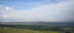 View of Byurakan as seen from the village of Tegher | |
 Byurakan | |
| Coordinates: 40°20′24″N 44°16′13″E / 40.34000°N 44.27028°ECoordinates: 40°20′24″N 44°16′13″E / 40.34000°N 44.27028°E | |
| Country | Armenia |
| Marz (Province) | Aragatsotn |
| Government | |
| • Mayor | Zarzand Babayan |
| Area | |
| • Total | 21.27 km2 (8.21 sq mi) |
| Elevation | 1,460 m (4,790 ft) |
| Population (2011) | |
| • Total | 4,345 |
| Time zone | UTC+4 ( ) |

Byurakan (Armenian: Բյուրական), is a major village in the Aragatsotn Province of Armenia, located on the slope of Mount Aragats. The village is home to several historical sites including the 7th-century Artavazik Church, the 10th-century basilica of Saint Hovhannes and a huge 13th-century khachkar monument.
It is also home to the Byurakan Observatory.
Byurakan Observatory[]
Byurakan observatory is founded in 1946 by Viktor Hambardzumyan, Armenian scientist. There are several telescopes. The diameter of the biggest telescope is 2.6m (the biggest telescope in Caucasus). There is also 1m Shmidt telescope.
Gallery[]
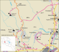
Road map of Byurakan and surrounding region.

Basilica of S. Hovhannes of the 10th century

Artavazik Church of the 7th century with huge khachkar monument behind.
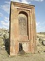
Huge khachkar monument behind Artavazik Church of the 13th century

Pillar style khachkar with a Maltese Cross located behind a house in the village.


Nearby sites[]
Towns[]
Villages[]
Historical sites[]
- Amberd fortress
See also[]
References[]
- Byurakan at GEOnet Names Server
- World Gazetteer: Armenia[dead link] – World-Gazetteer.com
- Report of the results of the 2001 Armenian Census
- Kiesling, Rediscovering Armenia, p. 15, available online at the US embassy to Armenia's website
| show Authority control |
|---|
This article about a location in Aragatsotn Province, Armenia is a stub. You can help Wikipedia by . |

- Populated places in Aragatsotn Province
- Aragatsotn geography stubs