Cárdenas, Tabasco
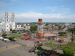
Panoramic view of the Independencia park in the city of Heroica Cárdenas, Tabasco state, Mexico.
Cárdenas is the second-largest city in the state of Tabasco, in southeastern Mexico. It lies in the northwestern part of the state, on the Gulf of Mexico coast, east of the city of Coatzacoalcos, Veracruz. The city is the municipal seat of Cárdenas Municipality. At the census of 2005 the city had a population of 79,875 inhabitants, while the municipality had 219,563 inhabitants. There are numerous smaller communities in the municipality, but the largest are Sánchez Magallanes and . The area of the municipality is 2,112 km² (815.45 sq mi).
Climate[]
| hideClimate data for Cardenas | |||||||||||||
|---|---|---|---|---|---|---|---|---|---|---|---|---|---|
| Month | Jan | Feb | Mar | Apr | May | Jun | Jul | Aug | Sep | Oct | Nov | Dec | Year |
| Average high °C (°F) | 27.6 (81.7) |
29 (84) |
31.9 (89.4) |
34.3 (93.7) |
35.3 (95.5) |
34.3 (93.7) |
33.5 (92.3) |
33.5 (92.3) |
32.6 (90.7) |
31.0 (87.8) |
29.4 (84.9) |
28.0 (82.4) |
31.7 (89.1) |
| Average low °C (°F) | 18.2 (64.8) |
18.5 (65.3) |
19.9 (67.8) |
21.7 (71.1) |
23 (73) |
23 (73) |
22.5 (72.5) |
22.5 (72.5) |
22.4 (72.3) |
21.7 (71.1) |
20 (68) |
18.8 (65.8) |
21.0 (69.8) |
| Average precipitation mm (inches) | 140 (5.4) |
91 (3.6) |
43 (1.7) |
51 (2) |
69 (2.7) |
220 (8.6) |
170 (6.8) |
230 (9.1) |
340 (13.3) |
350 (13.8) |
210 (8.4) |
140 (5.4) |
2,050 (80.8) |
| Source: Weatherbase [1] | |||||||||||||
References[]
- Link to tables of population data from Census of 2005 INEGI: Instituto Nacional de Estadística, Geografía e Informática
- Tabasco Enciclopedia de los Municipios de México
- ^ "Weatherbase: Historical Weather for Cardenas, Tabasco". Weatherbase. 2011. Retrieved on November 24, 2011.
External links[]
- Ayuntamiento de Cárdenas Official website
| show |
|---|

| show Authority control |
|---|
Coordinates: 17°58′59″N 93°22′01″W / 17.983°N 93.367°W

Categories:
- Populated places in Tabasco
- Southern Mexico geography stubs