Cávado River
This article does not cite any sources. (January 2011) |
The Cávado River (Portuguese: rio Cávado; Portuguese pronunciation: [ˈʁiu ˈkavɐðu]) is a river located in northern Portugal.
It has its source in at an elevation of 1,520 metres (4,990 ft) above sea level. It runs 135 kilometres (84 mi) from Fonte da Pipa, near the triangulation station Larouco, to its mouth into the Atlantic Ocean next to the city of Esposende. It flows through the districts of Vila Real and Braga, in Cávado Region, and flows near the towns of Vila Verde and Esposende and cities of Braga and Barcelos.
Its tributaries are the , and .
Dams and Reservoirs[]
Beginning at the headwaters, there are 5 dams on the Cávado:
| Dam | Nameplate capacity (MW) | Reservoir | Surface area (km²) | Total capacity (Mio. m³) |
|---|---|---|---|---|
| Alto Cávado | 0.5 | 3.3 | ||
| 54 | Paradela | 3.8 | 164.4 | |
| Salamonde | 42 | Salamonde | 2.42 | 65 |
| Caniçada | 60 | Caniçada | 6.89 | 170.6 |
| 4.8 | Caniçada | 0.69 | 0.5 |
| Wikimedia Commons has media related to Cávado River. |
Gallery[]

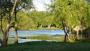
Cávado in Palmeira Braga
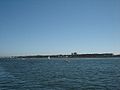
Mouth in Esposende


Coordinates: 41°32′28″N 08°47′36″W / 41.54111°N 8.79333°W

| hide Authority control | |
|---|---|
| General | |
| National libraries | |
| Other | |
Categories:
- Cávado River
- Portugal river stubs