Côte-Nord-du-Golfe-du-Saint-Laurent
Côte-Nord-du-Golfe-du-Saint-Laurent | |
|---|---|
Municipality | |
 The village of Harrington Harbour | |
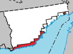 Location within Le Golfe-du-Saint-Laurent RCM. | |
 Côte-Nord-du-Golfe-du-Saint-Laurent Location in Côte-Nord Region of Quebec. | |
| Coordinates: 50°28′N 59°36′W / 50.467°N 59.600°WCoordinates: 50°28′N 59°36′W / 50.467°N 59.600°W[1] | |
| Country | |
| Province | |
| Region | Côte-Nord |
| RCM | Le Golfe-du-Saint-Laurent |
| Constituted | June 22, 1963 |
| Government | |
| • Administrator | Jacques Lareau (p.i.) |
| • Federal riding | Manicouagan |
| • Prov. riding | Duplessis |
| Area | |
| • Total | 3,070.30 km2 (1,185.45 sq mi) |
| • Land | 2,845.04 km2 (1,098.48 sq mi) |
| Population (2011)[3] | |
| • Total | 971 |
| • Density | 0.3/km2 (0.8/sq mi) |
| • Pop 2006-2011 | |
| • Dwellings | 471 |
| Time zone | UTC-4 (AST) |
| Postal code(s) | G0G 1G0 |
| Area code(s) | 418 and 581 |
| Highways | |

Côte-Nord-du-Golfe-du-Saint-Laurent is a municipality in the regional county municipality of Le Golfe-du-Saint-Laurent in the Côte-Nord region of the province of Quebec, Canada. The municipality consists of two non-contiguous areas, both along the shores of the Gulf of Saint Lawrence. The larger main part stretches from the Natashquan River to the Gros Mécatina River and includes all populated places. The eastern part is a small section between Middle Bay and Brador.
History[]
The Municipality of Côte-Nord-du-Golfe-Saint-Laurent was incorporated in 1963 and originally extended along the shores of the Saint Lawrence from the Natashquan River to the Newfoundland and Labrador provincial border, some 5,240 square kilometres (2,020 sq mi) roughly corresponding to the Basse-Côte-Nord territory. However, with an isolated population scattered over a large area devoid of roads, the municipality did not have an elected municipal council and was managed by an appointed administrator headquartered in Chevery.[1]
Starting in 1990, a restructuring plan was enacted that would carve up Côte-Nord-du-Golfe-Saint-Laurent into several additional municipalities. That year, the municipalities of Bonne-Espérance and Blanc-Sablon were formed, followed by the Municipality of Saint-Augustin on December 30, 1992, and finally the municipality of Gros-Mécatina on December 22, 1993.[1]
On May 8, 1996, the municipality's name was officially adjusted to Côte-Nord-du-Golfe-du-Saint-Laurent.[1]
Communities[]
The municipality includes the communities of Chevery, Harrington Harbour, Kegaska, and Tête-à-la-Baleine.
It also includes the following abandoned settlements and ghost towns, in order from west to east: Musquaro, Wolf Bay, Aylmer Sound, Ettamiau, Pointe Amouri, Barachois, Chez Menneau, and Boulet's (also known as Bully's).
Chevery[]
Chevery (50°28′07″N 59°36′58″W / 50.46861°N 59.61611°W) is the administrative centre of the municipality, located at the mouth of the Nétagamiou River. Its population in the Canada 2011 Census was 251.
Harrington Harbour[]
Harrington Harbour (50°30′00″N 59°28′47″W / 50.50000°N 59.47972°W) was founded near the end of the 19th century by fishermen from Newfoundland.[4] The primary activity is commercial fishing for crabs, lobster, turbot, halibut, cod, and lumpfish. Its population in the Canada 2011 Census was 261.
Kegaska[]
Kegaska (50°11′01″N 61°16′21″W / 50.18361°N 61.27250°W) is the westernmost community in the municipality. Its population in the Canada 2011 Census was 138, mostly anglophone settlers from Anticosti Island.
Tête-à-la-Baleine[]
Tête-à-la-Baleine (50°42′10″N 59°19′23″W / 50.70278°N 59.32306°W), occasionally known as Whale Head in English, was settled in the 19th century after Michael Kenty bought the local trading post from the Labrador Company. Its population in the Canada 2011 Census was 129.
Musquaro[]
The ghost town of Musquaro (50°12′58″N 61°03′50″W / 50.21611°N 61.06389°W) is at the mouth of the Musquaro River, between Kegaska and La Romaine. Identified as Mascoüarou on Louis Jolliet's map of 1694, the name went through numerous spelling changes, such as Nasquirou, Maskouaro, and Mahkuanu. Its root meaning is "black bear tail" and may refer to the foothills of Mount Mascoüarou as shown Jolliet's map.[5]
It was the site of a fortified trading post, established in 1710, and a catholic mission. In 1780, the post was on the territory granted to the Labrador Company of Quebec. 23 years later, the franchise went to the North West Company which in turn was sold to the Hudson's Bay Company in 1821. Closed for a brief time in 1859, the post remained occupied until 1925 after which it closed permanently.[5]
Demographics[]
Population[]
| hideCanada census – Côte-Nord-du-Golfe-du-Saint-Laurent community profile | |||
|---|---|---|---|
| 2011 | 2006 | ||
| Population: | 971 (-5.5% from 2006) | 1,028 (-13.1% from 2001) | |
| Land area: | 2,845.04 km2 (1,098.48 sq mi) | 2,845.43 km2 (1,098.63 sq mi) | |
| Population density: | 0.3/km2 (0.78/sq mi) | 0.4/km2 (1.0/sq mi) | |
| Median age: | 46.3 (M: 46.7, F: 45.7) | 41.7 (M: 41.7, F: 41.6) | |
| Total private dwellings: | 471 | 447 | |
| Median household income: | $.N/A | $46,919 | |
| Notes: 2011 income data for this area has been suppressed for data quality or confidentiality reasons. – References: 2011[6] 2006[7] earlier[8] | |||
| Year | Pop. | ±% |
|---|---|---|
| 1991 | 1,322 | — |
| 1996 | 1,214 | −8.2% |
| 2001 | 1,183 | −2.6% |
| 2006 | 1,028 | −13.1% |
| 2011 | 971 | −5.5% |
Language[]
| Canada Census Mother Tongue - Côte-Nord-du-Golfe-du-Saint-Laurent, Quebec[9] | ||||||||||||||||||
|---|---|---|---|---|---|---|---|---|---|---|---|---|---|---|---|---|---|---|
| Census | Total | French
|
English
|
French & English
|
Other
| |||||||||||||
| Year | Responses | Count | Trend | Pop % | Count | Trend | Pop % | Count | Trend | Pop % | Count | Trend | Pop % | |||||
2011
|
955
|
320 | 33.51% | 610 | 63.87% | 20 | 2.09% | 5 | 0.52% | |||||||||
2006
|
1,015
|
295 | 29.06% | 710 | 69.95% | 10 | 0.99% | 0 | 0.00% | |||||||||
2001
|
1,165
|
380 | 32.62% | 770 | 66.09% | 15 | 1.29% | 0 | 0.00% | |||||||||
1996
|
1,190
|
415 | n/a | 34.87% | 750 | n/a | 63.03% | 25 | n/a | 2.10% | 0 | n/a | 0.00% | |||||
Transportation[]
The municipality is served by three small local airports, Chevery Airport, Kegaska Airport and Tête-à-la-Baleine Airport. Harrington Harbour is served by a heliport, but does not have its own full airport.
Harrington Harbour is located on a small island which has no cars or roads, and all transportation in the community is by bicycle. Each mainland community has local road access — however, no roads currently connect one community to another, the entire municipality is isolated from the provincial highway network, and ferries or taxi boats must be used to travel between the communities or to the rest of the province.
In recent years the municipality has lobbied for Highway 138, which currently ends at Kégaska, to be extended through the area. The provincial government has announced a feasibility study, although no construction schedule has been announced to date.[10]
Climate[]
Although located at the same latitude as Cornwall or Vancouver, the cold Labrador Current gives Côte-Nord-du-Golfe-du-Saint-Laurent a subarctic climate (Köppen Dfc), a little short of a humid continental climate (Dfb). Winters are cold and very snowy due to the influence of the Icelandic Low to the east, with mean snowfall averaging 2.94 metres (115.7 in) and extreme cover of 2.00 metres or 78.74 inches on 10 March 1994. In summer, maritime includes is much more pronounced than in winter and cools average July temperatures by about 5 °C (9.0 °F) compared to inland cities like Regina or Winnipeg.
| hideClimate data for Tête-à-la-Baleine | |||||||||||||
|---|---|---|---|---|---|---|---|---|---|---|---|---|---|
| Month | Jan | Feb | Mar | Apr | May | Jun | Jul | Aug | Sep | Oct | Nov | Dec | Year |
| Record high °C (°F) | 6.1 (43.0) |
6.1 (43.0) |
15 (59) |
12.8 (55.0) |
21 (70) |
32.8 (91.0) |
31.7 (89.1) |
30 (86) |
28.9 (84.0) |
20.6 (69.1) |
16.1 (61.0) |
8.9 (48.0) |
32.8 (91.0) |
| Average high °C (°F) | −8.3 (17.1) |
−7.1 (19.2) |
−1.8 (28.8) |
3.3 (37.9) |
8.8 (47.8) |
14.4 (57.9) |
18.8 (65.8) |
18.7 (65.7) |
14.5 (58.1) |
8.3 (46.9) |
2.1 (35.8) |
−5.2 (22.6) |
5.6 (42.1) |
| Daily mean °C (°F) | −14 (7) |
−12.9 (8.8) |
−7.2 (19.0) |
−0.7 (30.7) |
4.6 (40.3) |
9.7 (49.5) |
14 (57) |
13.9 (57.0) |
9.8 (49.6) |
4.1 (39.4) |
−1.6 (29.1) |
−10.1 (13.8) |
0.8 (33.4) |
| Average low °C (°F) | −19.6 (−3.3) |
−18.6 (−1.5) |
−12.5 (9.5) |
−4.7 (23.5) |
0.4 (32.7) |
4.9 (40.8) |
9.1 (48.4) |
9.1 (48.4) |
5.1 (41.2) |
−0.1 (31.8) |
−5.4 (22.3) |
−14.9 (5.2) |
−3.9 (25.0) |
| Record low °C (°F) | −38.9 (−38.0) |
−39.5 (−39.1) |
−35 (−31) |
−27 (−17) |
−13.3 (8.1) |
−2.8 (27.0) |
−0.6 (30.9) |
−1.1 (30.0) |
−5 (23) |
−14.4 (6.1) |
−22.2 (−8.0) |
−35.6 (−32.1) |
−39.5 (−39.1) |
| Average precipitation mm (inches) | 78.1 (3.07) |
52.6 (2.07) |
73.1 (2.88) |
78.5 (3.09) |
97.7 (3.85) |
112.1 (4.41) |
111.4 (4.39) |
111.9 (4.41) |
128.3 (5.05) |
129.9 (5.11) |
116.9 (4.60) |
102.8 (4.05) |
1,193.3 (46.98) |
| Average rainfall mm (inches) | 19.5 (0.77) |
7.3 (0.29) |
25.9 (1.02) |
47.2 (1.86) |
92.3 (3.63) |
111.7 (4.40) |
111.4 (4.39) |
111.9 (4.41) |
128.3 (5.05) |
124.6 (4.91) |
85.4 (3.36) |
33.3 (1.31) |
898.8 (35.4) |
| Average snowfall cm (inches) | 58.6 (23.1) |
45.3 (17.8) |
47.2 (18.6) |
31.4 (12.4) |
5.4 (2.1) |
0.4 (0.2) |
0.0 (0.0) |
0.0 (0.0) |
0.0 (0.0) |
5.2 (2.0) |
31.5 (12.4) |
69.5 (27.4) |
294.5 (116) |
| Average precipitation days (≥ 0.2 mm) | 9.7 | 7.2 | 8.2 | 8.0 | 8.6 | 8.8 | 9.0 | 9.4 | 10.3 | 10.5 | 9.8 | 10.8 | 110.3 |
| Average rainy days (≥ 0.2 mm) | 1.6 | 0.8 | 1.8 | 4.0 | 7.9 | 8.8 | 9.0 | 9.4 | 10.3 | 9.9 | 5.8 | 2.4 | 71.7 |
| Average snowy days (≥ 0.2 cm) | 8.4 | 6.6 | 6.7 | 4.1 | 0.9 | 0.0 | 0.0 | 0.0 | 0.0 | 0.8 | 4.5 | 8.7 | 40.7 |
| Source: Environment Canada[11] | |||||||||||||
Media[]
Two community radio stations, CFTH-FM-1 in Harrington Harbour and CJTB-FM in Tête-à-la-Baleine, operate in the municipality. CFTH also has rebroadcasters in Kegaska and Mutton Bay. The municipality is also served by rebroadcasters of Première Chaîne's CBSI-FM in Harrington Harbour and Tête-à-la-Baleine, and by a rebroadcaster of CBC Radio One's CBVE-FM in Harrington Harbour.
Télévision de Radio-Canada's CJBR-TV has rebroadcasters in Harrington Harbour and Tête-à-la-Baleine, and CBC Television's CBMT has a rebroadcaster in Harrington Harbour. The municipality does not receive any of Canada's commercial broadcast television networks, English or French, over the air.
Education[]
Commission scolaire du Littoral operates:[12]
- (anglophone and francophone) - Chevery
- (francophone) - Tête-à-la-Baleine
- Harrington School (anglophone) - Harrington Harbour
- Kegaska School (anglophone) - Kegaska
- Marie-Sarah School for adults - La Romaine
See also[]
References[]
- ^ Jump up to: a b c d "Côte-Nord-du-Golfe-du-Saint-Laurent (Municipalité)" (in French). Commission de toponymie du Québec. Retrieved 2010-09-21.
- ^ Jump up to: a b "Côte-Nord-du-Golfe-du-Saint-Laurent". Répertoire des municipalités (in French). Ministère des Affaires municipales, des Régions et de l'Occupation du territoire. Archived from the original on 2013-02-18. Retrieved 2012-04-04.
- ^ Jump up to: a b "Côte-Nord-du-Golfe-du-Saint-Laurent census profile". 2011 Census of Population. Statistics Canada. Retrieved 2012-04-04.
- ^ Tourism Lower North Shore: Harrington Harbour
- ^ Jump up to: a b "Musquaro (hameau)" (in French). Commission de toponymie du Québec. Retrieved 2010-09-21.
- ^ "2011 Community Profiles". 2011 Canadian Census. Statistics Canada. July 5, 2013. Retrieved 2014-01-30.
- ^ "2006 Community Profiles". 2006 Canadian Census. Statistics Canada. March 30, 2011. Retrieved 2011-04-29.
- ^ "2001 Community Profiles". 2001 Canadian Census. Statistics Canada. February 17, 2012.
- ^ Jump up to: a b Statistics Canada: 1996, 2001, 2006, 2011 census
- ^ "New Quebec highway good for Labrador economy: exporter". CBC News. 2006-08-25. Retrieved 2007-08-17.
- ^ Environment Canada — Canadian Climate Normals 1971–2000. Retrieved 23 January 2010.
- ^ Jump up to: a b "Schools and centers." Commission scolaire du Littoral. Retrieved on September 23, 2017.
- ^ "Marie-Sarah's news - La Romaine." Commission scolaire du Littoral. Retrieved on September 23, 2017.
External links[]
| Wikimedia Commons has media related to Côte-Nord-du-Golfe-du-Saint-Laurent. |
| show Adjacent Municipal Subdivisions - Western section |
|---|
| show Adjacent Municipal Subdivisions - Eastern section |
|---|
| hide | |||||
|---|---|---|---|---|---|
| Administrative units |
| ||||
| Protected areas | |||||
| Major river basins | |||||
| Significant lakes | |||||
| Airports | |||||
| Roads | |||||
| |||||
| show Authority control |
|---|
- Municipalities in Quebec
- Incorporated places in Côte-Nord