Cameron, Arizona
Cameron, Arizona | |
|---|---|
 Cameron historic marker | |
 Cameron, Arizona Location in the United States | |
| Coordinates: 35°52′30″N 111°24′48″W / 35.87500°N 111.41333°WCoordinates: 35°52′30″N 111°24′48″W / 35.87500°N 111.41333°W | |
| Country | United States |
| State | Arizona |
| County | Coconino |
| Area | |
| • Total | 18.74 sq mi (48.54 km2) |
| • Land | 18.72 sq mi (48.50 km2) |
| • Water | 0.02 sq mi (0.04 km2) |
| Elevation | 4,202 ft (1,281 m) |
| Population (2020) | |
| • Total | 734 |
| • Density | 39.20/sq mi (15.14/km2) |
| Time zone | UTC-7 (MST) |
| • Summer (DST) | UTC-6 (MDT) |
| ZIP codes | 86016, 86020 |
| Area code | 928 |
| FIPS code | 04-09340 |
| GNIS feature ID | 2396 |


Cameron (Navajo: Naʼníʼá Hasání) is a census-designated place (CDP) in Coconino County, Arizona, United States. The population was 885 at the 2010 census.[2] Most of the town's economy is tourist food and craft stalls, restaurants, and other services for north–south traffic from Flagstaff and Page. There is a ranger station supplying information and hiking permits for the Navajo Nation as well as a small selection of books for sale. There is also a large craft store run by the Nation itself; most vendors in the area operate from small private stalls. It is named after Ralph H. Cameron, Arizona's first senator.
Geography[]
Cameron is located at 35°51′19″N 111°25′17″W / 35.85528°N 111.42139°W (35.855410, -111.421465)[3] on the Navajo Nation. Elevation is 4,216 feet (1,285 m) above sea level. It is immediately south of the Little Colorado River, just above the beginning of the Little Colorado River Gorge and the stream's descent into the Grand Canyon. Cameron lies at the intersection of US 89 and State Route 64, not far from the Desert View entrance to Grand Canyon National Park.
According to the United States Census Bureau, the CDP has a total area of 18.7 square miles (48.5 km2), of which 0.02 square miles (0.04 km2) is water.[4]
Demographics[]
| Languages (2000) [5] | Percent |
|---|---|
| Spoke Navajo at home | 70% |
| Spoke English at home | 30% |
| Historical population | |||
|---|---|---|---|
| Census | Pop. | %± | |
| 2020 | 734 | — | |
| U.S. Decennial Census[6] | |||
As of the census[7] of 2000, there were 978 people, 236 households, and 194 families residing in the CDP. The population density was 53.0 people per square mile (20.5/km2). There were 317 housing units at an average density of 17.2/sq mi (6.6/km2). The racial makeup of the CDP was 94.7% Native American, 1.7% White, 0.1% Black or African American, 0.1% Asian, 0.8% from other races, and 2.6% from two or more races. 4.1% of the population were Hispanic or Latino of any race.
There were 236 households, out of which 44.5% had children under the age of 18 living with them, 47.9% were married couples living together, 28.4% had a female householder with no husband present, and 17.4% were non-families. 15.7% of all households were made up of individuals, and 4.2% had someone living alone who was 65 years of age or older. The average household size was 4.14 and the average family size was 4.61.
In the CDP, the age distribution of the population shows 41.2% under the age of 18, 10.9% from 18 to 24, 27.5% from 25 to 44, 13.7% from 45 to 64, and 6.6% who were 65 years of age or older. The median age was 24 years. For every 100 females, there were 105.0 males. For every 100 females age 18 and over, there were 91.7 males.
The median income for a household in the CDP was $24,773, and the median income for a family was $21,420. Males had a median income of $21,786 versus $12,614 for females. The per capita income for the CDP was $5,970. About 38.0% of families and 36.5% of the population were below the poverty line, including 42.0% of those under age 18 and 52.8% of those age 65 or over.
Education[]
The area is served by the Tuba City Unified School District.[8] The community has one elementary school called Dzil Libei Elementary School, which is a K–6 grade school serving the community. There is also a local preschool run by the Navajo Nation.
Tuba City High School and Tuba City Elementary School serve Cameron.
Images of historic Cameron, Arizona[]
| Part of a series of the |
| Cities, towns and CDPs in Arizona with lists and images of historic properties, forts, cemeteries or historic districts |
|---|
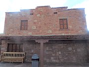
Pictured are some of the structures of Cameron, as they looked in 2019. Also, included is a short description of the structures pictured.
- Tanner's Crossing Bridge – A suspension bridge built in 1911, by the Midland Bridge Co. for the Office of Indian Affairs. The one track suspension bridge was erected over a gorge of the Little Colorado River. The bridge, which was bypassed 1959, was named after Seth Tanner, a Mormon prospector from Tuba City, Arizona. It was listed in the National Register of Historic Places on June 5, 1986, reference: #86001206. [9]
- Cameron Trading Post – The trading post, first known as the "Little Colorado Trading Post", was established by the brothers Hubert and C.D. Richardson in 1913. The post was later changed to the Cameron Trading Post in honor of Arizona Senator Ralph Cameron.[10]
- The Grand Canyon Hotel – Sometimes referred to as the "Grand Canyon Motel", was built in 1928 and is still operating as such.
- The Cameron Post Office – Established in 1916.
- The Cameron Trading Post Warehouse – built in 1916.
- A Navajo Swtloghome – A Navajo Swtloghome is a three-bedroom, two-bath 1,810-square-foot log cabin.[11]


Cameron Trading Post – 1916

Cameron Trading Post – 1916

Grand Canyon Hotel (now the Grand Canyon Motel) – 1928

Cameron Post Office-1916
Tradiing Post Warehouse – 1916

Tanner's Suspension Bridge – 1911

U.S. Route 89 crossing bridge next to the Cameron trading post.
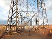
Different view of Tanner's Suspension Bridge.

Navajo Modern Hogan Swtloghomes.


See also[]
References[]
- ^ "2020 U.S. Gazetteer Files". United States Census Bureau. Retrieved October 29, 2021.
- ^ "Profile of General Population and Housing Characteristics: 2010 Demographic Profile Data (DP-1): Cameron CDP, Arizona". United States Census Bureau. Retrieved December 8, 2011.
- ^ "US Gazetteer files: 2010, 2000, and 1990". United States Census Bureau. 2011-02-12. Retrieved 2011-04-23.
- ^ "Geographic Identifiers: 2010 Demographic Profile Data (G001): Cameron CDP, Arizona". United States Census Bureau. Retrieved December 8, 2011.
- ^ "Data Center Results".
- ^ "Census of Population and Housing". Census.gov. Retrieved June 4, 2016.
- ^ "U.S. Census website". United States Census Bureau. Retrieved 2008-01-31.
- ^ "2020 Census – School District Reference Map: Coconino County, AZ" (PDF). U.S. Census Bureau. Retrieved 2021-07-30.
- ^ Historic Tanner's Bridge
- ^ Cameron Trading Post
- ^ Honest Abe's Log Cabins
External links[]
| Wikimedia Commons has media related to Cameron, Arizona. |
- U.S. Geological Survey Geographic Names Information System: Cameron
- U.S. Geological Survey Geographic Names Information System: Cameron Census Designated Place

| Tónaneezdizí (Western Agency) |
|
|---|---|
| Chʼínílį́ (Chinle Agency) |
|
| Tséhootsooí (Fort Defiance Agency) |
|
| Naatʼáaniinééz (Shiprock Agency) |
|
| Tʼiistsʼózí (Eastern Agency) |
|
- Census-designated places in Coconino County, Arizona
- Populated places on the Navajo Nation