Camp Richardson, California
Coordinates: 38°56′04″N 120°02′25″W / 38.93444°N 120.04028°W

Camp Richardson | |
|---|---|
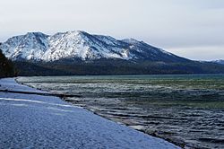 Beach at Camp Richardson | |
 Camp Richardson Location in California | |
| Coordinates: 38°56′04″N 120°02′25″W / 38.93444°N 120.04028°W | |
| Country | United States |
| State | California |
| County | El Dorado County |
| Elevation | 6,250 ft (1,905 m) |
| Population (2010) | |
| • Total | 13 |

Camp Richardson is an unincorporated community at Lake Tahoe, in El Dorado County, California.[1] It lies at an elevation of 6250 feet (1905 m) in the Sierra Nevada.[1]
A post office operated at Camp Richardson from 1927 to 1973, with a closure from 1964 to 1965.[2] The place is named after its first postmaster, Alonzo L. Richardson.[2] A USGS topographic map from 1891 shows Camp Richardson used to be called Yanks.[3]
References[]
- ^ a b c U.S. Geological Survey Geographic Names Information System: Camp Richardson, California
- ^ a b Durham, David L. (1998). California's Geographic Names: A Gazetteer of Historic and Modern Names of the State. Clovis, Calif.: Word Dancer Press. p. 460. ISBN 1-884995-14-4.
- ^ United States Geological Survey (1891). Pyramid Peak Sheet (JPEG) (Topographic map). 1:125,000. Reston, VA: United States Geological Survey. Retrieved July 17, 2018.
Municipalities and communities of El Dorado County, California, United States | ||
|---|---|---|
| Cities |  | |
| CDPs | ||
| Unincorporated communities |
| |
| Former settlements | ||
| Footnotes | ‡This CDP also has portions in an adjacent county or counties | |
| ||
This El Dorado County, California–related article is a stub. You can help Wikipedia by . |
Categories:
- Lake Tahoe
- Unincorporated communities in El Dorado County, California
- Unincorporated communities in California
- El Dorado County, California geography stubs