Canadice Lake
| Canadice Lake | |
|---|---|
 Aerial view of Canadice Lake in fall 2006. | |
 Canadice Lake Location within New York | |
| Location | Canadice, New York |
| Group | Finger Lakes |
| Coordinates | 42°43′00″N 77°34′04″W / 42.71667°N 77.56778°WCoordinates: 42°43′00″N 77°34′04″W / 42.71667°N 77.56778°W |
| Type | Ground moraine |
| Primary outflows | Canadice Outlet |
| Basin countries | United States |
| Max. length | 3 mi (4.8 km) |
| Max. width | 0.3 mi (0.48 km) |
| Surface area | 649 acres (2.63 km2) |
| Average depth | 55 ft (17 m) |
| Max. depth | 95 ft (29 m) |
| Water volume | .011 cu mi (0.046 km3) |
| Shore length1 | 6.5 mi (10.5 km) |
| Surface elevation | 1,096 ft (334 m)[1] |
| 1 Shore length is not a well-defined measure. | |


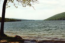
Canadice Lake /ˈkænədaɪs/ is the smallest Finger Lake of western New York. The lake is located approximately 30 miles (48 km) south of Rochester. The name is derived from the Iroquois word ska-ne-a-dice, meaning long lake.[2]
Description[]
Canadice Lake is three miles (4.8 km) long and 0.3 miles (0.48 km) wide at its widest point. The lake has a surface area of 649 acres (2.63 km2) and a maximum depth of 95 feet (29 m).[3] Its shoreline is 6.5 miles (10.5 km) long.[citation needed]
The lake is used as a water source of Rochester, New York. To protect the water quality, no houses are permitted on its shore and boats are limited to 17 feet (5.2 m) in length and a must have a 10-horsepower engine or less. Swimming, camping and contamination of the water are prohibited.[3] Previously, a free permit was required to fish or boat on the lake, but that permit system has been discontinued and they are no longer required.[4]
Recreation[]
Canadice Lake features several trout species for recreational fishing, including lake trout, brown trout and rainbow trout. All three trout species are annually stocked in the lake by the New York State Department of Environmental Conservation. Landlocked Atlantic salmon are occasionally stocked as well.[3]
An unimproved gravel boat ramp is available for launching boats on the lake's east side, and a cartop launch is available at the south end of the lake.[3]
See also[]
 New York (state) portal
References[]
- ^ "Canadice Lake". Geographic Names Information System. United States Geological Survey. Retrieved June 9, 2015.
- ^ Beauchamp, William Martin (1907). Aboriginal Place Names of New York (New York State Museum Bulletin, Volume 108). New York State Education Department. p. 155. ISBN 9781404751552. Retrieved June 9, 2015.
- ^ Jump up to: a b c d NYS Department of Environmental Conservation. "Canadice Lake". Dec.ny.gov. Retrieved June 9, 2015.
- ^ https://www.cityofrochester.gov/article.aspx?id=8589936859
External links[]
| hide | |
|---|---|
This article about a location in Ontario County, New York is a stub. You can help Wikipedia by . |
- Finger Lakes
- Protected areas of Ontario County, New York
- Lakes of New York (state)
- Lakes of Ontario County, New York
- Finger Lakes, New York geography stubs