Keuka Lake
This article needs additional citations for verification. (February 2015) |
| Keuka Lake | |
|---|---|
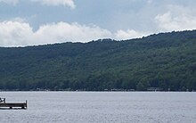
 View of Keuka Lake. | |
 Keuka Lake Location within New York | |
| Location | Steuben / Yates counties, New York, United States |
| Group | Finger Lakes |
| Coordinates | 42°29′47″N 77°08′46″W / 42.49639°N 77.14611°WCoordinates: 42°29′47″N 77°08′46″W / 42.49639°N 77.14611°W |
| Type | Ground moraine |
| Primary inflows | Keuka Inlet, Sugar Creek, Glen Brook, Wagener Glen Creek |
| Primary outflows | Keuka Lake Outlet |
| Basin countries | United States |
| Max. length | 20 mi (32 km) |
| Max. width | 0.5 to 2 mi (0.80 to 3.22 km) |
| Surface area | 11,730 acres (47.5 km2) |
| Average depth | 101 ft (31 m) |
| Max. depth | 187 ft (57 m) |
| Water volume | .35 sq mi (0.91 km2) |
| Shore length1 | 60 mi (97 km) |
| Surface elevation | 715 ft (218 m)[1] |
| Settlements | Penn Yan Hammondsport Branchport |
| 1 Shore length is not a well-defined measure. | |


Keuka Lake (/ˈkjuːkə/ KEW-kə)[2] is one of the major Finger Lakes in the U.S. state of New York. It is unusual because it is Y-shaped, in contrast to the long and narrow shape of the other Finger Lakes. Because of its shape, it was referred to in the past as Crooked Lake. Keuka means "canoe landing" in the Iroquois language and "lake with an elbow" in the Seneca language.[3]
Description[]
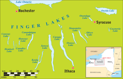
The Y-shaped Keuka Lake empties into another Finger Lake, Seneca Lake, through a stream called Keuka Lake Outlet at the lake's northeastern end in Penn Yan. The stream empties into Seneca Lake at the village of Dresden. At one time the outlet was developed into a canal, the Crooked Lake Canal, connecting the lakes. This canal was later replaced by a railroad branch line which is now a hiking and cycling trail, the Keuka Outlet Trail.
The lake is about 20 miles (32 km) long and varies in width from one-half mile (0.80 km) to two miles (3.2 km). It has a surface area of 11,730 acres (47.5 km2), and a maximum and mean depth of 186 feet (57 m) and 101 feet (31 m) respectively.
Its thermocline is between 30 and 35 feet (9.1 and 10.7 m) deep.[4]
Ecology[]
This body of water possesses large and healthy populations of lake trout, brown trout, rainbow trout, landlocked salmon, smallmouth bass, largemouth bass, and yellow perch. The productive fishery is supported by huge numbers of baitfish, most notably alewives (sawbellies), and is a very popular lake with area fishermen.
Humans, fish, and wildlife depend on the rich ecology of the lake habitat. The complex ecosystem is subject to contamination of the watershed, largely by storm water runoff. The Keuka Lake Association (KLA) monitors the water of the lake to ensure that it is suitable for its many uses, such as drinking, fishing, and swimming. Tributary streams, groundwater, and the lake itself are regularly tested for water quality. Additionally, KLA collects and publishes data about the lake level.
The infestation of European zebra mussels, which has impacted many North American bodies of water, has also affected Keuka Lake and other Finger Lakes in New York. In addition to disrupting the lake's ecosystem, zebra mussels can be a nuisance to lakeside homeowners. Their small size enables them to clog water intake pipes.[5][6] Furthermore, their sharp shells can cause lacerations on the feet of bathers. Bathers may wish to wear water shoes when swimming in the lake.
Surroundings[]

The village of Penn Yan is at the northeastern tip of the lake, and Branchport is at the northwestern tip. Hammondsport lies at the south end of the lake. Hammondsport was the home of Glenn Curtiss, a pioneer of naval aviation, and is now the site of the Glenn H. Curtiss Museum.
While the shore of the lake is primarily residential, Keuka College is located in Keuka Park on the western shore of the east branch and Keuka Lake State Park is located on the eastern side of the northwest branch of the lake. Camp Iroquois, run by the New York State Sheriffs Institute, is located on the eastern side of the bluff. YMCA Camp Cory is located on the eastern side of the northeast branch of the lake. Camp Good Days and Special Times is located on the western side of the northwest branch of the lake. Garrett Memorial Chapel is located near the tip of the bluff between the two branches.
An important component of the economy of this region is based on grape growing and wine production.[7]
Wine trail[]
These vineyards are included in the Keuka Lake Wine Trail:
- Barrington Cellars/Buzzard Crest Vineyards
- Bully Hill Vineyards
- Heron Hill Winery
- Hunt Country Vineyards
- Keuka Spring Vineyards
- Dr. Konstantin Frank's Vinifera Wine Cellars
- McGregor Vineyard Winery
- Ravines Wine Cellars
- Rooster Hill Winery
- Stever Hill Vineyards
- Point of the Bluff Vineyards
The winery on the lake, but not listed on the official Keuka Lake Wine Trail, is Domaine Leseurre.
See also[]
References[]
- ^ "Keuka Lake". Geographic Names Information System. United States Geological Survey. Retrieved June 9, 2015.
- ^ http://dictionary.reference.com/browse/keuka+lake
- ^ "Keuka Lake Tidbits". Archived from the original on 2011-07-26.
- ^ "Keuka Lake". Dec.ny.gov. NYS Department of Environmental Conservation. Retrieved December 1, 2015.
- ^ "Keuka Lake Book - Zebra Mussels". Archived from the original on 2013-04-15. Retrieved 2012-06-05.
- ^ Locations with Zebra Mussels
- ^ http://www.keukalake.com/
Further reading[]
- Beautiful Keuka Lake, from the Elmira Daily Advertiser, 1902
- Along the Outlet of Keuka Lake, by Frances Dumas
- An Excursion on the Keuka Maid, by Richard Sherer
- The Mary Bell: The Queen of Lake Keuka, from the Hammondsport Herald, 1892
- Keuka Cottage Boy, by Robert V. Anderson
External links[]
| Wikimedia Commons has media related to Keuka Lake. |
| Wikivoyage has a travel guide for Keuka Lake. |
- Keuka Lake Association
- NYS-DEC: Keuka Lake information
- Keuka Lake Outlet Trail
- New York State Parks: Keuka Lake State Park
- Finger Lakes
- Lakes of Yates County, New York
- Tourist attractions in Yates County, New York
- Lakes of Steuben County, New York
- Tourist attractions in Steuben County, New York
- Lakes of New York (state)