Canton of Attignat
Attignat | |
|---|---|
 | |
| Country | France |
| Region | Auvergne-Rhône-Alpes |
| Department | Ain |
| No. of communes | 18 |
| Seat | Attignat |
| Government | |
| • Representatives (2015-2021) | Clotilde Fournier Walter Martin |
| Area | 274.75 km2 (106.08 sq mi) |
| Population (Jan. 2018)[1] | 24,762 |
| • Density | 90/km2 (200/sq mi) |
| INSEE code | 01 02 |
The canton of Attignat is an administrative division of the Ain department, in eastern France. It was created at the French canton reorganisation which came into effect in March 2015. Its seat is in Attignat.[2]
Composition[]
It consists of the following communes:[2]
Councillors[]
| Election | Councillors | Party | Occupation | |
|---|---|---|---|---|
| 2015 | Clotilde Fournier | DVD | Mayor of Saint-Sulpice | |
| 2015 | Walter Martin | DVD | Mayor of Attignat | |
Pictures of the canton[]
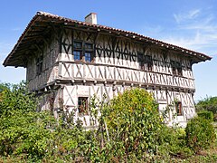 Manoir de la Charme in Montrevel-en-Bresse |
 Castle of Salvert in Attignat |

References[]

Categories:
- Cantons of Ain