Attignat
show This article may be expanded with text translated from the corresponding article in French. (June 2019) Click [show] for important translation instructions. |
Attignat | |
|---|---|
Commune | |
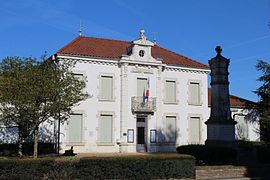 The town hall in Attignat | |
 Coat of arms | |
show Location of Attignat | |
 Attignat | |
| Coordinates: 46°17′17″N 5°09′38″E / 46.2881°N 5.1606°ECoordinates: 46°17′17″N 5°09′38″E / 46.2881°N 5.1606°E | |
| Country | France |
| Region | Auvergne-Rhône-Alpes |
| Department | Ain |
| Arrondissement | Bourg-en-Bresse |
| Canton | Attignat |
| Intercommunality | CA Bassin de Bourg-en-Bresse |
| Government | |
| • Mayor (2020–2026) | Walter Martin[1] |
| Area 1 | 18.69 km2 (7.22 sq mi) |
| Population (Jan. 2018)[2] | 3,196 |
| • Density | 170/km2 (440/sq mi) |
| Time zone | UTC+01:00 (CET) |
| • Summer (DST) | UTC+02:00 (CEST) |
| INSEE/Postal code | 01024 /01340 |
| Elevation | 199–233 m (653–764 ft) |
| 1 French Land Register data, which excludes lakes, ponds, glaciers > 1 km2 (0.386 sq mi or 247 acres) and river estuaries. | |


Attignat (French pronunciation: [atiɲa]; Arpitan: Ategnat) is a commune in the Ain department in eastern France. Since 2014, Walter Martin has been the mayor of Attignat. He was re-elected in the 2020 municipal elections.[3][1]
Geography[]
The commune is 12 km northwest of Bourg-en-Bresse, 4 km north of the A40. The Reyssouze runs through the commune.
Population[]
| Year | Pop. | ±% |
|---|---|---|
| 2006 | 2,487 | — |
| 2007 | 2,567 | +3.2% |
| 2008 | 2,662 | +3.7% |
| 2009 | 2,850 | +7.1% |
| 2010 | 2,936 | +3.0% |
| 2011 | 3,023 | +3.0% |
| 2012 | 3,110 | +2.9% |
| 2013 | 3,260 | +4.8% |
| 2014 | 3,386 | +3.9% |
| 2015 | 3,328 | −1.7% |
| 2016 | 3,270 | −1.7% |
See also[]
References[]
- ^ Jump up to: a b "Répertoire national des élus: les maires". data.gouv.fr, Plateforme ouverte des données publiques françaises (in French). 2 December 2020.
- ^ "Populations légales 2018". INSEE. 28 December 2020.
- ^ Ville d'Attignat, annuaire-mairie.fr
External links[]
| Wikimedia Commons has media related to Attignat. |
This Ain geographical article is a stub. You can help Wikipedia by . |
Categories:
- Communes of Ain
- Ain geography stubs