Capolago
Capolago | |
|---|---|
Village and Quarter | |
 Coat of arms | |
 | |
| Country | Switzerland |
| Canton | Ticino |
| District | Mendrisio |
| City | Mendrisio |
| Area | |
| • Total | 1.77 km2 (0.68 sq mi) |
| Population (2011-12-31)[1] | |
| • Total | 798 |
| • Density | 450/km2 (1,200/sq mi) |


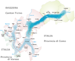
Capolago is a village situated at the south-eastern extremity of Lake Lugano, in the Swiss canton of Ticino. Originally a municipality in its own right, Capolago is now a quarter of the municipality of Mendrisio, itself part of the district of Mendrisio.[1][2]
History[]

The first mention of the name of Capolago appears before 1300, in the general statutes of Como. In 1365, Capolago assumed greater importance due to the building of castle. The castle was dismantled in 1517. From then on, the village was largely concerned with fishing, and the ferrying of people and goods to and from Lugano.[3][4]
In 1556, Capolago was the birthplace of the architect Carlo Maderno. He is best remembered as one of the fathers of Baroque architecture, responsible for the façades of St. Peter's Basilica, Santa Susanna, and Sant'Andrea della Valle, all in Rome.[3][4]
The construction of the Melide causeway, in 1841, followed by the opening of the local part of the Gotthard Railway, in 1874, saw changes to Capolago. The main road and railway brought better transport connections, but also reduced the need for boat services on the lake. However the opening of the Monte Generoso railway, in 1890, strengthened tourist traffic.[4]
In 1910, the Mendrisio electric tramway opened, linking a northern terminus in Riva San Vitale with Capolago, Mendrisio, Balerna and Chiasso. The section of the line in Capolago closed in 1948 and was replaced by a bus service.[5]
The town was also home to the historically important Tipografia Elvetica press, which published propaganda during the Italian Risorgimento. In 1891, the town hosted the Italian anarchist Capolago congress, attended by anarchists including Pietro Gori, Amilcare Cipriani, Francesco Saverio Merlino, and Errico Malatesta.[4]
In November 2007, the then independent municipalities of Arzo, Capolago, Genestrerio, Mendrisio, Rancate and Tremona voted to merge into the municipality of Mendrisio. The merger took place in April 2009.[6]
Transport[]
Capolago has a station, Capolago-Riva San Vitale, on the Gotthard line of the Swiss Federal Railways. The station is served by route S10 of the Treni Regionali Ticino Lombardia (TILO), which operate every half-hour between Bellinzona, Lugano and Chiasso, with some trains extending northwards to Airolo and southwards to Milan. The station is served also by the Monte Generoso railway, a mountain railway that climbs to the summit of the nearby Monte Generoso.[2][7]
Capolago also has a landing stage (Capolago Lago) that is served, once or twice a day, by the boats of the Società Navigazione del Lago di Lugano and by the trains of the Monte Generoso railway.[7][8]
Buses of the and AutoPostale serve stops outside the station, providing links to Arogno, Brusino Arsizio, Melano, Mendrisio, Porto Ceresio, Riva San Vitale and Rovio.[9]
References[]
- ^ Jump up to: a b c "Capolago" (in Italian). City of Mendresio. Archived from the original on 2012-07-17. Retrieved 2012-08-14.
- ^ Jump up to: a b map.geo.admin.ch (Map). Swiss Confederation. Retrieved 2012-08-14.
- ^ Jump up to: a b "Storia di Capolago" [History of Capolago] (in Italian). City of Mendresio. Archived from the original on 2011-05-25. Retrieved 2012-08-14.
- ^ Jump up to: a b c d "Capolago". Historical Dictionary of Switzerland (in Italian). Retrieved 2012-08-15.
- ^ "Tramvie Madrisiensi". www.eingestellte-bahnen.ch (in German). Archived from the original on 2012-01-05. Retrieved 2012-09-20.
- ^ Amtliches Gemeindeverzeichnis der Schweiz, Mutationsmeldungen 2009 / Répertoire officiel des communes de Suisse, Mutations 2009 / Elenco ufficiale dei Comuni della Svizzera, Mutazione 2009 (PDF) (Report). Federal Statistical Office. 2009. 2770. Archived from the original (PDF) on 2010-11-18. Retrieved 2010-03-06.
- ^ Jump up to: a b Eisenbahnatlas Schweiz. Verlag Schweers + Wall GmbH. 2012. p. 59. ISBN 978-3-89494-130-7.
- ^ "Timetable summer 2012". Società Navigazione del Lago di Lugano. Archived from the original on 2012-08-08. Retrieved 2012-08-01.
- ^ "Schema di rete - Trasporti pubblici" [Network diagram - Public transport] (in Italian). Canton of Ticino. Archived from the original on 2012-10-30. Retrieved 2012-09-19.
External links[]
 Media related to Capolago at Wikimedia Commons
- Capolago on the City of Mendrisio's web site
- Capolago in German, French and Italian in the online Historical Dictionary of Switzerland.
Coordinates: 45°54′10″N 8°58′46″E / 45.902817°N 8.979499°E

| show Authority control |
|---|
- Former municipalities of Ticino
- Villages in the Mendrisio District
- Populated places on Lake Lugano