Captain Arturo Prat Base
Prat Station | |
|---|---|
Antarctic base | |
| Arturo Prat Station | |
 Base Naval Antartica Arturo Prat | |
 Flag | |
 Prat Station Location of Prat Station in Antarctica | |
| Coordinates: 62°28′44″S 59°39′52″W / 62.478889°S 59.664444°WCoordinates: 62°28′44″S 59°39′52″W / 62.478889°S 59.664444°W | |
| Country | |
| Location in Antarctica | Iquique Cove Greenwich Island South Shetland Islands |
| Administered by | Chilean Navy |
| Established | 6 February 1947 |
| Named for | Arturo Prat |
| Population | |
| • Total |
|
| Type | All-year round |
| Period | Annual |
| Status | Operational |
| Website | Base Arturo Prat INACH |

Captain Arturo Prat Base is a Chilean Antarctic research station located at Iquique Cove, Greenwich Island in the South Shetland Islands, Antarctica.
Opened February 6, 1947 by the First Chilean Antarctic Expedition, it is the oldest Chilean Antarctic station. Until March 1, 2006, it was a base of the Chilean Navy, on which date it was handed over to the regional government of Magallanes and Antártica Chilena Region. Until February 2004, it had been a permanent base. Afterwards, it had served as a summer base for ionospheric and meteorologic research. There have been plans to reopen the station for permanent occupation starting March 2008. The base is named for Captain Arturo Prat, a Chilean naval officer.
Historic sites[]
- A concrete monolith was erected in 1947 near the base as a point of reference for Chilean Antarctic hydrographic surveys. It represents an important pre-IGY activity in Antarctica, and is preserved and maintained by personnel from the base. It has been designated a Historic Site or Monument (HSM 32), following a proposal by Chile to the Antarctic Treaty Consultative Meeting.[1]
- A shelter and cross with plaque was erected near the base and named after Lieutenant Commander González Pacheco, who died in 1960 while in charge of the station. It commemorates events related to a person whose role and the circumstances of his death have both symbolic and educational value relating to human activities in Antarctica. It has been designated a Historic Site or Monument (HSM 33), following a proposal by Chile to the Antarctic Treaty Consultative Meeting.[1]
- A bust of Chilean naval hero Arturo Prat was erected at the base in 1947. It represents pre-IGY activities and has symbolic value relating to Chilean presence in Antarctica. It has been designated a Historic Site or Monument (HSM 34), following a proposal by Chile to the Antarctic Treaty Consultative Meeting.[1]
- A wooden cross and statue of the Virgin of Carmel was erected in 1947 near the base. It represents pre-IGY activities and has both symbolic and architectural value. It has been designated a Historic Site or Monument (HSM 35), following a proposal by Chile to the Antarctic Treaty Consultative Meeting.[1]
Climate[]
The climate is maritime polar (Köppen: ET), being on the coast of the peninsula with less severe averages than expected in Antarctica.[2][3] Extreme temperatures can reach −29 °C or −20.2 °F in July, which is still quite bearable to humans protected due to considerable moderation of the sea, and a rare heat wave caused the temperature to reach 19 °C or 66.2 °F, a relatively high value. The climate is quite humid for its location and precipitation is fairly well distributed, so that even in the driest months it receives more precipitation than almost all of the Mediterranean zone.[4]
| Climate data for Captain Arturo Prat Base, elevation: 5 m or 16 ft, 1985-2011 seminormals | |||||||||||||
|---|---|---|---|---|---|---|---|---|---|---|---|---|---|
| Month | Jan | Feb | Mar | Apr | May | Jun | Jul | Aug | Sep | Oct | Nov | Dec | Year |
| Record high °C (°F) | 12.8 (55.0) |
19.3 (66.7) |
12.0 (53.6) |
8.0 (46.4) |
11.0 (51.8) |
9.0 (48.2) |
10.0 (50.0) |
8.0 (46.4) |
8.0 (46.4) |
7.5 (45.5) |
10.1 (50.2) |
14.4 (57.9) |
19.3 (66.7) |
| Average high °C (°F) | 3.6 (38.5) |
3.6 (38.5) |
2.5 (36.5) |
0.4 (32.7) |
−0.9 (30.4) |
−2.7 (27.1) |
−3.3 (26.1) |
−2.6 (27.3) |
−1.7 (28.9) |
−0.3 (31.5) |
0.9 (33.6) |
2.3 (36.1) |
0.1 (32.3) |
| Daily mean °C (°F) | 1.7 (35.1) |
1.8 (35.2) |
0.7 (33.3) |
−1.7 (28.9) |
−3.1 (26.4) |
−5.2 (22.6) |
−6.2 (20.8) |
−5.4 (22.3) |
−4.3 (24.3) |
−2.4 (27.7) |
−0.8 (30.6) |
0.5 (32.9) |
−2.0 (28.3) |
| Average low °C (°F) | 0.4 (32.7) |
0.4 (32.7) |
−1.0 (30.2) |
−3.6 (25.5) |
−5.3 (22.5) |
−7.9 (17.8) |
−9.2 (15.4) |
−8.4 (16.9) |
−7.0 (19.4) |
−4.4 (24.1) |
−2.3 (27.9) |
−0.8 (30.6) |
−4.1 (24.6) |
| Record low °C (°F) | −8.8 (16.2) |
−10.4 (13.3) |
−13.0 (8.6) |
−18.8 (−1.8) |
−24.0 (−11.2) |
−25.8 (−14.4) |
−29.2 (−20.6) |
−25.6 (−14.1) |
−22.0 (−7.6) |
−17.2 (1.0) |
−9.6 (14.7) |
−7.8 (18.0) |
−29.2 (−20.6) |
| Average precipitation mm (inches) | 63.8 (2.51) |
55.5 (2.19) |
70.3 (2.77) |
56.1 (2.21) |
48.4 (1.91) |
39.1 (1.54) |
38.6 (1.52) |
31.8 (1.25) |
43.2 (1.70) |
47.9 (1.89) |
69.7 (2.74) |
57.1 (2.25) |
621.5 (24.48) |
| Average precipitation days (≥ 1.0 mm) | 9.0 | 8.5 | 10.9 | 10.2 | 8.2 | 7.8 | 8.6 | 9.0 | 9.8 | 11.7 | 12.5 | 10.3 | 116.5 |
| Source: Climatebase.ru[5] | |||||||||||||
| Climate data for Captain Arturo Prat Base, elevation: 5 m or 16 ft, 1961-1990 normals, extremes 1958-present[a] | |||||||||||||
|---|---|---|---|---|---|---|---|---|---|---|---|---|---|
| Month | Jan | Feb | Mar | Apr | May | Jun | Jul | Aug | Sep | Oct | Nov | Dec | Year |
| Record high °C (°F) | 8.1 (46.6) |
8.8 (47.8) |
9.1 (48.4) |
5.0 (41.0) |
5.8 (42.4) |
4.2 (39.6) |
3.9 (39.0) |
3.2 (37.8) |
4.9 (40.8) |
4.9 (40.8) |
6.0 (42.8) |
9.7 (49.5) |
9.7 (49.5) |
| Mean maximum °C (°F) | 4.2 (39.6) |
5.1 (41.2) |
4.0 (39.2) |
2.5 (36.5) |
1.0 (33.8) |
0.7 (33.3) |
0.5 (32.9) |
0.0 (32.0) |
0.5 (32.9) |
1.3 (34.3) |
2.2 (36.0) |
3.3 (37.9) |
5.1 (41.2) |
| Daily mean °C (°F) | 1.2 (34.2) |
1.3 (34.3) |
0.2 (32.4) |
−2.0 (28.4) |
−4.0 (24.8) |
−5.7 (21.7) |
−6.7 (19.9) |
−6.7 (19.9) |
−4.6 (23.7) |
−2.8 (27.0) |
−1.0 (30.2) |
0.6 (33.1) |
−2.5 (27.5) |
| Mean minimum °C (°F) | −1.6 (29.1) |
−2.3 (27.9) |
−4.3 (24.3) |
−8.4 (16.9) |
−14.0 (6.8) |
−13.0 (8.6) |
−18.5 (−1.3) |
−19.0 (−2.2) |
−12.2 (10.0) |
−8.2 (17.2) |
−5.2 (22.6) |
−2.9 (26.8) |
−19.0 (−2.2) |
| Record low °C (°F) | −6.2 (20.8) |
−7.2 (19.0) |
−15.2 (4.6) |
−18.0 (−0.4) |
−24.8 (−12.6) |
−21.8 (−7.2) |
−30.0 (−22.0) |
−26.2 (−15.2) |
−26.0 (−14.8) |
−19.0 (−2.2) |
−12.2 (10.0) |
−7.0 (19.4) |
−30.0 (−22.0) |
| Average precipitation mm (inches) | 44.5 (1.75) |
70.8 (2.79) |
84.6 (3.33) |
53.5 (2.11) |
59.6 (2.35) |
52.4 (2.06) |
62.3 (2.45) |
61.6 (2.43) |
86.2 (3.39) |
77.3 (3.04) |
83.8 (3.30) |
61.3 (2.41) |
797.9 (31.41) |
| Average precipitation days (≥ 1.0 mm) | 10.0 | 12.0 | 15.0 | 10.0 | 8.0 | 10.0 | 7.0 | 10.0 | 12.0 | 12.0 | 15.0 | 11.0 | 132 |
| Average relative humidity (%) | 83 | 85 | 85 | 84 | 85 | 85 | 85 | 85 | 86 | 85 | 82 | 85 | 85 |
| Source 1: NOAA[6] | |||||||||||||
| Source 2: Dirección Meteorológica de Chile (extremes and averages extremes)[7][8] and DWD (precipitation days and humidity)[9] | |||||||||||||
Maps[]

- L.L. Ivanov et al. Antarctica: Livingston Island and Greenwich Island, South Shetland Islands. Scale 1:100,000 topographic map. Sofia: Antarctic Place-names Commission of Bulgaria, 2005.
- L.L. Ivanov. Antarctica: Livingston Island and Greenwich, Robert, Snow and Smith Islands. Scale 1:120,000 topographic map. Troyan: Manfred Wörner Foundation, 2010. ISBN 978-954-92032-9-5 (First edition 2009. ISBN 978-954-92032-6-4)
- Antarctic Digital Database (ADD). Scale 1:250000 topographic map of Antarctica. Scientific Committee on Antarctic Research (SCAR). Since 1993, regularly upgraded and updated.
Gallery[]

Location of Greenwich Island in the South Shetland Islands

View of base in 1957
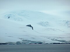
Arturo Prat Base from English Strait, with Rousseau Peak and Fuerza Aérea Glacier in the background


See also[]
- List of Antarctic research stations
- List of Antarctic field camps
Notes[]
- ^ Although there are several gaps (periods without data) that compromise the historical series. Days of precipitation are only 1983-1990 and relative humidity from 1968-1990.
References[]
- ^ a b c d "List of Historic Sites and Monuments approved by the ATCM (2012)" (PDF). Antarctic Treaty Secretariat. 2012. Retrieved 2013-12-30.
- ^ "World Maps of Köppen-Geiger climate classification". koeppen-geiger.vu-wien.ac.at. Retrieved 2019-07-22.
- ^ "What happens to Steig et al's warming when you divide Antarctica into two distinct climate zones?". Watts Up With That?. 2009-04-18. Retrieved 2019-07-22.
- ^ "Base Arturo Prat Climate History". Weather2. Retrieved July 22, 2019.
- ^ "Capitan Arturo Prat, Antarctica #89057". Climatebase.ru. Retrieved July 22, 2019.
- ^ "Captain Arturo Prat Base (89057) - WMO Weather Station". NOAA. Retrieved July 22, 2019.
- ^ "Temperatura Histórica Anual de la Estación - Arturo Prat, Base Antártica (950002)". Dirección Meteorológica de Chile. Retrieved July 22, 2019.
- ^ "Temperatura Histórica de la Estación- Arturo Prat, Base Antártica (950002)". Dirección Meteorológica de Chile. Retrieved July 22, 2019.
- ^ "Klimatafel n Basis "Arturo Prat" (Chile) / Antarktis" (PDF). Baseline climate means (1961–1990) from stations all over the world (in German). Deutscher Wetterdienst. Retrieved July 22, 2019.
External links[]
| Wikimedia Commons has media related to Captain Arturo Prat Base. |
- Official website Chilean antarctic Institute
- Official website Chilean Navy
- COMNAP Antarctic Facilities
- COMNAP Antarctic Facilities Map
- Map of Greenwich and Livingston Islands
Antarctica | ||
|---|---|---|
| General |
|  |
| Regions |
| |
| Waterways |
| |
| Famous explorers |
| |
- Outposts of Antarctica
- Buildings and structures completed in 1947
- Chilean Antarctic Territory
- Geography of Greenwich Island
- Historic Sites and Monuments of Antarctica
- Outposts of the South Shetland Islands
- 1947 establishments in Antarctica