Caraghnan, New South Wales
Caraghnan Parish, New South Wales is a bounded rural locality in Coonamble Shire and a civil parish of Gowen County, New South Wales.[1][2]
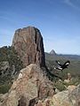
The parish located at 31°17′54″S 149°01′04″ is in the Warrumbungle National Park.[3]
, New South Wales

Warrumbungle breadknife
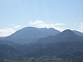
Siding Spring from


References[]
- ^ Robert McLean, The New atlas of Australia : the complete work containing over one hundred maps and full descriptive geography of New South Wales, Victoria, Queensland, South Australia and Western Australia, together with numerous illustrations and copious indices (Sydney :J. Sands, [1886) Map 1.
- ^ Map of Gowan County, New South Wales.
- ^ Robert McLean, The New atlas of Australia : the complete work containing over one hundred maps and full descriptive geography of New South Wales, Victoria, Queensland, South Australia and Western Australia, together with numerous illustrations and copious indices (Sydney :J. Sands, [1886) Map 14.
This Central West geography article is a stub. You can help Wikipedia by . |
Categories:
- Localities in New South Wales
- Geography of New South Wales
- Central West (New South Wales)
- Central West, New South Wales geography stubs