Carrollton Township, Carroll County, Indiana
Carrollton Township | |
|---|---|
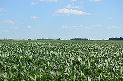 Cornfield southeast of Sharon | |
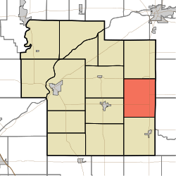 Location of Carrollton Township in Carroll County | |
| Coordinates: 40°33′36″N 86°25′12″W / 40.56000°N 86.42000°WCoordinates: 40°33′36″N 86°25′12″W / 40.56000°N 86.42000°W | |
| Country | United States |
| State | Indiana |
| County | Carroll |
| Government | |
| • Type | Indiana township |
| Area | |
| • Total | 29.59 sq mi (76.6 km2) |
| • Land | 29.58 sq mi (76.6 km2) |
| • Water | 0.01 sq mi (0.03 km2) |
| Elevation | 725 ft (221 m) |
| Population (2010) | |
| • Total | 598 |
| • Density | 20.2/sq mi (7.8/km2) |
| FIPS code | 18-10540[2] |
| GNIS feature ID | 453160 |

Carrollton Township is one of fourteen townships in Carroll County, Indiana. As of the 2010 census, its population was 598 and it contained 244 housing units.[3]
History[]
Carrollton Township was organized in 1835.[4]
Geography[]
According to the 2010 census, the township has a total area of 29.59 square miles (76.6 km2), of which 29.58 square miles (76.6 km2) (or 99.97%) is land and 0.01 square miles (0.026 km2) (or 0.03%) is water.[3]
Unincorporated towns[]
Adjacent townships[]
- Washington Township (north)
- Deer Creek Township, Cass County (northeast)
- Ervin Township, Howard County (east)
- Burlington Township (south)
- Jackson Township (west)
- Monroe Township (west)
Major highways[]
References[]
- "Carrollton Township, Carroll County, Indiana". Geographic Names Information System. United States Geological Survey. Retrieved 2009-09-24.
- United States Census Bureau cartographic boundary files
- ^ "US Board on Geographic Names". United States Geological Survey. 2007-10-25. Retrieved 2008-01-31.
- ^ "U.S. Census website". United States Census Bureau. Retrieved 2008-01-31.
- ^ a b "Population, Housing Units, Area, and Density: 2010 - County -- County Subdivision and Place -- 2010 Census Summary File 1". United States Census. Archived from the original on 2020-02-12. Retrieved 2013-05-10.
- ^ Odell, John Curtis (1916). History of Carroll County, Indiana: Its People, Industries and Institutions. B.F. Bowen. p. 81.
External links[]
| Wikimedia Commons has media related to Carrollton Township, Carroll County, Indiana. |
Municipalities and communities of Carroll County, Indiana, United States | ||
|---|---|---|
| City | ||
| Towns | ||
| Townships | ||
| CDPs | ||
| Other communities | ||
| ||
Categories:
- Townships in Carroll County, Indiana