Castel Vittorio
Castelvittorio | |
|---|---|
| Comune di Castelvittorio | |
 | |
 Coat of arms | |
show Location of Castelvittorio | |
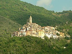
 Castelvittorio Location of Castelvittorio in Italy | |
| Coordinates: 43°55′N 7°40′E / 43.917°N 7.667°E | |
| Country | Italy |
| Region | Liguria |
| Province | Imperia (IM) |
| Government | |
| • Mayor | Gian Stefano Orengo |
| Area | |
| • Total | 25.8 km2 (10.0 sq mi) |
| Elevation | 420 m (1,380 ft) |
| Population | |
| • Total | 355 |
| • Density | 14/km2 (36/sq mi) |
| Demonym(s) | Castellesi |
| Time zone | UTC+1 (CET) |
| • Summer (DST) | UTC+2 (CEST) |
| Postal code | 18037 |
| Dialing code | 0184 |
| Patron saint | St. Stephen |
| Saint day | 26 December |
| Website | Official website |


Castelvittorio (Ligurian: Caste, locally U Casté) is a comune (municipality) in the Province of Imperia in the Italian region Liguria, located about 120 kilometres (75 mi) southwest of Genoa and about 30 kilometres (19 mi) west of Imperia.
Castelvittorio borders the following municipalities: Apricale, Bajardo, Isolabona, Molini di Triora, Pigna and Triora.
The parish church of St. Stephen houses 16th or 17th century bas-relief, a Crucifixion of Jesus by Marcello Venusti (late 16th century) and a crucifix by Anton Maria Maragliano.
References[]
- ^ "Superficie di Comuni Province e Regioni italiane al 9 ottobre 2011". Istat. Retrieved 16 March 2019.
- ^ "Popolazione Residente al 1° Gennaio 2018". Istat. Retrieved 16 March 2019.
- ^ All demographics and other statistics: Italian statistical institute Istat.
| Authority control |
|---|
This Liguria location article is a stub. You can help Wikipedia by . |
Categories:
- Cities and towns in Liguria
- Municipalities of the Province of Imperia
- Liguria geography stubs