Cathedral Rock (Coconino County, Arizona)
| Cathedral Rock | |
|---|---|
 Southeast aspect | |
| Highest point | |
| Elevation | 3,942 ft (1,202 m)[1] |
| Prominence | 342 ft (104 m)[1] |
| Parent peak | Paria Plateau[2] |
| Isolation | 2.61 mi (4.20 km)[2] |
| Coordinates | 36°49′42″N 111°38′23″W / 36.8283207°N 111.6396060°WCoordinates: 36°49′42″N 111°38′23″W / 36.8283207°N 111.6396060°W[3] |
| Geography | |
 Cathedral Rock Location in Arizona | |
| Location | Glen Canyon National Recreation Area Coconino County, Arizona, U.S. |
| Parent range | Colorado Plateau |
| Topo map | USGS Navajo Bridge |
| Geology | |
| Age of rock | Triassic |
| Type of rock | Sandstone |
| Climbing | |
| Easiest route | class 3+ scrambling[2] |


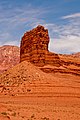
Cathedral Rock is a 3,942-foot-elevation (1,202 m) pillar located within Glen Canyon National Recreation Area, in Coconino County of northern Arizona.[3] It is situated less than one mile northwest of Navajo Bridge, and three miles (4.8 km) southwest of Lee's Ferry and the confluence of the Paria and Colorado Rivers, where it towers over 400 feet (120 m) above the surrounding terrain as a landmark of the area. It can be seen from nearby U.S. Route 89A (US 89A) at Marble Canyon. This geographical feature's name was bestowed prior to 1900, and officially adopted in 1969 by the U.S. Board on Geographic Names.[3]
Geology[]
Cathedral Rock is located on the Colorado Plateau. This erosional remnant is composed of red sandstone of the Moenkopi Formation, which was laid down during the Triassic. It is overlain by a Shinarump Conglomerate caprock.[4] Precipitation runoff from this feature drains to the nearby Colorado River, one-half mile to the east.
Gallery[]

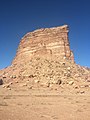
South face

Cathedral Rock, with Vermilion Cliffs behind


Cathedral Rock left of center (illuminated) above Navajo Bridge, Vermilion Cliffs National Monument further in the distance.


Climate[]
According to the Köppen climate classification system, Cathedral Rock is located in an arid climate zone with hot, very dry summers, and chilly winters with very little snow. Climate data for Page, Arizona, 12 miles to the northeast.
| Climate data for Page, Arizona | |||||||||||||
|---|---|---|---|---|---|---|---|---|---|---|---|---|---|
| Month | Jan | Feb | Mar | Apr | May | Jun | Jul | Aug | Sep | Oct | Nov | Dec | Year |
| Record high °F (°C) | 64 (18) |
72 (22) |
82 (28) |
91 (33) |
102 (39) |
107 (42) |
109 (43) |
106 (41) |
100 (38) |
93 (34) |
77 (25) |
66 (19) |
109 (43) |
| Average high °F (°C) | 43.1 (6.2) |
50.3 (10.2) |
59.5 (15.3) |
68.5 (20.3) |
78.5 (25.8) |
90.2 (32.3) |
95.1 (35.1) |
92.0 (33.3) |
83.5 (28.6) |
69.7 (20.9) |
53.8 (12.1) |
43.7 (6.5) |
69.0 (20.6) |
| Average low °F (°C) | 26.3 (−3.2) |
30.4 (−0.9) |
37.0 (2.8) |
43.6 (6.4) |
52.6 (11.4) |
62.3 (16.8) |
68.3 (20.2) |
66.4 (19.1) |
58.4 (14.7) |
46.6 (8.1) |
34.7 (1.5) |
27.1 (−2.7) |
46.1 (7.8) |
| Record low °F (°C) | −11 (−24) |
6 (−14) |
18 (−8) |
25 (−4) |
31 (−1) |
44 (7) |
56 (13) |
46 (8) |
40 (4) |
24 (−4) |
16 (−9) |
1 (−17) |
−11 (−24) |
| Average precipitation inches (mm) | 0.61 (15) |
0.48 (12) |
0.65 (17) |
0.50 (13) |
0.40 (10) |
0.14 (3.6) |
0.58 (15) |
0.69 (18) |
0.66 (17) |
0.99 (25) |
0.56 (14) |
0.48 (12) |
6.74 (171.6) |
| Average snowfall inches (cm) | 2.1 (5.3) |
1.2 (3.0) |
0.2 (0.51) |
0 (0) |
0 (0) |
0 (0) |
0 (0) |
0 (0) |
0 (0) |
0 (0) |
0.5 (1.3) |
1.4 (3.6) |
5.4 (13.71) |
| Average precipitation days (≥ 0.01 in) | 4.5 | 4.0 | 5.2 | 3.5 | 3.2 | 1.7 | 4.6 | 5.2 | 4.5 | 4.3 | 3.2 | 3.9 | 47.8 |
| Average snowy days (≥ 0.1 in) | 0.9 | 0.6 | 0.3 | 0 | 0 | 0 | 0 | 0 | 0 | 0 | 0.2 | 0.6 | 2.6 |
| Source: NOAA[5] | |||||||||||||
See also[]
References[]
- ^ a b "Cathedral Rock, Arizona". Peakbagger.com. Retrieved 2020-12-10.[self-published source?]
- ^ a b c "Cathedral Rock - 3,942' AZ". Lists of John. Retrieved December 10, 2020.
- ^ a b c "Cathedral Rock". Geographic Names Information System. United States Geological Survey. Retrieved December 10, 2020.
- ^ David A. Phoenix, Geology of the Lees Ferry Area Coconino County, Arizona Geological Survey Bulletin 1137, 1963, US Government Printing Office.
- ^ "Climatography of the United States No. 20 (1971–2000)" (PDF). National Oceanic and Atmospheric Administration. 2004. Retrieved 2010-05-31.[permanent dead link]
External links[]
- Weather forecast: National Weather Service
- Colorado Plateau
- Landforms of Coconino County, Arizona
- Sandstone formations of the United States
- Glen Canyon National Recreation Area
- Buttes of Arizona