Arizona
Arizona | |
|---|---|
State | |
| State of Arizona | |
| Nickname(s): The Grand Canyon State; The Copper State; The Valentine State | |
| Motto(s): Ditat Deus (God enriches) | |
| Anthem: "The Arizona March Song" and "Arizona" | |
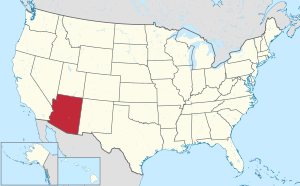 Map of the United States with Arizona highlighted | |
| Country | United States |
| Before statehood | Arizona Territory |
| Admitted to the Union | February 14, 1912 (48th) |
| Capital (and largest city) | Phoenix |
| Largest metro and urban areas | Greater Phoenix |
| Government | |
| • Governor | Doug Ducey (R) |
| • Secretary of State | Katie Hobbs (D) |
| Legislature | Arizona Legislature |
| • Upper house | Senate |
| • Lower house | House of Representatives |
| Judiciary | Arizona Supreme Court |
| U.S. senators | Kyrsten Sinema (D) Mark Kelly (D) |
| U.S. House delegation | 5 Democrats 4 Republicans (list) |
| Area | |
| • Total | 113,990[1] sq mi (295,234 km2) |
| Area rank | 6th |
| Dimensions | |
| • Length | 400 mi (645 km) |
| • Width | 310 mi (500 km) |
| Elevation | 4,100 ft (1,250 m) |
| Highest elevation | 12,637 ft (3,852 m) |
| Lowest elevation | 72 ft (22 m) |
| Population (2020) | |
| • Total | 7,151,502[5] |
| • Rank | 14th |
| • Density | 57/sq mi (22/km2) |
| • Density rank | 33rd |
| • Median household income | $56,581[6] |
| • Income rank | 29th |
| Demonym(s) | Arizonan[7] |
| Language | |
| • Official language | English |
| • Spoken language | As of 2010
|
| Time zones | |
| Most of state | UTC−07:00 (Mountain) |
| Navajo Nation | UTC−07:00 (Mountain) |
| • Summer (DST) | UTC−06:00 (MDT) |
| USPS abbreviation | AZ |
| ISO 3166 code | US-AZ |
| Traditional abbreviation | Ariz. |
| Latitude | 31°20′ N to 37° N |
| Longitude | 109°03′ W to 114°49′ W |
| Website | az |
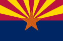

| hideArizona state symbols | |
|---|---|
 | |
 | |
| Living insignia | |
| Amphibian | Arizona tree frog |
| Bird | Cactus wren |
| Butterfly | Two-tailed swallowtail |
| Fish | Apache trout |
| Flower | Saguaro cactus blossom |
| Mammal | Ring-tailed cat |
| Reptile | Arizona ridge-nosed rattlesnake |
| Tree | Palo verde |
| Inanimate insignia | |
| Colors | Blue, old gold |
| Firearm | Colt Single Action Army revolver |
| Fossil | Petrified wood |
| Gemstone | Turquoise |
| Mineral | Fire agate |
| Rock | Petrified wood |
| Ship | USS Arizona |
| Slogan | The Grand Canyon State |
| Soil | Casa Grande |
| State route marker | |
 | |
| State quarter | |
 Released in 2008 | |
| Lists of United States state symbols | |


Arizona (/ˌɛərɪˈzoʊnə/ (![]() listen) AIR-iz-OH-nə; Navajo: Hoozdo Hahoodzo Navajo pronunciation: [hoː˥z̥to˩ ha˩hoː˩tso˩];[8] O'odham: Alĭ ṣonak)[9] is a state in the Western United States, grouped in the Southwestern and occasionally Mountain subregions. It is the 6th largest and the 14th most populous of the 50 states. Its capital and largest city is Phoenix. Arizona shares the Four Corners region with Utah to the north, Colorado to the northeast, and New Mexico to the east; its other neighboring states are Nevada and California to the west and the Mexican states of Sonora and Baja California to the south and southwest.
listen) AIR-iz-OH-nə; Navajo: Hoozdo Hahoodzo Navajo pronunciation: [hoː˥z̥to˩ ha˩hoː˩tso˩];[8] O'odham: Alĭ ṣonak)[9] is a state in the Western United States, grouped in the Southwestern and occasionally Mountain subregions. It is the 6th largest and the 14th most populous of the 50 states. Its capital and largest city is Phoenix. Arizona shares the Four Corners region with Utah to the north, Colorado to the northeast, and New Mexico to the east; its other neighboring states are Nevada and California to the west and the Mexican states of Sonora and Baja California to the south and southwest.
Arizona is the 48th state and last of the contiguous states to be admitted to the Union, achieving statehood on February 14, 1912. Historically part of the territory of Alta California in New Spain, it became part of independent Mexico in 1821. After being defeated in the Mexican–American War, Mexico ceded much of this territory to the United States in 1848. The southernmost portion of the state was acquired in 1853 through the Gadsden Purchase.
Southern Arizona is known for its desert climate, with very hot summers and mild winters. Northern Arizona features forests of pine, Douglas fir, and spruce trees; the Colorado Plateau; mountain ranges (such as the San Francisco Mountains); as well as large, deep canyons, with much more moderate summer temperatures and significant winter snowfalls. There are ski resorts in the areas of Flagstaff, Alpine, and Tucson. In addition to the internationally known Grand Canyon National Park, which is one of the world's seven natural wonders, there are several national forests, national parks, and national monuments.
Since the 1950s, Arizona's population and economy have grown dramatically because of migration into the state, and now the state is a major hub of the Sun Belt. Cities such as Phoenix and Tucson have developed large, sprawling suburban areas. Many large companies, such as PetSmart and Circle K,[10] have headquarters in the state, and Arizona is home to major universities, including the University of Arizona and Arizona State University. Traditionally, the state is politically known for national conservative figures such as Barry Goldwater and John McCain, though it voted Democratic in the 1996 presidential race and in the 2020 presidential and senatorial elections.
Arizona is home to a diverse population. About one-quarter of the state[11][better source needed] is made up of Indian reservations that serve as the home of 27 federally recognized Native American tribes, including the Navajo Nation, the largest in the state and the United States, with more than 300,000 citizens. Since the 1980s, the proportion of Hispanics in the state's population has grown significantly owing to migration from Mexico. The state also has a substantial Catholic and Mormon population.
Etymology[]
The state's name appears to originate from an earlier Spanish name, Arizonac, derived from the O'odham name alĭ ṣonak, meaning "small spring", which initially applied only to an area near the silver mining camp of Planchas de Plata, Sonora.[12][13][14][15] To the European settlers, their pronunciation sounded like Arissona.[16] The area is still known as alĭ ṣonak in the O'odham language.[9] Another possible origin is the Basque phrase haritz ona ("the good oak"), as there were numerous Basque sheepherders in the area.[17][18][19] A native Mexican of Basque heritage established the ranchería (village) of Arizona between 1734 and 1736 in the current Mexican state of Sonora, which became notable after a significant discovery of silver there, c. 1737.[20]
The misconception that the state's name originated from the supposedly Spanish term Árida Zona ("Arid Zone") is considered a case of folk etymology.[16]
History[]
This section needs additional citations for verification. (February 2018) |


For thousands of years before the modern era, Arizona was home to many ancient Native American civilizations. Hohokam, Mogollon, and Ancestral Puebloan cultures were among those that flourished throughout the state. Many of their pueblos, cliffside dwellings, rock paintings and other prehistoric treasures have survived and attract thousands of tourists each year.

In 1539, Marcos de Niza, a Spanish Franciscan, became the first European to contact Native Americans. He explored parts of the present state and made contact with native inhabitants, probably the Sobaipuri. The expedition of Spanish explorer Coronado entered the area in 1540–1542 during its search for Cíbola. Few Spanish settlers migrated to Arizona. One of the first settlers in Arizona was José Romo de Vivar.[21]
Father Kino was the next European in the region. A member of the Society of Jesus ("Jesuits"), he led the development of a chain of missions in the region. He converted many of the Indians to Christianity in the Pimería Alta (now southern Arizona and northern Sonora) in the 1690s and early 18th century. Spain founded presidios ("fortified towns") at Tubac in 1752 and Tucson in 1775.
When Mexico achieved its independence from the Kingdom of Spain and its Spanish Empire in 1821, what is now Arizona became part of its Territory of Nueva California, ("New California"), also known as Alta California ("Upper California").[22] Descendants of ethnic Spanish and mestizo settlers from the colonial years still lived in the area at the time of the arrival of later European-American migrants from the United States.

During the Mexican–American War (1847–1848), the U.S. Army occupied the national capital of Mexico City and pursued its claim to much of northern Mexico, including what later became Arizona Territory in 1863 and later the State of Arizona in 1912. The Treaty of Guadalupe Hidalgo (1848) specified that, in addition to language and cultural rights of the existing inhabitants of former Mexican citizens being considered as inviolable, the sum of $15 million in compensation (equivalent to $448,673,076.92 in 2020) be paid to the Republic of Mexico.[23] In 1853, the U.S. acquired the land south below the Gila River from Mexico in the Gadsden Purchase along the southern border area as encompassing the best future southern route for a transcontinental railway.
What is now known as the state of Arizona was initially administered by the United States government as part of the Territory of New Mexico until the southern part of that region seceded from the Union to form the Territory of Arizona.[24] This newly established territory was formally organized by the federal government of the Confederate States on Saturday, January 18, 1862, when President Jefferson Davis approved and signed An Act to Organize the Territory of Arizona,[25] marking the first official use of the name "Territory of Arizona". The Southern territory supplied the Confederate government with men, horses, and equipment. Formed in 1862, Arizona scout companies served with the Confederate States Army during the American Civil War. Arizona has the westernmost military engagement on record during the Civil War with the Battle of Picacho Pass (1862).

The Federal government declared a new U.S. Arizona Territory, consisting of the western half of earlier New Mexico Territory, in Washington, D.C., on February 24, 1863. These new boundaries would later form the basis of the state. The first territorial capital, Prescott, was founded in 1864 following a gold rush to central Arizona.[26] The capital was later moved to Tucson, back to Prescott, and then to its final location in Phoenix in a series of controversial moves as different regions of the territory gained and lost political influence with the growth and development of the territory.[27]
Although names including "Gadsonia", "Pimeria", "Montezuma" and "Arizuma" had been considered for the territory,[28] when 16th President Abraham Lincoln signed the final bill, it read "Arizona", and that name was adopted. (Montezuma was not derived from the Aztec emperor, but was the sacred name of a divine hero to the Pima people of the Gila River Valley. It was probably considered—and rejected—for its sentimental value before Congress settled on the name "Arizona".)
Brigham Young, patriarchal leader of The Church of Jesus Christ of Latter-day Saints in Salt Lake City in Utah, sent Mormons to Arizona in the mid- to late 19th century. They founded Mesa, Snowflake, Heber, Safford, and other towns. They also settled in the Phoenix Valley (or "Valley of the Sun"), Tempe, Prescott, and other areas. The Mormons settled what became northern Arizona and northern New Mexico. At the time these areas were in a part of the former New Mexico Territory.
During the nineteenth century, a series of gold and silver rushes occurred in the territory, the best known being the 1870s stampede to the silver bonanzas of Tombstone, Arizona in southeast Arizona, also known for its legendary outlaws and lawmen.[29] By the late 1880s, copper production eclipsed the precious metals with the rise of copper camps like Bisbee, Arizona and Jerome, Arizona.[30][31] The boom and bust economy of mining also left hundreds of ghost towns across the territory, but copper mining continued to prosper with the territory producing more copper than any other state by 1907, which earned Arizona the nickname "the Copper State" at the time of statehood.[32][33] During the first years of statehood the industry experienced growing pains and labor disputes with the Bisbee Deportation of 1917 the result of a copper miners' strike.[34] The state continues to produce half of the nation's newly mined copper.

20th century to present[]
During the Mexican Revolution from 1910 to 1920, several battles were fought in the Mexican towns just across the border from Arizona settlements. Throughout the revolution, many Arizonans enlisted in one of the several armies fighting in Mexico. Only two significant engagements took place on U.S. soil between U.S. and Mexican forces: Pancho Villa's 1916 Columbus Raid in New Mexico, and the Battle of Ambos Nogales in 1918 in Arizona. The Mexicans won the first battle and the Americans won the latter.
After Mexican federal troops fired on U.S. soldiers, the American garrison launched an assault into Nogales, Mexico. The Mexicans eventually surrendered after both sides sustained heavy casualties. A few months earlier, just west of Nogales, an Indian War battle had occurred, considered the last engagement in the American Indian Wars, which lasted from 1775 to 1918. U.S. soldiers stationed on the border confronted Yaqui Indians who were using Arizona as a base to raid the nearby Mexican settlements, as part of their wars against Mexico.
Arizona became a U.S. state on February 14, 1912. Arizona was the 48th state admitted to the U.S. and the last of the contiguous states to be admitted.

Cotton farming and copper mining, two of Arizona's most important statewide industries, suffered heavily during the Great Depression. But during the 1920s and even the 1930s, tourism began to develop as the important Arizonan industry it is today. Dude ranches, such as the K L Bar and Remuda in Wickenburg, along with the Flying V and Tanque Verde in Tucson, gave tourists the chance to take part in the flavor and activities of the "Old West". Several upscale hotels and resorts opened during this period, some of which are still top tourist draws. They include the Arizona Biltmore Hotel in central Phoenix (opened 1929) and the Wigwam Resort on the west side of the Phoenix area (opened 1936).
Arizona was the site of German prisoner of war camps during World War II and Japanese American internment camps. Because of wartime fears of a Japanese invasion of the U.S. West Coast (which in fact materialized in the Aleutian Islands Campaign in June 1942), the government authorized the removal of all Japanese American residents from all the Alaska Territory and California, the western halves of Washington and Oregon, and Southern Arizona. From 1942 to 1945, they were forced to reside in internment camps built in the interior of the country. Many lost their homes and businesses. The camps were abolished after World War II.
The Phoenix-area German P.O.W. site was purchased after the war by the Maytag family (of major home appliance fame). It was developed as the site of the Phoenix Zoo. A Japanese-American internment camp was on Mount Lemmon, just outside the state's southeastern city of Tucson. Another POW camp was near the Gila River in eastern Yuma County.
Arizona was also home to the Phoenix Indian School, one of several federal Indian boarding schools designed to assimilate Native American children into mainstream European-American culture. Children were often enrolled in these schools against the wishes of their parents and families. Attempts to suppress native identities included forcing the children to cut their hair, to take and use English names, to speak only English, and to practice Christianity rather than their native religions.[35]
Numerous Native Americans from Arizona fought for the United States during World War II. Their experiences resulted in a rising activism in the postwar years to achieve better treatment and civil rights after their return to the state. After Maricopa County did not allow them to register to vote, in 1948 veteran Frank Harrison and Harry Austin, of the at Fort McDowell Indian Reservation, brought a legal suit, Harrison and Austin v. Laveen, to challenge this exclusion. The Arizona Supreme Court ruled in their favor.[36]
Arizona's population grew tremendously with residential and business development after World War II, aided by the widespread use of air conditioning, which made the intensely hot summers more comfortable. According to the Arizona Blue Book (published by the Arizona Secretary of State's office each year), the state population in 1910 was 294,353. By 1970, it was 1,752,122. The percentage growth each decade averaged about 20% in the earlier decades, and about 60% each decade thereafter.
In the 1960s, retirement communities were developed. These age-restricted subdivisions catered exclusively to the needs of senior citizens and attracted many retirees who wanted to escape the harsh winters of the Midwest and the Northeast. Sun City, established by developer Del Webb and opened in 1960, was one of the first such communities. Green Valley, south of Tucson, was another such community, designed as a retirement subdivision for Arizona's teachers. Many senior citizens from across the U.S. and Canada come to Arizona each winter and stay only during the winter months; they are referred to as snowbirds.
In March 2000, Arizona was the site of the first legally binding election ever held over the internet to nominate a candidate for public office.[37] In the 2000 Arizona Democratic Primary, under worldwide attention, Al Gore defeated Bill Bradley. Voter turnout in this state primary increased more than 500% over the 1996 primary.
In the 21st century, Arizona has frequently garnered national attention for its efforts to quell illegal immigration into the state. In 2004, voters passed Proposition 200, requiring proof of citizenship to register to vote. The Supreme Court of the United States struck this restriction down in 2013.[38] In 2010, Arizona enacted SB 1070 which required all immigrants to carry immigration papers at all times, but the Supreme Court also invalidated parts of this law in Arizona v. United States in 2012.
On January 8, 2011, a gunman shot congresswoman Gabby Giffords and 18 others at a gathering in Tucson. Giffords was critically wounded. The incident sparked national attention regarding incendiary political rhetoric.[39]
Three ships named USS Arizona have been christened in honor of the state, although only USS Arizona (BB-39) was so named after statehood was achieved.
Geography[]


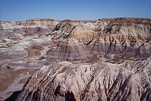
Arizona is in the Southwestern United States as one of the Four Corners states. Arizona is the sixth largest state by area, ranked after New Mexico and before Nevada. Of the state's 113,998 square miles (295,000 km2), approximately 15% is privately owned. The remaining area is public forest and park land, state trust land and Native American reservations. There are 24 National Park Service maintained sites in Arizona, including the three national parks of Grand Canyon National Park, Saguaro National Park, and the Petrified Forest National Park.[40]
Arizona is well known for its desert Basin and Range region in the state's southern portions, which is rich in a landscape of xerophyte plants such as the cactus. This region's topography was shaped by prehistoric volcanism, followed by the cooling-off and related subsidence. Its climate has exceptionally hot summers and mild winters. The state is less well known for its pine-covered north-central portion of the high country of the Colorado Plateau (see Arizona Mountains forests).
Like other states of the Southwest United States, Arizona is marked by high mountains, the Colorado plateau, and mesas. Despite the state's aridity, 27% of Arizona is forest,[41] a percentage comparable to modern-day Romania or Greece.[42] The world's largest stand of ponderosa pine trees is in Arizona.[43]
The Mogollon Rim (/ ˌmoʊ gəˈyoʊn /), a 1,998-foot (609 m) escarpment, cuts across the state's central section and marks the southwestern edge of the Colorado Plateau. In 2002, this was an area of the Rodeo–Chediski Fire, the worst fire in state history until 2011.
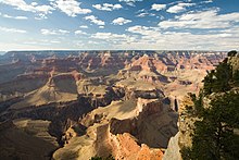
Located in northern Arizona, the Grand Canyon is a colorful, deep, steep-sided gorge, carved by the Colorado River. The canyon is one of the Seven Natural Wonders of the World and is largely contained in the Grand Canyon National Park—one of the first national parks in the United States. President Theodore Roosevelt was a major proponent of designating the Grand Canyon area as a National Park, often visiting to hunt mountain lion and enjoy the scenery. The canyon was created by the Colorado River cutting a channel over millions of years, and is about 277 miles (446 km) long, ranges in width from 4 to 18 miles (6 to 29 km) and attains a depth of more than 1 mile (1.6 km). Nearly two billion years of the Earth's history have been exposed as the Colorado River and its tributaries cut through layer after layer of sediment as the Colorado Plateau uplifted.
Arizona is home to one of the most well-preserved meteorite impact sites in the world. Created around 50,000 years ago, the Barringer Meteorite Crater (better known simply as "Meteor Crater") is a gigantic hole in the middle of the high plains of the Colorado Plateau, about 25 miles (40 km) west of Winslow. A rim of smashed and jumbled boulders, some of them the size of small houses, rises 150 feet (46 m) above the level of the surrounding plain. The crater itself is nearly a mile (1.6 kilometers) wide and 570 feet (170 m) deep.
Arizona is one of two U.S. states, along with Hawaii, that does not observe Daylight Saving Time, though the large Navajo Nation in the state's northeastern region does.
Earthquakes[]
Generally, Arizona is at low risk of earthquakes, except for the southwestern portion which is at moderate risk due to its proximity to southern California. On the other hand, northern Arizona is at moderate risk due to numerous faults in the area. The regions near and west of Phoenix have the lowest risk.[44]
The earliest Arizona earthquakes were recorded at Fort Yuma, on the California side of the Colorado River. They were centered near the Imperial Valley, or Mexico, back in the 1800s. Residents in Douglas felt the 1887 Sonora earthquake with its epicenter 40 miles (64 km) to the south in the Mexican state of Sonora.[45] The first damaging earthquake known to be centered within Arizona occurred on January 25, 1906, also including a series of other earthquakes centered near Socorro, New Mexico. The shock was violent in Flagstaff.
In September 1910, a series of 52 earthquakes caused a construction crew near Flagstaff to leave the area. In 1912, the year Arizona achieved statehood, on August 18, an earthquake caused a 50-mile crack in the San Francisco Range. In early January 1935, the state experienced a series of earthquakes, in the Yuma area and near the Grand Canyon. Arizona experienced its largest earthquake in 1959, with a tremor of a magnitude 5.6. It was centered near Fredonia, in the state's northwest near the border with Utah. The tremor was felt across the border in Nevada and Utah.[45]
Adjacent states[]
- Utah (north)
- Colorado (northeast)
- Nevada (northwest)
- Sonora, Mexico (south)
- Baja California, Mexico (southwest)
- New Mexico (east)
- California (west)
Climate[]
This section needs additional citations for verification. (February 2021) |
Due to its large area and variations in elevation, the state has a wide variety of localized climate conditions. In the lower elevations, the climate is primarily desert, with mild winters and extremely hot summers. Typically, from late fall to early spring, the weather is mild, averaging a minimum of 60 °F (16 °C). November through February are the coldest months, with temperatures typically ranging from 40 to 75 °F (4 to 24 °C), with occasional frosts.[46]
About midway through February, the temperatures start to rise, with warm days, and cool, breezy nights. The summer months of June through September bring a dry heat from 90 to 120 °F (32 to 49 °C), with occasional high temperatures exceeding 125 °F (52 °C) having been observed in the desert area.[46] Arizona's all-time record high is 128 °F (53 °C) recorded at Lake Havasu City on June 29, 1994, and July 5, 2007; the all-time record low of −40 °F (−40 °C) was recorded at Hawley Lake on January 7, 1971.
Due to the primarily dry climate, large diurnal temperature variations occur in less-developed areas of the desert above 2,500 ft (760 m). The swings can be as large as 83 °F (46 °C) in the summer months. In the state's urban centers, the effects of local warming result in much higher measured night-time lows than in the recent past.
Arizona has an average annual rainfall of 12.7 in (323 mm),[47] which comes during two rainy seasons, with cold fronts coming from the Pacific Ocean during the winter and a monsoon in the summer.[48] The monsoon season occurs toward the end of summer. In July or August, the dewpoint rises dramatically for a brief period. During this time, the air contains large amounts of water vapor. Dewpoints as high as 81 °F (27 °C)[49] have been recorded during the Phoenix monsoon season. This hot moisture brings lightning, thunderstorms, wind, and torrential, if usually brief, downpours. These downpours often cause flash floods, which can turn deadly. In an attempt to deter drivers from crossing flooding streams, the Arizona Legislature enacted the Stupid Motorist Law. It is rare for tornadoes or hurricanes to occur in Arizona.
Arizona's northern third is a plateau at significantly higher altitudes than the lower desert, and has an appreciably cooler climate, with cold winters and mild summers, though the climate remains semiarid to arid. Extremely cold temperatures are not unknown; cold air systems from the northern states and Canada occasionally push into the state, bringing temperatures below 0 °F (−18 °C) to the state's northern parts.
Indicative of the variation in climate, Arizona is the state which has both the metropolitan area with the most days over 100 °F (38 °C) (Phoenix), and the metropolitan area in the lower 48 states with the most days with a low temperature below freezing (Flagstaff).[50]
| Location | July (°F) | July (°C) | December (°F) | December (°C) |
|---|---|---|---|---|
| Phoenix | 106/83 | 41/28 | 66/45 | 19/7 |
| Tucson | 100/74 | 38/23 | 65/39 | 18/4 |
| Yuma | 107/82 | 42/28 | 68/46 | 20/8 |
| Flagstaff | 81/51 | 27/11 | 42/17 | 6/−8 |
| Prescott | 89/60 | 32/16 | 51/23 | 11/−5 |
| Kingman | 98/66 | 37/19 | 56/32 | 13/0 |
Cities and towns[]
This section needs additional citations for verification. (February 2021) |
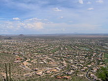
Phoenix, in Maricopa County, is Arizona's capital and largest city. Other prominent cities in the Phoenix metro area include Mesa (Arizona's third largest city), Chandler (Arizona's fourth largest city), Glendale, Peoria, Buckeye, Sun City, Sun City West, Fountain Hills, Surprise, Gilbert, El Mirage, Avondale, Tempe, Tolleson and Scottsdale, with a total metropolitan population of just over 4.7 million.[52] The average high temperature in July, 106 °F (41 °C), is one of the highest of any metropolitan area in the United States, offset by an average January high temperature of 67 °F (19 °C), the basis of its winter appeal.
Tucson, with a metro population of just over one million, is the state's second-largest city. Located in Pima County, approximately 110 miles (180 km) southeast of Phoenix, it was incorporated in 1877, making it the oldest incorporated city in Arizona. It is home to the University of Arizona. Major incorporated suburbs of Tucson include Oro Valley and Marana northwest of the city, Sahuarita south of the city, and South Tucson in an enclave south of downtown. It has an average July temperature of 100 °F (38 °C) and winter temperatures averaging 65 °F (18 °C). Saguaro National Park, just west of the city in the Tucson Mountains, is the site of the world's largest collection of Saguaro cacti.
The Prescott metropolitan area includes the cities of Prescott, Cottonwood, Camp Verde and many other towns in the 8,123 square miles (21,000 km2) of Yavapai County area. With 212,635 residents, this cluster of towns is the state's third largest metropolitan area. The city of Prescott (population 41,528) lies approximately 100 miles (160 km) northwest of the Phoenix metropolitan area. Situated in pine tree forests at an elevation of about 5,500 feet (1,700 m), Prescott enjoys a much cooler climate than Phoenix, with average summer highs around 88 °F (31 °C) and winter temperatures averaging 50 °F (10 °C).
Yuma is the center of the fourth-largest metropolitan area in Arizona. Located in Yuma County, it is near the borders of California and Mexico. It is one of the hottest cities in the United States, with an average July high of 107 °F (42 °C). (The same month's average in Death Valley is 115 °F (46 °C).) The city features sunny days about 90% of the year. The Yuma Metropolitan Statistical Area has a population of 160,000. Yuma attracts many winter visitors from all over the United States.
Flagstaff, in Coconino County, is the largest city in northern Arizona, and is at an elevation of nearly 7,000 feet (2,100 m). With its large Ponderosa pine forests, snowy winter weather and picturesque mountains, it is a stark contrast to the desert regions typically associated with Arizona. It is sited at the base of the San Francisco Peaks, the highest mountain range in the state of Arizona, which contains Humphreys Peak, the highest point in Arizona at 12,633 feet (3,851 m). Flagstaff has a strong tourism sector, due to its proximity to numerous tourist attractions including: Grand Canyon National Park, Sedona, and Oak Creek Canyon. Historic U.S. Route 66 is the main east–west street in the town. The Flagstaff metropolitan area is home to 134,421 residents and the main campus of Northern Arizona University.
Lake Havasu City, in Mohave County, known as "Arizona's playground", was developed on the Colorado River and is named after Lake Havasu. Lake Havasu City has a population of about 53,000 people. It is famous for huge spring break parties, sunsets and the London Bridge, relocated from London, England. Lake Havasu City was founded by real estate developer Robert P. McCulloch in 1963.[53] It has two colleges, Mohave Community College and ASU Colleges in Lake Havasu City.[54]
| Rank | Name | County | Pop. | Rank | Name | County | Pop. | ||
|---|---|---|---|---|---|---|---|---|---|
 Phoenix  Tucson |
1 | Phoenix | Maricopa | 1,660,272 | 11 | Yuma | Yuma | 97,908 |  Mesa  Chandler |
| 2 | Tucson | Pima | 545,975 | 12 | San Tan Valley | Pinal | 90,665 | ||
| 3 | Mesa | Maricopa | 508,958 | 13 | Avondale | Maricopa | 85,835 | ||
| 4 | Chandler | Maricopa | 257,165 | 14 | Goodyear | Maricopa | 82,835 | ||
| 5 | Scottsdale | Maricopa | 255,310 | 15 | Buckeye | Maricopa | 74,370 | ||
| 6 | Glendale | Maricopa | 250,702 | 16 | Flagstaff | Coconino | 73,964 | ||
| 7 | Gilbert | Maricopa | 248,279 | 17 | Casas Adobes | Pima | 68,919 | ||
| 8 | Tempe | Maricopa | 192,364 | 18 | Casa Grande | Pinal | 57,232 | ||
| 9 | Peoria | Maricopa | 172,259 | 19 | Lake Havasu City | Mohave | 55,090 | ||
| 10 | Surprise | Maricopa | 138,161 | 20 | Catalina Foothills | Pima | 50,202 | ||
Demographics[]

| Historical population | |||
|---|---|---|---|
| Census | Pop. | %± | |
| 1860 | 6,482 | — | |
| 1870 | 9,658 | 49.0% | |
| 1880 | 40,440 | 318.7% | |
| 1890 | 88,243 | 118.2% | |
| 1900 | 122,931 | 39.3% | |
| 1910 | 204,354 | 66.2% | |
| 1920 | 334,162 | 63.5% | |
| 1930 | 435,573 | 30.3% | |
| 1940 | 499,261 | 14.6% | |
| 1950 | 749,587 | 50.1% | |
| 1960 | 1,302,161 | 73.7% | |
| 1970 | 1,770,900 | 36.0% | |
| 1980 | 2,718,215 | 53.5% | |
| 1990 | 3,665,228 | 34.8% | |
| 2000 | 5,130,632 | 40.0% | |
| 2010 | 6,392,017 | 24.6% | |
| 2020 | 7,151,502 | 11.9% | |
| Sources: 1910–2020[56] Note that early censuses may not include Native Americans in Arizona | |||
The United States Census Bureau records Arizona's population as 7,151,502 in the 2020 Census,[5] a 12% increase since the 2010 United States Census.[56]
Arizona remained sparsely settled for most of the 19th century.[57] The 1860 census reported the population of "Arizona County" to be 6,482, of whom 4,040 were listed as "Indians", 21 as "free colored", and 2,421 as "white".[58][59] Arizona's continued population growth puts an enormous stress on the state's water supply.[60] As of 2011, 61% of Arizona's children under age one belonged to racial groups of color. [61]
The population of metropolitan Phoenix increased by 45% from 1991 through 2001, helping to make Arizona the second fastest-growing state in the U.S. in the 1990s (the fastest was Nevada).[62] As of July 2018, the population of the Phoenix area is estimated to be over 4.9 million.
According to the 2010 United States Census, Arizona had a population of 6,392,017. In 2010, illegal immigrants constituted an estimated 8% of the population. This was the second highest percentage of any state in the U.S.[63][64] Arizona has banned sanctuary cities.[65]
Metropolitan Phoenix (4.7 million) and Tucson (1.0 million) are home to about five-sixths of Arizona's people (as of the 2010 census). Metro Phoenix alone accounts for two-thirds of the state's population.
Race and ethnicity[]
In 1980, the Census Bureau reported Arizona's population as 16% Hispanic, 6% Native American, and 75% non-Hispanic white.[66] In 2010, the racial makeup of the state was:
- 73% White
- 5% Native American and Alaska Native
- 4% Black or African American
- 3% Asian
- 12% from some other race
- 3% from two or more races.
Hispanics or Latinos of any race made up 30% of the state's population. Non-Hispanic whites formed 58% of the total population.[67]
| Racial composition | 1970[68] | 1990[68] | 2000[69] | 2010[70] |
|---|---|---|---|---|
| White | 91% | 81% | 76% | 73% |
| Native | 5% | 6% | 5% | 5% |
| Black | 3% | 3% | 3% | 4% |
| Asian | 1% | 2% | 2% | 3% |
| Native Hawaiian and other Pacific Islander |
– | – | – | – |
| Other race | 1% | 9% | 12% | 12% |
| Two or more races | – | – | 3% | 3% |
This section needs to be updated. (February 2020) |
Arizona's five largest ancestry groups, as of 2009, were:[71]
- Mexican (27%)
- German (16%)
- Irish (11%)
- English (10%)
- Italian (5%)
Languages[]

| Language | Percentage of population (as of 2010)[72] |
|---|---|
| Spanish | 21% |
| Navajo | 2% |
| German | <1% |
| Chinese (including Mandarin) | <1% |
| Tagalog | <1% |
| Vietnamese | <1% |
| Other North American indigenous languages (especially indigenous languages of Arizona) | <1% |
| French | <1% |
| Arabic | <1% |
| Apache | <1% |
| Korean | <1% |

As of 2010, 73% (4,215,749) of Arizona residents age five and older spoke only English at home, while 21% (1,202,638) spoke Spanish, 2% (85,602) Navajo, <1% (22,592) German, <1% (22,426) Chinese (which includes Mandarin), <1% (19,015) Tagalog, <1% (17,603) Vietnamese, <1% (15,707) Other North American Indigenous Languages (especially indigenous languages of Arizona), and French was spoken as a main language by <1% (15,062) of the population over the age of five. In total, 27% (1,567,548) of Arizona's population age five and older spoke a mother language other than English.[72]
Arizona is home to the largest number of speakers of Native American languages in the 48 contiguous states, as more than 85,000 individuals reported speaking Navajo,[73] and 10,403 people reported Apache, as a language spoken at home in 2005.[73] Arizona's Apache County has the highest concentration of speakers of Native American Indian languages in the United States.[74]
Religion[]

In 2010, the Association of Religion Data Archives reported that the three largest denominational groups in Arizona were the Catholic Church, The Church of Jesus Christ of Latter-Day Saints and non-denominational Evangelical Protestants. The Catholic Church has the highest number of adherents in Arizona (at 930,001), followed by The Church of Jesus Christ of Latter-day Saints with 410,263 members reported[76] and then non-denominational Evangelical Protestants, reporting 281,105 adherents.[77] The religious body with the largest number of congregations is The Church of Jesus Christ of Latter-day Saints (with 836 congregations)[78] followed by the Southern Baptist Convention (with 323 congregations).
According to the Association of Religion Data Archives, the fifteen largest denominations by number of adherents in 2010 and 2000 were:[79][80]
| Religion | 2010 Population | 2000 Population |
|---|---|---|
| Catholic Church | 930,001 | 974,884 |
| The Church of Jesus Christ of Latter-day Saints | 410,263 | 251,974 |
| Non-denominational Christianity | 281,105 | 63,885[a] |
| Southern Baptist Convention | 126,830 | 138,516 |
| Assemblies of God | 123,713 | 82,802 |
| United Methodist Church | 54,977 | 53,232 |
| Christian Churches and Churches of Christ | 48,386 | 33,162 |
| Evangelical Lutheran Church in America | 42,944 | 69,393 |
| Lutheran Church–Missouri Synod | 26,322 | 24,977 |
| Presbyterian Church (U.S.A.) | 26,078 | 33,554 |
| Episcopal Church (United States) | 24,853 | 31,104 |
| Seventh-day Adventist Church | 20,924 | 11,513 |
| Church of the Nazarene | 16,991 | 18,143 |
| Lutheran Congregations in Mission for Christ | 14,350 | 0 |
| Churches of Christ | 14,151 | 14,471 |
Hinduism became the largest non-Christian religion (when combining all denominations) in 2010 with more than 32,000 adherents, followed by Judaism with more than 20,000 and Buddhism with more than 19,000.[79][81][82]
Economy[]

The 2011 total gross state product was $259 billion. This figure gives Arizona a larger economy than such countries as Ireland, Finland, and New Zealand.[dubious ] The composition of the state's economy is moderately diverse; although health care, transportation and the government remain the largest sectors.
The state's per capita income is $40,828, ranking 39th in the U.S. The state had a median household income of $50,448, making it 22nd in the country and just below the U.S. national mean.[83] Early in its history, Arizona's economy relied on the "five C's": copper (see Copper mining in Arizona), cotton, cattle, citrus, and climate (tourism). Copper is still extensively mined from many expansive open-pit and underground mines, accounting for two-thirds of the nation's output.
Employment[]
- Total employment (2016): 2,379,409
- Total employer establishments (2016): 139,134[84]
The state government is Arizona's largest employer, while Banner Health is the state's largest private employer, with more than 39,000 employees (2016). As of August 2020, the state's unemployment rate was 5.9%.[85]
The largest employment sectors in Arizona are (August 2020, Nonfarm Employment):[85]
| Sector | Employees |
|---|---|
| Trade, transportation, and utilities | 553,300 |
| Education and health services | 459,400 |
| Government | 430,400 |
| Professional and business services | 419,200 |
| Leisure and hospitality | 269,400 |
| Financial activities | 231,900 |
| Manufacturing | 170,900 |
| Construction | 169,900 |
| Other services | 95,600 |
| Information | 46,100 |
| Mining and logging | 13,300 |
Largest employers[]
According to The Arizona Republic, the largest private employers in the state as of 2019 were:[86]
| Rank | Company | Employees | Industry |
|---|---|---|---|
| 1 | Banner Health | 44,718 | Healthcare |
| 2 | Walmart Stores, Inc. | 34,071 | Discount retailer |
| 3 | Kroger Co. | 20,530 | Grocery stores |
| 4 | Wells Fargo & Co. | 16,161 | Financial services |
| 5 | Albertsons Inc. | 14,500 | Grocery stores, retail drugstores |
| 6 | McDonald's Corp. | 13,000 | Food service |
| 7 | CVS Health | 12,100 | Healthcare |
| 8 | Raytheon Co. | 12,000 | Defense |
| 9 | HonorHealth | 11,919 | Healthcare |
| 10 | Dignity Health | 10,562 | Healthcare |
| 11 | Intel Corp. | 10,400 | Semiconductor manufacturing |
| 12 | Home Depot Inc. | 10,200 | Retail home improvement |
| 13 (tie) | JP Morgan Chase & Co. | 10,000 | Financial services |
| American Airlines | 10,000 | Airline | |
| 15 | Tenet Healthcare | 9,483 | Healthcare |
| 16 | Bank of America Corp. | 9,200 | Financial services |
| 17 | Freeport-McMoRan Copper & Gold Inc. | 8,759 | Mining |
| 18 | Bashas' Supermarkets | 8,519 | Grocery stores |
| 19 | Amazon.com | 8,500 | Online Shopping |
| 20 | Target Corp. | 8,400 | Discount retailer |
| 21 | Honeywell International Inc. | 7,792 | Aerospace manufacturing |
| 22 | Circle K Corp. | 7,478 | Convenience stores |
| 23 | Mayo Foundation | 7,436 | Healthcare |
| 24 | State Farm | 7,200 | Insurance |
| 25 | UnitedHealthcare | 7,194 | Healthcare |
Taxation[]
Tax is collected by the Arizona Department of Revenue.[87]
Arizona collects personal income taxes in five brackets: 2.59%, 2.88%, 3.36%, 4.24% and 4.54%.[88] The state transaction privilege tax is 5.6%; however, county and municipal sales taxes generally add an additional 2%.
In 2020, Arizona voters approved Proposition 208 to create an additional income tax bracket of 8% for incomes over $250,000 (single filers) and $500,000 (joint filers).[89] The Goldwater Institute filed a lawsuit challenging it, but it was rejected by Maricopa County Arizona Superior Court judge John Hannah Jr.[90][91]
The state rate on transient lodging (hotel/motel) is 7.27%. The state of Arizona does not levy a state tax on food for home consumption or on drugs prescribed by a licensed physician or dentist. However, some cities in Arizona do levy a tax on food for home consumption.
All fifteen Arizona counties levy a tax. Incorporated municipalities also levy transaction privilege taxes which, with the exception of their hotel/motel tax, are generally in the range of 1-to-3%. These added assessments could push the combined sales tax rate to as high as 10.7%.[citation needed]
| Single | Tax rate | Joint | Tax rate |
|---|---|---|---|
| 0 – $10,000 | 2.59% | 0 – $20,000 | 2.59% |
| $10,000 – $25,000 | 2.88% | $20,001 – $50,000 | 2.88% |
| $25,000 – $50,000 | 3.36% | $50,001 – $100,000 | 3.36% |
| $50,000 – $150,001 | 4.24% | $100,000 – $300,001 | 4.24% |
| $150,001 + | 4.54% | $300,001 + | 4.54% |
Transportation[]
This section needs additional citations for verification. (February 2021) |

Highways[]
Interstate highways[]
![]() I-8 |
I-8 | ![]() I-10 |
I-10 | ![]() Future I-11 |
Future I-11 | ![]() I-15 |
I-15 | ![]() I-17 |
I-17 | ![]() I-19 |
I-19 | ![]() I-40
I-40
U.S. routes[]
![]() US 60 |
US 60 | ![]() US 64 |
US 64 | ![]() Historic US 66 |
Historic US 66 | ![]() US 70 |
US 70 | ![]() Historic US 80 |
Historic US 80 | ![]() US 89 |
US 89 | ![]() US 89A |
US 89A | ![]() US 91 |
US 91 | ![]() US 93 |
US 93 | ![]() US 95 |
US 95 | ![]() US 160 |
US 160 | ![]() US 163 |
US 163 | ![]() US 180 |
US 180 | ![]() US 191
US 191
Main Interstate routes include I-17, and I-19 traveling north–south, I-8, I-10, and I-40, traveling east–west, and a short stretch of I-15 traveling northeast–southwest through the extreme northwestern corner of the state. In addition, the various urban areas are served by complex networks of state routes and highways, such as the Loop 101, which is part of Phoenix's vast freeway system.
Public transportation, Amtrak, and intercity bus[]
The Phoenix and Tucson metropolitan areas are served by public bus transit systems. Yuma and Flagstaff also have public bus systems. Greyhound Lines serves Phoenix, Tucson, Flagstaff, Yuma, and several smaller communities statewide.
A light rail system, called Valley Metro Rail, was completed in December 2008; it connects Central Phoenix with the nearby cities of Mesa and Tempe.
In Tucson, the Sun Link streetcar system travels through the downtown area, connecting the main University of Arizona campus with Mercado San Agustin on the western edge of downtown Tucson. Sun Link, loosely based on the Portland Streetcar, launched in July 2014.[92]
Amtrak Southwest Chief route serves the northern part of the state, stopping at Winslow, Flagstaff, Williams and Kingman. The Texas Eagle and Sunset Limited routes serve South-Central Arizona, stopping at Tucson, Maricopa, Yuma and Benson. Phoenix lost Amtrak service in 1996 with the discontinuation of the Desert Wind, and now an Amtrak bus runs between Phoenix and the station in Maricopa. As of 2021, Amtrak has proposed to restore rail service between Phoenix and Tucson.[93]
Aviation[]
Airports with regularly scheduled commercial flights include: Phoenix Sky Harbor International Airport (IATA: PHX, ICAO: KPHX) in Phoenix (the state's largest airport and the major international airport); Tucson International Airport (IATA: TUS, ICAO: KTUS) in Tucson; Phoenix-Mesa Gateway Airport (IATA: AZA, ICAO: KIWA) in Mesa; Yuma International Airport (IATA: NYL, ICAO: KNYL) in Yuma; Prescott Municipal Airport (PRC) in Prescott; Flagstaff Pulliam Airport (IATA: FLG, ICAO: KFLG) in Flagstaff, and Grand Canyon National Park Airport (IATA: GCN, ICAO: KGCN, FAA: GCN), a small, but busy, single-runway facility providing tourist flights, mostly from Las Vegas. Phoenix Sky Harbor is the world's 7th busiest airport in terms of aircraft movements and 17th for passenger traffic.[94][95]
Other significant airports without regularly scheduled commercial flights include Scottsdale Municipal Airport (IATA: SCF, ICAO: KSDL) in Scottsdale, and Deer Valley Airport (IATA: DVT, ICAO: KDVT, FAA: DVT) home to two flight training academies and the nation's busiest general aviation airport.[96]
Law and government[]
This section needs additional citations for verification. (February 2021) |
Capitol complex[]
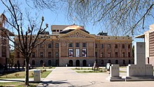
The capital of Arizona is Phoenix. The original Capitol building, with its distinctive copper dome, was dedicated in 1901 (construction was completed for $136,000 in 1900) when the area was a territory. Phoenix became the official state capital with Arizona's admission to the union in 1912.
The House of Representatives and Senate buildings were dedicated in 1960, and an Executive Office Building was dedicated in 1974 (the ninth floor of this building is where the Office of the Governor is located). The original Capitol building was converted into a museum.
The Capitol complex is fronted and highlighted by the richly landscaped Wesley Bolin Memorial Plaza, named after Wesley Bolin, a governor who died in office in the 1970s. The site also includes many monuments and memorials, including the anchor and signal mast from the USS Arizona (one of the U.S. Navy ships sunk in Pearl Harbor) and a granite version of the Ten Commandments.
State legislative branch[]
The Arizona Legislature is bicameral and consists of a thirty-member Senate and a 60-member House of Representatives. Each of the thirty legislative districts has one senator and two representatives. Legislators are elected for two-year terms.
Each Legislature covers a two-year period. The first session following the general election is known as the first regular session, and the session convening in the second year is known as the second regular session. Each regular session begins on the second Monday in January and adjourns sine die (terminates for the year) no later than Saturday of the week in which the 100th day from the beginning of the regular session falls. The President of the Senate and Speaker of the House, by rule, may extend the session up to seven additional days. Thereafter, the session can be extended only by a majority vote of members present of each house.
The majority party is the Republican Party, which has held power in both houses since 1993. The Democratic Party picked up several legislative seats in recent elections, bringing both chambers one seat away from being equally divided as of 2021.
Arizona state senators and representatives are elected for two-year terms and are limited to four consecutive terms in a chamber, though there is no limit on the total number of terms. When a lawmaker is term-limited from office, it is common for him or her to run for election in the other chamber.
The fiscal year 2006–07 general fund budget, approved by the Arizona Legislature in June 2006, was slightly less than $10 billion. Besides the money spent on state agencies, it also included more than $500 million in income and property tax cuts, pay raises for government employees, and additional funding for the K–12 education system.
State executive branch[]
| State of Arizona elected officials | |
| Governor | Doug Ducey (R) |
| Secretary of State | Katie Hobbs (D) |
| Attorney General | Mark Brnovich (R) |
| State Treasurer | Kimberley Yee (R) |
| Superintendent of Public Instruction | Kathy Hoffman (D) |
| State Mine Inspector | Joe Hart (R) |
| Corporation Commissioner |
|
| Speaker of the House |
Rusty Bowers (R) |
| President of the Senate |
Karen Fann (R) |
Arizona's executive branch is headed by a governor, who is elected to a four-year term. The governor may serve any number of terms, though no more than two in a row. Arizona is one of the few states that has no governor's mansion. During their term, the governors reside within their private residence, with executive offices housed in the executive tower at the state capitol. The governor of Arizona is Doug Ducey (R).
Governor Jan Brewer assumed office in 2009 after Janet Napolitano had her nomination by Barack Obama for Secretary of Homeland Security confirmed by the United States Senate.[97] Arizona has had four female governors, more than any other state.
Other elected executive officials include the Secretary of State, State Treasurer, State Attorney General, Superintendent of Public Instruction, State Mine Inspector and a five-member Corporation Commission. All elected officials hold a term of four years, and are limited to two consecutive terms (except the office of the State Mine Inspector, which is limited to four terms).[98]
Arizona is one of five states that do not have a lieutenant governor. The elected secretary of state is first in line to succeed the governor in the event of death, disability, resignation, or removal from office. If appointed, the Secretary of State is not eligible and the next governor is selected from the next eligible official in the line of succession, including the attorney general, state treasurer and superintendent of public instruction. Since 1977, four secretaries of state and one attorney general have succeeded to Arizona's governorship.
State judicial branch[]
The Arizona Supreme Court is the highest court in Arizona, consisting of a chief justice, a vice chief justice, and five associate justices. Justices are appointed by the governor from a list recommended by a bipartisan commission and must be sustained in office by election after the first two years following their appointment. Subsequent sustaining elections occur every six years. The supreme court has appellate jurisdiction in death penalty cases, but nearly all other appellate cases go through the Arizona Court of Appeals first. The court has original jurisdiction in a few other circumstances, as outlined in the state constitution. The court meets in the Arizona Supreme Court Building at the capitol complex (at the southern end of Wesley Bolin Plaza).
The Arizona Court of Appeals, subdivided into two divisions, is the intermediate court in the state. Division One is based in Phoenix, consists of sixteen judges, and has jurisdiction in the Western and Northern regions of the state, along with the greater Phoenix area. Division Two is based in Tucson, consists of six judges, and has jurisdiction over the Southern regions of the state, including the Tucson area. Judges are selected in a method similar to the one used for state supreme court justices.
Each county of Arizona has a superior court, the size and organization of which are varied and generally depend on the size of the particular county.
Counties[]

Arizona is divided into 15 counties, ranging in size from 1,238 square miles (3,210 km2) to 18,661 square miles (48,330 km2).
| hideArizona counties | ||||||
|---|---|---|---|---|---|---|
| County name | County seat | Founded | 2020 population[99] | Percent of total | Area (sq. mi.) | Percent of total |
| Apache | St. Johns | February 24, 1879 | 66,021 | 0.92% | 11,218 | 9.84% |
| Cochise | Bisbee | February 1, 1881 | 125,447 | 1.75% | 6,219 | 5.46% |
| Coconino | Flagstaff | February 18, 1891 | 145,101 | 2.03% | 18,661 | 16.37% |
| Gila | Globe | February 8, 1881 | 53,272 | 0.74% | 4,796 | 4.21% |
| Graham | Safford | March 10, 1881 | 38,533 | 0.54% | 4,641 | 4.07% |
| Greenlee | Clifton | March 10, 1909 | 9,563 | 0.13% | 1,848 | 1.62% |
| La Paz | Parker | January 1, 1983 | 16,557 | 0.23% | 4,513 | 3.96% |
| Maricopa | Phoenix | February 14, 1871 | 4,420,568 | 61.81% | 9,224 | 8.09% |
| Mohave | Kingman | November 9, 1864 | 213,267 | 2.98% | 13,470 | 11.82% |
| Navajo | Holbrook | March 21, 1895 | 106,717 | 1.49% | 9,959 | 8.74% |
| Pima | Tucson | November 9, 1864 | 1,043,433 | 14.59% | 9,189 | 8.06% |
| Pinal | Florence | February 1, 1875 | 425,264 | 5.95% | 5,374 | 4.71% |
| Santa Cruz | Nogales | March 15, 1899 | 47,669 | 0.67% | 1,238 | 1.09% |
| Yavapai | Prescott | November 9, 1864 | 236,209 | 3.30% | 8,128 | 7.13% |
| Yuma | Yuma | November 9, 1864 | 203,881 | 2.85% | 5,519 | 4.84% |
| Totals: 15 | 7,151,502 | 113,997 | ||||
Federal representation[]
Arizona's two United States Senators are Kyrsten Sinema (D) and Mark Kelly (D). Kelly succeeded Martha McSally who was appointed by Governor Doug Ducey following the resignation of Jon Kyl who himself was appointed by Ducey after the death of John McCain in late 2018.
As of the start of the 115th Congress, Arizona's representatives in the United States House of Representatives are Tom O'Halleran (D-1), Ann Kirkpatrick (D-2), Raul Grijalva (D-3), Paul Gosar (R-4), Andy Biggs (R-5), David Schweikert (R-6), Ruben Gallego (D-7), Debbie Lesko (R-8), and Greg Stanton (D-9). Arizona gained a ninth seat in the House of Representatives due to redistricting based on Census 2010.
Political culture[]
It has been suggested that this section be split out into another article titled Politics of Arizona. (Discuss) (September 2020) |
| Voter Registration as of July 2021[100] | |||||
|---|---|---|---|---|---|
| Party | Number of voters | Percentage | |||
| Republican | 1,499,862 | 34.72% | |||
| Other | 1,408,606 | 32.60% | |||
| Democratic | 1,374,540 | 31.82% | |||
| Libertarian | 37,364 | 0.86% | |||
| Total | 4,320,372 | 100% | |||

From statehood through the late 1940s, Arizona was primarily dominated by the Democratic Party. During this time, the Democratic candidate for the presidency carried the state each election, the only exceptions being the elections of 1920, 1924 and 1928—all three were national Republican landslides.
In 1924, Congress had passed a law granting citizenship and suffrage to all Native Americans, some of whom had previously been excluded as members of tribes on reservations. Legal interpretations of Arizona's constitution prohibited Native Americans living on reservations from voting, classifying them as being under "guardianship".[36] This interpretation was overturned as being incorrect and unconstitutional in 1948 by the Arizona Supreme Court, following a suit by World War II Indian veterans and Harry Austin, both of the Fort McDowell Yavapai Nation. The landmark case is Harrison and Austin v. Laveen. After the men were refused the opportunity to register in Maricopa County, they filed suit against the registrar. The National Congress of American Indians, the Department of Justice, the Department of the Interior, and the American Civil Liberties Union all filed amicus curiae (friends of the court) briefs in the case. The State Supreme Court established the rights of Native Americans to vote in the state; at the time, they comprised about 11% of the population.[36] That year, a similar provision was overturned in New Mexico when challenged by another Indian veteran in court. These were the only two states that had continued to prohibit Native Americans from voting.[101][36]
Arizona voted Republican in every presidential election from 1952 to 1992, with Richard Nixon and Ronald Reagan winning the state by particularly large margins. During this forty-year span, it was the only state not to be carried by a Democrat at least once.
Democrat Lyndon Johnson, in 1964, lost the state by fewer than 5,000 votes to Arizona Senator and native Barry Goldwater. (This was the most closely contested state in what was otherwise a landslide victory for Johnson that year.) Democrat Bill Clinton ended this streak in 1996, when he won Arizona by a little over two percentage points (Clinton had previously come within less than two percent of winning Arizona's electoral votes in 1992). From 2000 until 2016, the majority of the state continued to support Republican presidential candidates by solid margins. In the 2020 United States presidential election, Joe Biden again broke the streak by becoming the first Democratic presidential candidate to win Arizona since 1996.[102]
Since the late 20th century, the Republican Party has also dominated Arizona politics in general. The fast-growing Phoenix and Tucson suburbs became increasingly friendly to Republicans from the 1950s onward. During this time, many "Pinto Democrats", or conservative Democrats from rural areas, became increasingly willing to support Republicans at the state and national level. While the state normally supports Republicans at the federal level, Democrats are often competitive in statewide elections. Two of the last six governors have been Democrats.
| Year | Republican | Democratic |
|---|---|---|
| 2020 | 49.0% 1,661,686 | 49.4% 1,672,143 |
| 2016 | 48.1% 1,252,401 | 44.6% 1,161,167 |
| 2012 | 53.5% 1,233,654 | 44.5% 1,025,232 |
| 2008 | 53.4% 1,230,111 | 44.9% 1,034,707 |
| 2004 | 54.7% 1,104,294 | 44.3% 893,524 |
| 2000 | 50.9% 781,652 | 44.7% 685,341 |
| 1996 | 44.3% 622,073 | 46.5% 653,288 |
| 1992 | 38.4% 572,086 | 36.5% 543,050 |
| 1988 | 59.9% 702,541 | 38.7% 454,029 |
| 1984 | 66.4% 681,416 | 32.5% 333,854 |
| 1980 | 60.6% 529,688 | 28.2% 246,843 |
| 1976 | 56.3% 418,642 | 39.8% 295,602 |
On March 4, 2008, Senator John McCain effectively clinched the Republican nomination for 2008, becoming the first major party presidential nominee from the state since Barry Goldwater in 1964.
Arizona politics are dominated by a longstanding rivalry between its two largest counties, Maricopa and Pima—home to Phoenix and Tucson, respectively. The two counties have almost 75 percent of the state's population and cast almost 80 percent of the state's vote. They also elect a substantial majority of the state legislature.
Maricopa County is home to almost 60 percent of the state's population, and most of the state's elected officials live there. Before Joe Biden won Maricopa County in 2020, it had voted Republican in every presidential election since 1948. This includes the 1964 run of native son Barry Goldwater; he would not have carried his home state without his 20,000-vote margin in Maricopa County. Similarly, while McCain won Arizona by eight percentage points in 2008, aided by his 130,000-vote margin in Maricopa County.
In contrast, Pima County, home to Tucson, and most of southern Arizona have historically voted more Democratic. While Tucson's suburbs lean Republican, they hold to a somewhat more moderate brand of Republicanism than is common in the Phoenix area.

Arizona rejected a same-sex marriage ban in a referendum as part of the 2006 elections. Arizona was the first state in the nation to do so. Same-sex marriage was not recognized in Arizona, but this amendment would have denied any legal or financial benefits to unmarried homosexual or heterosexual couples.[103] In 2008, Arizona voters passed Proposition 102, an amendment to the state constitution to define marriage as a union of one man and one woman. It passed by a more narrow majority than similar votes in a number of other states.[104]
In 2010, Arizona passed SB 1070, called the toughest illegal immigration legislation in the nation. A fierce debate erupted between supporters and detractors of the law.[105] The United States Supreme Court struck down portions of the Arizona law, which required all immigrants to carry immigration papers at all times, in Arizona v. United States.[106]
The West Virginia teachers' strike in 2018 inspired teachers in other states, including Arizona, to take similar action.[107]
Same-sex marriage and civil unions[]
In 2006, Arizona became the first state in the United States to reject a proposition, Prop 107, that would have banned same-sex marriage and civil unions.[108] However, in 2008, Arizona voters approved of Prop 102, a constitutional amendment that prohibited same-sex marriage but not other unions.[109] Prior to same-sex marriage being legal, the City of Bisbee became the first jurisdiction in Arizona to approve of civil unions.[110] The state's Attorney General at the time, Tom Horne, threatened to sue, but rescinded the threat once Bisbee amended the ordinance; Bisbee approved of civil unions in 2013.[111] The municipalities of Clarkdale, Cottonwood, Jerome, Sedona, and Tucson also passed civil unions.[112]
A November 2011 Public Policy Polling survey found 44% of Arizona voters supported the legalization of same-sex marriage, while 45% opposed it and 12% were not sure. A separate question on the same survey found 72% of respondents supported legal recognition of same-sex couples, with 40% supporting same-sex marriage, 32% supporting civil unions, 27% opposing all legal recognition and 1% not sure. Arizona Proposition 102, known by its supporters as the Marriage Protection Amendment, appeared as a legislatively referred constitutional amendment on the November 4, 2008 ballot in Arizona, where it was approved: 56–43%. It amended the Arizona Constitution to define marriage as between one man and one woman.[113]
On October 17, 2014, Arizona Attorney General Tom Horne announced his office would no longer object to same-sex marriage, in response to a U.S. District Court Ruling on Arizona Proposition 102. On that day, each county's Clerk of the Superior Court began to issue same-sex marriage licenses, and Arizona became the 31st state to legalize same-sex marriage.
Education[]
This section needs additional citations for verification. (February 2021) |
Elementary and secondary education[]
Public schools in Arizona are separated into about 220 local school districts which operate independently, but are governed in most cases by elected county school superintendents; these are in turn overseen by the Arizona State Board of Education and the Arizona Department of Education. A state Superintendent of Public Instruction (elected in partisan elections every even-numbered year when there is not a presidential election, for a four-year term). In 2005, a School District Redistricting Commission was established with the goal of combining and consolidating many of these districts.
Higher education[]
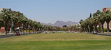


Arizona is served by three public universities: The University of Arizona, Arizona State University, and Northern Arizona University. These schools are governed by the Arizona Board of Regents.
Private higher education in Arizona is dominated by a large number of for-profit and "chain" (multi-site) universities.[114]
Embry–Riddle Aeronautical University, Prescott and Prescott College are Arizona's only non-profit four-year private colleges.[115]
Arizona has a wide network of two-year vocational schools and community colleges. These colleges were governed historically by a separate statewide board of directors but, in 2002, the state legislature transferred almost all oversight authority to individual community college districts.[116] The Maricopa County Community College District includes 11 community colleges throughout Maricopa County and is one of the largest in the nation.
Public universities in Arizona[]
- Arizona State University, (Sun Devils) Tempe/Phoenix/Mesa/Glendale/Lake Havasu
- Northern Arizona University, (Lumberjacks) Flagstaff/Yuma/Prescott
- University of Arizona, (Wildcats) Tucson/Sierra Vista, MD college in downtown Phoenix and UA Agricultural Center in Yuma/Maricopa
Private colleges and universities in Arizona[]
- American Indian College
- Carrington College
- Arizona Christian University
- Art Center College of Design
- Art Institute of Tucson
- Art Institute of Phoenix
- A.T. Still University
- Brookline College
- Brown Mackie College
- Embry-Riddle Aeronautical University
- Grand Canyon University
- Midwestern University
- Northcentral University
- Ottawa University
- Park University
- University of Phoenix
- Penn Foster College[117]
- Prescott College
- Southwest College of Naturopathic Medicine
- Thunderbird School of Global Management
- University of Advancing Technology
- Western Governors University
- Western International University
- Conservatory of Recording Arts and Sciences
Community colleges[]
- Arizona Western College
- Central Arizona College
- Cochise College
- Coconino Community College
- Diné College
- Eastern Arizona College
- Chandler-Gilbert Community College
- Estrella Mountain Community College
- GateWay Community College
- Glendale Community College
- Maricopa County Community College District
- Mesa Community College
- Mohave Community College
- Northland Pioneer College
- Paradise Valley Community College
- Phoenix College
- Pima Community College
- Rio Salado Community College
- Scottsdale Community College
- South Mountain Community College
- Yavapai College
Art and culture[]
This section needs additional citations for verification. (February 2021) |
Visual arts and museums[]
Phoenix Art Museum, on the historic Central Avenue Corridor in Phoenix, is the Southwest's largest collection of visual art from across the world. The museum displays international exhibitions alongside the museum's collection of more than 18,000 works of American, Asian, European, Latin American, Western American, modern and contemporary art, and fashion design. With a community education mandate since 1951, Phoenix Art Museum holds a year-round program of festivals, live performances, independent art films and educational programs. The museum also has PhxArtKids, an interactive space for children; photography exhibitions through the museum's partnership with the Center for Creative Photography; the landscaped Sculpture Garden and dining at Arcadia Farms.
Arizona is a recognized center of Native American art, with a number of galleries showcasing historical and contemporary works. The Heard Museum, also in Phoenix, is a major repository of Native American art. Some of the signature exhibits include a full Navajo hogan, the Mareen Allen Nichols Collection containing 260 pieces of contemporary jewelry, the Barry Goldwater Collection of 437 historic Hopi kachina dolls, and an exhibit on the 19th-century boarding school experiences of Native Americans. The Heard Museum has about 250,000 visitors a year.
Sedona, Jerome, and Tubac are known as budding artist colonies, and small arts scenes exist in the larger cities and near the state universities.
Film[]

Several major Hollywood films, such as Billy Jack, U Turn, Waiting to Exhale, Just One of the Guys, Can't Buy Me Love, Bill & Ted's Excellent Adventure, The Scorpion King, The Banger Sisters, Used Cars, and Raising Arizona have been made there (as have many Westerns). The 1993 science fiction movie Fire in the Sky, based on a reported alien abduction in the town of Snowflake, was set in Snowflake. It was filmed in the Oregon towns of Oakland, Roseburg, and Sutherlin.
The 1974 film Alice Doesn't Live Here Anymore, for which Ellen Burstyn won the Academy Award for Best Actress, and also starring Kris Kristofferson, was set in Tucson. The climax of the 1977 Clint Eastwood film The Gauntlet takes place in downtown Phoenix. The final segments of the 1984 film Starman take place at Meteor Crater outside Winslow. The Jeff Foxworthy comedy documentary movie Blue Collar Comedy Tour was filmed almost entirely at the Dodge Theatre. Some of Alfred Hitchcock's classic film Psycho was shot in Phoenix, the ostensible home town of the main character.
Some of the television shows filmed or set in Arizona include The New Dick Van Dyke Show, Medium, Alice, The First 48, Insomniac with Dave Attell, Cops, and America's Most Wanted. The TV sitcom Alice, which was based on the movie was set in Phoenix. Twilight had passages set in Phoenix at the beginning and the end of the film.
Music[]
Arizona is prominently featured in the lyrics of many Country and Western songs, such as Jamie O'Neal's hit ballad "There Is No Arizona". George Strait's "Oceanfront Property" uses "ocean front property in Arizona" as a metaphor for a sucker proposition. The line "see you down in Arizona Bay" is used in a Tool song in reference to the possibility (expressed as a hope by comedian Bill Hicks) that Southern California will one day fall into the ocean. Glen Campbell, a notable resident, popularized the song "By The Time I Get To Phoenix".

"Arizona" was the title of a popular song recorded by Mark Lindsay. Arizona is mentioned by the hit song "Take It Easy", written by Jackson Browne and Glenn Frey and performed by the Eagles. Arizona is also mentioned in the Beatles' song "Get Back", credited to John Lennon and Paul McCartney; McCartney sings: "JoJo left his home in Tucson, Arizona, for some California grass." "Carefree Highway", released in 1974 by Gordon Lightfoot, takes its name from Arizona State Route 74 north of Phoenix.[118]
Arizona's budding music scene is helped by emerging bands, as well as some well-known artists. The Gin Blossoms, Chronic Future, Roger Clyne and the Peacemakers, Jimmy Eat World, Caroline's Spine, and others began their careers in Arizona. Also, a number of punk and rock bands got their start in Arizona, including JFA, The Feederz, Sun City Girls, The Meat Puppets, The Maine, The Summer Set, and more recently Authority Zero and Digital Summer.
Arizona also has many singers and other musicians. Singer, songwriter and guitarist Michelle Branch is from Sedona. Chester Bennington, the former lead vocalist of Linkin Park, and mash-up artist DJ Z-Trip are both from Phoenix. One of Arizona's better known musicians is shock rocker Alice Cooper, who helped define the genre. Maynard James Keenan, the lead singer of the bands Tool, A Perfect Circle, and Puscifer, calls the town of Cornville home.
Other notable singers include country singers Dierks Bentley and Marty Robbins, folk singer Katie Lee, Fleetwood Mac's Stevie Nicks, CeCe Peniston, Rex Allen, 2007 American Idol winner Jordin Sparks, and Linda Ronstadt.
Arizona is also known for its heavy metal scene, which is centered in and around Phoenix. In the early to mid-1990s, it included bands such as Job for a Cowboy, Knights of the Abyss, Greeley Estates, Eyes Set To Kill, blessthefall, The Word Alive, The Dead Rabbitts, and Abigail Williams. The band Soulfly calls Phoenix home and Megadeth lived in Phoenix for about a decade. Beginning in and around 2009, Phoenix began to host a burgeoning desert rock and sludge metal underground, (ala' Kyuss in 1990s California) led by bands like Wolves of Winter, Asimov, and Dead Canyon.
American composer Elliott Carter composed his first String Quartet (1950–51) while on sabbatical (from New York) in Arizona. The quartet won a Pulitzer Prize and other awards and is now a staple of the string quartet repertoire.[citation needed]
Sports[]
| Club | Sport | League | Championships |
|---|---|---|---|
| Arizona Cardinals | American football | National Football League | 2 (1925, 1947) |
| Phoenix Suns | Basketball | National Basketball Association | 0 |
| Arizona Diamondbacks | Baseball | Major League Baseball | 1 (2001) |
| Arizona Coyotes | Ice hockey | National Hockey League | 0 |
| Arizona Rattlers | Indoor football | Indoor Football League | 6 (1994, 1997, 2012, 2013, 2014, 2017) |
| Phoenix Rising FC | Soccer | USL Championship | 0 |
| Phoenix Mercury | Basketball | Women's National Basketball Association | 3 (2007, 2009, 2014) |
| Tucson Roadrunners | Ice hockey | American Hockey League | 0 |

State Farm Stadium hosted Super Bowl XLII on February 3, 2008, and Super Bowl XLIX on February 1, 2015. The stadium is also scheduled to host Super Bowl LVII tentatively scheduled for February 5, 2023.
Due to its numerous golf courses, Arizona is home to several stops on the PGA Tour, most notably the Phoenix Open, held at the TPC of Scottsdale, and the WGC-Accenture Match Play Championship at the Ritz-Carlton Golf Club in Marana.
Auto racing is another sport known in the state. Phoenix Raceway in Avondale is home to NASCAR race weekends twice a year. Firebird International Raceway near Chandler is home to drag racing and other motorsport events.
College sports[]
College sports are also prevalent in Arizona. The Arizona State Sun Devils and the Arizona Wildcats belong to the Pac-12 Conference while the Northern Arizona Lumberjacks compete in the Big Sky Conference and the Grand Canyon Antelopes compete in the Western Athletic Conference. The rivalry between Arizona State Sun Devils and the Arizona Wildcats predates Arizona's statehood, and is the oldest rivalry in the NCAA.[119] The Territorial Cup, first awarded in 1889 and certified as the oldest trophy in college football,[120] is awarded to the winner of the annual football game between the two schools.
Arizona also hosts several college football bowl games. The Fiesta Bowl, originally held at Sun Devil Stadium, is now held at State Farm Stadium in Glendale. The Fiesta Bowl is part of the new College Football Playoff (CFP). University of Phoenix Stadium was also home to the 2007 and 2011 BCS National Championship Games.

State Farm Stadium hosted the Final Four of the NCAA Division I Men's Basketball Tournament in 2017 and is scheduled to host it again in 2024.
Baseball[]
Arizona is a popular location for Major League Baseball spring training, as it is the site of the Cactus League. Spring training was first started in Arizona in 1947 when Brewers owner Veeck sold them in 1945 but went onto purchase the Cleveland Indians in 1946. He decided to train the Cleveland Indians in Tucson and convinced the New York Giants to give Phoenix a try. Thus the Cactus League was born.[121]
On March 9, 1995, Arizona was awarded a franchise to begin to play for the 1998 season. A $130 million franchise fee was paid to Major League Baseball and on January 16, 1997, the Diamondbacks were officially voted into the National League.
Since their debut, the Diamondbacks have won five National League West titles, one National League Championship pennant, and the 2001 World Series.
Notable people[]
See also[]
- Outline of Arizona
- Index of Arizona-related articles
Notes[]
- ^ In 2000, this designation was broken into two groups: Independent, Non-Charismatic Churches (34,130 adherents) and Independent, Charismatic Churches (29,755 adherents)
References[]
- ^ "2010 Census State Area Measurements and Internal Point Coordinates". U.S. Census Bureau. Retrieved February 14, 2012.
- ^ "Frisco". NGS data sheet. U.S. National Geodetic Survey. Retrieved October 20, 2011.
- ^ Jump up to: a b "Elevations and Distances in the United States". United States Geological Survey. 2001. Archived from the original on October 15, 2011. Retrieved December 28, 2011.
- ^ Jump up to: a b Elevation adjusted to North American Vertical Datum of 1988.
- ^ Jump up to: a b "Change in Resident Population of the 50 States, the District of Columbia, and Puerto Rico: 1910 to 2020" (PDF). Census.gov. United States Census Bureau. Archived (PDF) from the original on April 26, 2021. Retrieved April 27, 2020.
- ^ "Median Annual Household Income". The Henry J. Kaiser Family Foundation. Archived from the original on December 20, 2016. Retrieved December 9, 2016.
- ^ "Arizona—Definition and More from the Free Merriam-Webster Dictionary". Merriam-webster.com. April 25, 2007. Archived from the original on January 12, 2012. Retrieved December 28, 2011.
- ^ "Arizona in Navajo". Glosbe.com. Retrieved November 6, 2020.
- ^ Jump up to: a b Saxton, Dean; Saxton, Lucille; Enos, Susie (1983). Dictionary: Tohono O'odham/Pima to English, English to Tohono O'odham/Pima. Tucson: University of Arizona Press.
- ^ "The 50 biggest companies in Arizona". AZBigMedia. Retrieved January 24, 2021.
- ^ "All about Arizona". Sheppard Software. Archived from the original on November 20, 2017. Retrieved September 21, 2010.
- ^ Bright, William (2004). Native American Place Names of the United States. Norman: University of Oklahoma Press. p. 47.
- ^ Kitt, E. O.; Pearce, T. M. (1952). "Arizona Place Name Records". Western Folklore. 11 (4): 284–287. doi:10.2307/1496233. JSTOR 1496233.
- ^ Harper, Douglas. "Arizona". Online Etymology Dictionary. Archived from the original on July 28, 2011. Retrieved December 28, 2011.
- ^ McClintock, James (1916). Arizona, Prehistoric, Aboriginal, Pioneer, Modern: The Nation's Youngest Commonwealth within a Land of Ancient Culture. Chicago: The S.J. Clarke Publishing Co. Archived from the original on February 1, 2015. Retrieved November 9, 2019.
- ^ Jump up to: a b Thompson, Clay (February 11, 2007). "No, 'arid zone' not the basis of state's name". The Arizona Republic. Retrieved December 29, 2014.
- ^ Thompson, Clay (February 25, 2007). "A sorry state of affairs when views change". The Arizona Republic. Archived from the original on June 4, 2012. Retrieved March 3, 2007.
- ^ Turner, Jim. "How Arizona did NOT Get its Name". Arizona Historical Society. Archived from the original on October 13, 2007. Retrieved March 3, 2007.
- ^ Garate, Donald (2005). "Arizonac, a twentieth-century myth". Journal of Arizona History. 46 (2): 161–184.
- ^ "The Meaning of Arizona". Arizona Almanac. Arizona State Library Archives & Public Records. Archived from the original on July 16, 2019. Retrieved March 20, 2019.
- ^ Martínez Laínez, Fernando and Canales Torres, Carlos. Banderas lejanas: La exploración, conquista y defensa por parte de España del Territorio de los actuales Estados Unidos (in Spanish: Far flags. The exploration, conquest and defense by Spain of the Territory of the present United States). Page 145-46. Fourth edition: September 2009.
- ^ Timothy Anna et al., Historia de México. Barcelona: Critica, 2001, p. 10.
- ^ Mexican–American War as accessed on March 16, 2007, at 7:33 MST AM
- ^ "Arizona Ordinance of secession presented by the Col. Sherod Hunter Camp 1525, SCV, Phoenix, Arizona". Members.tripod.com. July 23, 2007. Archived from the original on October 2, 2006. Retrieved July 25, 2010.
- ^ United States. Cong. Senate (1904) [1st pub. Confederate States. Cong.:1861–1862]. Journal of the Congress of the Confederate States of America, 1861–1865. Volume I. 58th Cong. 2d sess. S. Doc. 234. Washington: Government Printing Office. p. 691. LCCN 05012700. Archived from the original on February 22, 2019. Retrieved August 11, 2017 – via Internet Archive.
- ^ Henson, Pauline (1965). Founding a Wilderness Capital, Prescott, A. T., 1864. Flagstaff, Arizona: Northland Press. pp. passim.
- ^ Arroyo Rodriguez, Nadine (September 26, 2014). "Did You Know: Capital Of Arizona Moved 4 Times Before Settling In Phoenix". kjzz. Archived from the original on January 14, 2019. Retrieved January 9, 2019.
- ^ "Preserving Cultural and Historic Resources—A Conservation Objective of the Sonoran Desert Conservation Plan". pima.gov. Archived from the original on July 3, 2010. Retrieved November 13, 2016.
- ^ Shillingberg, William (1999). Tombstone, A. T., A History of Early Mining, Milling and Mayhem. Spokane, Washington: Arthur Clark. p. passim. ISBN 0-87062-273-0.
- ^ Bailey, Lynn (2002). Bisbee, Queen of the Copper Camps. Tucson, Arizona: Westernlore Press. p. passim. ISBN 0-87026-058-8.
- ^ Clements, Eric (2003). After the Boom in Tombstone and Jerome, Arizona. Reno, Nevada: University of Nevada Press. p. passim. ISBN 0-87417-571-2.
- ^ Varney, Philip (1994). Arizona Ghost Towns and Mining Camps. Phoenix, Arizona: Arizona Highways, DOT. p. passim. ISBN 0-916179-44-3.
- ^ Ascarza, William (2015). In Search of Fortunes, a Look at the History of Arizona Mining. Evansville, Indiana: M. T. Publishing. p. Passim. ISBN 978-1-938730-69-6.
- ^ Byrkit, James (1982). Forging the Copper Collar, Arizona's Labor-Management War, 1901–1921. Tucson: University of Arizona Press. p. passim. ISBN 0-8165-0745-7.
- ^ "Archaeology of the Phoenix Indian School". Archaeology.org. March 27, 1998. Archived from the original on November 3, 2009. Retrieved July 25, 2010.
- ^ Jump up to: a b c d Harrison v. Laveen, July 1948 Archived August 17, 2016, at the Wayback Machine, Arizona Supreme Court
- ^ "Arizona Democrats authorize Internet Voting for March 11 Advisory Primary" Archived November 6, 2010, at the Wayback Machine, The Green Papers
- ^ "Supreme Court strikes down Arizona voting law". www.cbsnews.com. Retrieved February 7, 2021.
- ^ Hulse, Carl; Zernike, Kate (January 9, 2011). "Bloodshed Puts New Focus on Vitriol in Politics (Published 2011)". The New York Times.
- ^ "National Park Service - Arizona". Nationa Park Service.
- ^ "Urban and Community Forestry Division". Arizona State Forestry Division. Archived from the original on July 14, 2014. Retrieved July 6, 2014.
- ^ "CIA – The World Factbook". Cia.gov. Retrieved April 18, 2020.
- ^ "Prescott Overview". Ncsu.edu. May 15, 2002. Archived from the original on January 18, 2010. Retrieved July 25, 2010.
- ^ "Arizona". USGS Earthquake Hazards Program Earthquake.Usgs.Gov. Archived from the original on January 6, 2013. Retrieved October 12, 2012.
- ^ Jump up to: a b "Arizona". USGS Earthquake Hazards Program Earthquake.Usgs.Gov. Archived from the original on September 1, 2012. Retrieved October 12, 2012.
- ^ Jump up to: a b "Arizona Climate". Desert Research Institute, Western Regional Climate Center, Reno, Nevada. December 7, 2001. Archived from the original on December 22, 2011. Retrieved December 28, 2011.
- ^ Climate Assessment for the Southwest (December 1999). "The Climate of the Southwest". University of Arizona. Archived from the original on October 12, 2007. Retrieved March 21, 2006.
- ^ United States Geological Survey (September 2005). "Hydrologic Conditions in Arizona During 1999–2004: A Historical Perspective" (PDF). Retrieved December 28, 2011.
- ^ "History for Phoenix, AZ". Weather Underground. August 31, 2006. Archived from the original on August 7, 2013. Retrieved December 28, 2011.
- ^ "Mean number of Days with Minimum Temperature Below 32F National Oceanic and Atmospheric Administration, Retrieved March 24, 2007". Lwf.ncdc.noaa.gov. August 20, 2008. Archived from the original on December 17, 2001. Retrieved December 28, 2011.
- ^ "Arizona climate averages". Weatherbase. Archived from the original on October 9, 2015. Retrieved November 11, 2015.
- ^ "Phoenix Business Journal". September 2, 2011. p. 4.
- ^ "Welcome to Lake Havasu City". Lake Havasu City. Archived from the original on August 23, 2015. Retrieved July 5, 2015.
- ^ "ASU@Lake Havasu". Arizona Board of Regents. Archived from the original on March 20, 2019. Retrieved March 20, 2019.
- ^ "2018 Population Estimates". United States Census Bureau. Retrieved March 22, 2020.
- ^ Jump up to: a b Historical Population Change Data (1910–2020) Archived April 29, 2021, at the Wayback Machine
- ^ Arizona (state, United States) Archived February 26, 2010, at the Wayback Machine. Encyclopædia Britannica Online.
- ^ "Arizona—Race and Hispanic Origin: 1860 to 1990." (PDF). U.S. Census Bureau. Archived February 9, 2018, at the Wayback Machine.
- ^ Census.gov Arizona—Race and Hispanic Origin: 1860 to 1990 Archived January 12, 2012, at the Wayback Machine
- ^ "Arizona at a crossroads over water and growth". The Arizona Republic. March 9, 2008.
- ^ "Americans under age one now mostly minorities, but not in Ohio: Statistical Snapshot Archived July 14, 2016, at the Wayback Machine". The Plain Dealer. June 3, 2012.
- ^ "Ranking Tables for Metropolitan Areas: 1990 and 2000 Archived July 19, 2018, at the Wayback Machine." United States Census Bureau. April 2, 2001. Retrieved on July 8, 2006.
- ^ Slevin, Peter (April 30, 2010). "New Arizona law puts police in 'tenuous' spot". Washington Post. Washington, DC. p. A4. Archived from the original on January 31, 2011. Retrieved December 28, 2011.
- ^ second to Nevada with 9% in 2010
- ^ Shoichet, Catherine E. (May 9, 2019). "Florida is about to ban sanctuary cities. At least 11 other states have, too". CNN. Archived from the original on June 16, 2019. Retrieved September 3, 2019.
- ^ "Arizona—Race and Hispanic Origin: 1860 to 1990". U.S. Census Bureau. Archived from the original on July 25, 2008.
- ^ American FactFinder—Results
- ^ Jump up to: a b Historical Census Statistics on Population Totals By Race, 1790 to 1990, and By Hispanic Origin, 1970 to 1990, For The United States, Regions, Divisions, and States Archived December 24, 2014, at the Wayback Machine
"Table 17. Arizona—Race and Hispanic Origin: 1860 to 1990 Archived May 14, 2015, at the Wayback Machine". (PDF) - ^ "Population of Arizona—Census 2010 and 2000 Interactive Map, Demographics, Statistics, Quick Facts—CensusViewer". censusviewer.com. Archived from the original on January 26, 2017. Retrieved January 6, 2014.
- ^ "2010 Census Data". Retrieved February 18, 2018.
- ^ American FactFinder, United States Census Bureau. "Arizona—Selected Social Characteristics in the United States: 2007–2009". Factfinder.census.gov. Archived from the original on February 11, 2020. Retrieved December 28, 2011.
- ^ Jump up to: a b "Arizona". Modern Language Association. Archived from the original on December 1, 2007. Retrieved October 15, 2013.
- ^ Jump up to: a b 2005 American Community Survey. Retrieved from the data of the MLA Archived December 1, 2007, at the Wayback Machine, July 13, 2010
- ^ Arizona has most Indian language speakers Archived December 12, 2011, at the Wayback Machine. upi.com Accessed December 12, 2011.
- ^ "Religious Landscape Study". May 11, 2015. Archived from the original on January 1, 2016. Retrieved December 18, 2015.
- ^ "LDS Facts and Statistics USA-Arizona". Mormon Newsroom. The Church of Jesus Christ of Latter-day Saints. Retrieved November 30, 2014.
- ^ "The Association of Religion Data Archives | State membership Report". www.Thearda.com. Archived from the original on December 7, 2014. Retrieved November 7, 2013.
- ^ "Facts and Statistics USA-Arizona". ChurchofJesusChrist.org. Retrieved April 30, 2012.
- ^ Jump up to: a b "Arizona—Religious Traditions, 2010". Association of Religion Data Archives. Archived from the original on August 2, 2017. Retrieved August 2, 2017.
- ^ "Arizona—Religious Traditions, 2010". Association of Religion Data Archives. Archived from the original on August 2, 2017. Retrieved August 2, 2017.
- ^ "How Hindus Grew into Second-Largest Faith in Arizona & Delaware". NBC News. June 24, 2014. Archived from the original on August 2, 2017. Retrieved August 2, 2017.
- ^ "U.S. Religion Census 2010: Summary Findings" (PDF). Association of Statisticians of American Religious Bodies. May 1, 2012. p. 16. Archived from the original (PDF) on February 1, 2017. Retrieved August 2, 2017.
- ^ "News Release" (PDF). Archived from the original (PDF) on September 21, 2012. Retrieved December 28, 2011.
- ^ "QuickFacts Arizona". Archived from the original on November 9, 2019. Retrieved November 11, 2019.
- ^ Jump up to: a b "Arizona Economy at a Glance". Bls.gov. Retrieved October 28, 2020.
- ^ "Arizona Republic 100: State's biggest employers". The Arizona Republic.
- ^ https://azdor.gov/
- ^ "Arizona Income Tax Rates for 2017". www.tax-rates.org. Archived from the original on February 27, 2017. Retrieved February 26, 2017.
- ^ "Arizona Proposition 208 - Increase Income Tax Election Results | The Arizona Republic". www.azcentral.com. Retrieved January 4, 2021.
- ^ "Goldwater Institute, My Sister's Closet file lawsuits challenging Prop 208". KTAR.com. December 1, 2020. Retrieved January 4, 2021.
- ^ "Judge refuses to block Arizona's new education tax". AP NEWS. February 9, 2021. Retrieved February 16, 2021.
- ^ "Tucson: Streetcar Plan Wins With 60% of Vote". Lightrailnow.org. Archived from the original on January 4, 2012. Retrieved December 28, 2011.
- ^ Cortez, Alexis. "Amtrak plan would include stations in Queen Creek, Phoenix, Tempe, Goodyear". azfamily.com. Retrieved August 12, 2021.
- ^ World's busiest airports by traffic movements
- ^ World's busiest airports by passenger traffic
- ^ "Deer Valley Airport". Phoenix.gov. Archived from the original on April 23, 2011. Retrieved July 25, 2010.
- ^ "Ariz. GOP would gain if Napolitano gets Obama post". KTAR. Associated Press. November 20, 2008. Archived from the original on November 21, 2011. Retrieved December 28, 2011.
- ^ "Format Document". Azleg.gov. January 1, 1993. Archived from the original on September 17, 2016. Retrieved September 9, 2016.
- ^ "QuickFacts". U.S. Census Bureau. Retrieved August 12, 2021.
- ^ "Voter Registration Statistics". Arizona Secretary of State Elections Bureau. Retrieved May 27, 2021.
- ^ Dr. Dean Chavers, "History of Indian voting rights and why it's important" Archived July 7, 2016, at the Wayback Machine, Indian Country Today, October 29, 2012; accessed July 17, 2016. See Trujillo v. Garley (1948)
- ^ Merica, Dan. "Biden carries Arizona, flipping a longtime Republican stronghold". CNN. Retrieved November 13, 2020.
- ^ "Arizona stands alone against marriage ban—Queer Lesbian Gay News". Gay.com. Archived from the original on January 8, 2007. Retrieved July 25, 2010.
- ^ Ban on gay unions solidly supported in most of Arizona Archived November 8, 2008, at the Wayback Machine
- ^ Archibold, Randal C. (April 23, 2010). "Arizona Enacts Stringent Law on Immigration". The New York Times. Archived from the original on January 1, 2012. Retrieved December 28, 2011.
- ^ "High court to weigh Arizona voter registration case". Reuters. March 15, 2013. Archived from the original on March 17, 2013. Retrieved March 17, 2013.
- ^ "Inspired by West Virginia Strike, Teachers in Oklahoma and Kentucky Plan Walk Out". KTLA. April 2, 2018. Archived from the original on August 12, 2019. Retrieved September 4, 2019.
- ^ "Why Arizona Flipped on Gay Marriage". Archived from the original on November 15, 2017. Retrieved November 15, 2017.
- ^ McKinley, Jesse; Goodstein, Laurie (November 5, 2008). "Bans in 3 States on Gay Marriage". The New York Times. ISSN 0362-4331. Archived from the original on January 5, 2018. Retrieved November 15, 2017.
- ^ "Arizona city poised to pass state's first civil union ordinance". Reuters. April 2, 2013. Archived from the original on November 15, 2017. Retrieved November 15, 2017.
- ^ "Bisbee, Arizona same-sex marriage: Council approves civil unions measure". KNXV. Associated Press. June 5, 2013. Archived from the original on November 15, 2017. Retrieved November 15, 2017.
- ^ "Legal Recognition of Same-Sex Relationships" (PDF). samesexrelationshipguide.com. August 31, 2015. Archived from the original (PDF) on September 24, 2015. Retrieved October 14, 2017.
- ^ "AZ pro-civil unions, remembers Goldwater fondly" (PDF). Archived (PDF) from the original on May 13, 2012. Retrieved April 5, 2012.
- ^ "College Navigator—Search Results". nces.ed.gov. Archived from the original on May 11, 2011. Retrieved February 3, 2009.
- ^ "College Navigator—Prescott College". nces.ed.gov. Archived from the original on May 11, 2011. Retrieved February 3, 2009.
- ^ 2002 Legislature—HB 2710, which later became ARS 15-1444
- ^ "AZ Private Postsecondary Institutions". Azhighered.org. Archived from the original on October 18, 2016. Retrieved September 9, 2016.
- ^ "Crawdaddy". April 1975.
- ^ Knauer, Tom (November 22, 2006). "What is the Territorial Cup?". The Wildcat Online. Archived from the original on October 8, 2008. Retrieved April 2, 2007.
- ^ Official 2007 NCAA Division I Football Records Book (PDF). National Collegiate Athletic Association. 2007. Archived from the original (PDF) on June 25, 2008.
- ^ "Buckhorn Baths: A unique Mesa landmark". www.azcentral.com.
Further reading[]
- Bayless, Betsy, 1998, Arizona Blue Book, 1997–1998. Phoenix, AZ: Office of the Arizona Secretary of State.
- McIntyre, Allan J., 2008, The Tohono O'odham and Pimeria Alta. Charleston, SC: Arcadia Publishing. (ISBN 978-0-7385-5633-8).
- Miller, Tom (editor), 1986, Arizona: The Land and the People. Tucson, AZ: University of Arizona Press. (ISBN 978-0-8165-1004-7).
- Officer, James E., 1987, Hispanic Arizona, 1536–1856. Tucson, AZ: University of Arizona Press. (ISBN 978-0-8165-0981-2).
- Plascencia, Luis F.B. and Gloria H. Cuádraz (eds.), 2018, Mexican Workers and the Making of Arizona. Tucson, AZ: University of Arizona Press.
- Thomas, David M. (editor), 2003, Arizona Legislative Manual. In Arizona Phoenix, AZ: Arizona Legislative Council. Google Print. Retrieved January 16, 2006.
- Trimble, Marshall, 1998, Arizona, A Cavalcade of History. Tucson, AZ: Treasure Chest Publications. (ISBN 978-0-918080-43-1).
- Woosley, Anne I., 2008, Early Tucson. Charleston, SC: Arcadia Publishing. (ISBN 978-0-7385-5646-8).
External links[]
 Definitions from Wiktionary
 Media from Wikimedia Commons
 News from Wikinews
 Quotations from Wikiquote
 Texts from Wikisource
 Textbooks from Wikibooks
 Travel guide from Wikivoyage
 Resources from Wikiversity
- Index of Arizona-related articles
- Official Website
- Arizona State Guide
- "Arizona Regional Accounts Data". Archived from the original on August 19, 2002. Retrieved February 19, 2003.
- Arizona Demographic Data from FedStats
- Arizona USDA State Fact Sheet
- Arizona Indicators
- Energy Data & Statistics for Arizona
- Arizona State Databases
- Arizona State Library, Archives and Public Records
- Arizona at Ballotpedia
- Arizona at Curlie
 Geographic data related to Arizona at OpenStreetMap
- Official Arizona Office of Tourism
- Arizona Game & Fish Department
- Arizona State Parks
- National Park Service Travel Itinerary
- Arizona at Curlie
| show Places adjacent to Arizona |
|---|
| hide | ||||||||||||||||||||||||||
|---|---|---|---|---|---|---|---|---|---|---|---|---|---|---|---|---|---|---|---|---|---|---|---|---|---|---|
| ||||||||||||||||||||||||||


| show Authority control |
|---|
Coordinates: 34°16′28″N 111°39′37″W / 34.2744°N 111.6602°W

- Arizona
- 1912 establishments in the United States
- Former Spanish colonies
- States and territories established in 1912
- States of the United States
- U.S. states with multiple time zones
- Western United States