List of states and territories of the United States

| This article is part of a series on |
| Political divisions of the United States |
|---|
 |
| First level |
|
| Second level |
|
| Third level |
|
| Fourth level |
| Other areas |
|
|
United States portal |
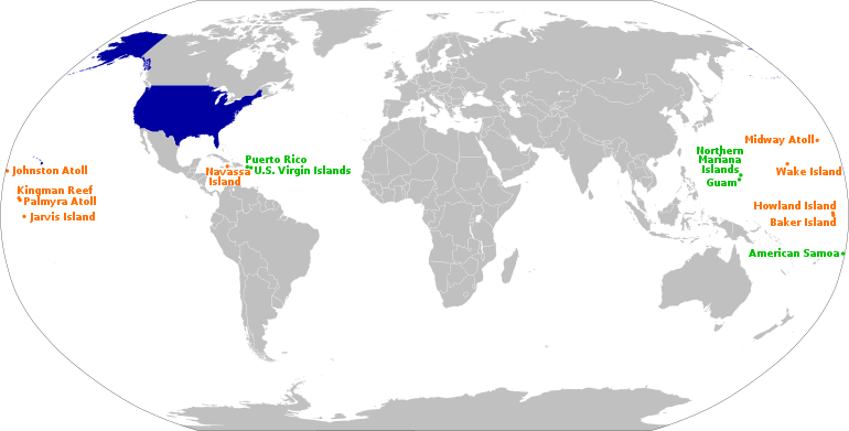
The United States of America is a federal republic[1] consisting of 50 states, a federal district (Washington, D.C., the capital city of the United States), five major territories, and various minor islands.[2][3] The 48 contiguous states and Washington, D.C., are in North America between Canada and Mexico. Alaska is an exclave in the far northwestern part of North America, connected only to Canada, and Hawaii is an archipelago in the mid-Pacific. Territories of the United States are scattered throughout the Pacific Ocean and the Caribbean Sea.
According to the numerous decisions of the United States Supreme Court, the 50 individual states and the United States as a whole are each sovereign jurisdictions.[4] The states are not administrative divisions of the country; the Tenth Amendment to the United States Constitution allows states to exercise all powers of government not delegated to the federal government. These include regulating intrastate commerce, running elections, creating local governments, and ratifying constitutional amendments. Each state has its own constitution, grounded in republican principles, and government, consisting of three branches: executive, legislative, and judicial.[5] All states and their residents are represented in the federal Congress, a bicameral legislature consisting of the Senate and the House of Representatives. Each state is represented by two senators, while representatives are distributed among the states in proportion to the most recent constitutionally mandated decennial census.[6] Additionally, each state is entitled to select a number of electors to vote in the Electoral College, the body that elects the president of the United States, equal to the total of representatives and senators in Congress from that state.[7] Article IV, Section 3, Clause 1 of the Constitution grants to Congress the authority to admit new states into the Union. Since the establishment of the United States in 1776, the number of states has expanded from the original 13 to the current total of 50, and each new state is admitted on an equal footing with the existing states.[8]
As provided by Article I, Section 8 of the Constitution, Congress exercises "exclusive jurisdiction" over the federal district, which is not part of any state. Prior to passage of the 1973 District of Columbia Home Rule Act, which devolved certain Congressional powers to an elected mayor and council, the district did not have an elected local government. Even so, Congress retains the right to review and overturn laws created by the council and intervene in local affairs.[9] As it is not a state, the district does not have representation in the Senate. However, since 1971, its residents have been represented in the House of Representatives by a non-voting delegate.[10] Additionally, since 1961, following ratification of the 23rd Amendment, the district has been entitled to select three electors to vote in the Electoral College.
In addition to the 50 states and federal district, the United States has sovereignty over 14 territories. Five of them (American Samoa, Guam, the Northern Mariana Islands, Puerto Rico, and the U.S. Virgin Islands) have a permanent, nonmilitary population, while nine of them do not. With the exception of Navassa Island, Puerto Rico, and the U.S. Virgin Islands, which are located in the Caribbean, all territories are located in the Pacific Ocean. One territory, Palmyra Atoll, is considered to be incorporated, meaning the full body of the Constitution has been applied to it; the other territories are unincorporated, meaning the Constitution does not fully apply to them. Ten territories (the Minor Outlying Islands and American Samoa) are considered to be unorganized, meaning they have not had an Organic Act enacted by Congress; the four other territories are organized, meaning they have had an Organic Act that has been enacted by Congress. The five inhabited territories each have limited autonomy and a non-voting delegate in Congress, in addition to having territorial legislatures and governors, but residents cannot vote in federal elections.
States
The table below lists the 50 states, with their current capital, largest city,[A] the date they ratified the U.S. Constitution or were admitted to the Union, population and area data, and number of representative(s) in the U.S. House of Representatives.[B]
| Flag, name and postal abbreviation[13] |
Cities | Ratification or admission[C] |
Population [15] |
Total area[16] | Land area[16] | Water area[16] | Number of Reps. | |||||
|---|---|---|---|---|---|---|---|---|---|---|---|---|
| Capital | Largest[17] | mi2 | km2 | mi2 | km2 | mi2 | km2 | |||||
| AL | Montgomery | Huntsville | Dec 14, 1819 | 5,024,279
|
52,420 | 135,767 | 50,645 | 131,171 | 1,775 | 4,597 | 7
| |
| AK | Juneau | Anchorage | Jan 3, 1959 | 733,391
|
665,384 | 1,723,337 | 570,641 | 1,477,953 | 94,743 | 245,384 | 1
| |
| AZ | Phoenix | Feb 14, 1912 | 7,151,502
|
113,990 | 295,234 | 113,594 | 294,207 | 396 | 1,026 | 9
| ||
| AR | Little Rock | Jun 15, 1836 | 3,011,524
|
53,179 | 137,732 | 52,035 | 134,771 | 1,143 | 2,961 | 4
| ||
| CA | Sacramento | Los Angeles | Sep 9, 1850 | 39,538,223
|
163,695 | 423,967 | 155,779 | 403,466 | 7,916 | 20,501 | 53
| |
| CO | Denver | Aug 1, 1876 | 5,773,714
|
104,094 | 269,601 | 103,642 | 268,431 | 452 | 1,170 | 7
| ||
| CT | Hartford | Bridgeport | Jan 9, 1788 | 3,605,944
|
5,543 | 14,357 | 4,842 | 12,542 | 701 | 1,816 | 5
| |
| DE | Dover | Wilmington | Dec 7, 1787 | 989,948
|
2,489 | 6,446 | 1,949 | 5,047 | 540 | 1,399 | 1
| |
| FL | Tallahassee | Jacksonville | Mar 3, 1845 | 21,538,187
|
65,758 | 170,312 | 53,625 | 138,887 | 12,133 | 31,424 | 27
| |
| GA | Atlanta | Jan 2, 1788 | 10,711,908
|
59,425 | 153,910 | 57,513 | 148,959 | 1,912 | 4,951 | 14
| ||
| HI | Honolulu | Aug 21, 1959 | 1,455,271
|
10,932 | 28,313 | 6,423 | 16,635 | 4,509 | 11,678 | 2
| ||
| ID | Boise | Jul 3, 1890 | 1,839,106
|
83,569 | 216,443 | 82,643 | 214,045 | 926 | 2,398 | 2
| ||
| IL | Springfield | Chicago | Dec 3, 1818 | 12,812,508
|
57,914 | 149,995 | 55,519 | 143,793 | 2,395 | 6,202 | 18
| |
| IN | Indianapolis | Dec 11, 1816 | 6,785,528
|
36,420 | 94,326 | 35,826 | 92,789 | 593 | 1,537 | 9
| ||
| IA | Des Moines | Dec 28, 1846 | 3,190,369
|
56,273 | 145,746 | 55,857 | 144,669 | 416 | 1,077 | 4
| ||
| KS | Topeka | Wichita | Jan 29, 1861 | 2,937,880
|
82,278 | 213,100 | 81,759 | 211,754 | 520 | 1,346 | 4
| |
| KY | Frankfort | Louisville | Jun 1, 1792 | 4,505,836
|
40,408 | 104,656 | 39,486 | 102,269 | 921 | 2,387 | 6
| |
| LA | Baton Rouge | New Orleans | Apr 30, 1812 | 4,657,757
|
52,378 | 135,659 | 43,204 | 111,898 | 9,174 | 23,761 | 6
| |
| ME | Augusta | Portland | Mar 15, 1820 | 1,362,359
|
35,380 | 91,633 | 30,843 | 79,883 | 4,537 | 11,750 | 2
| |
| MD | Annapolis | Baltimore | Apr 28, 1788 | 6,177,224
|
12,406 | 32,131 | 9,707 | 25,142 | 2,699 | 6,990 | 8
| |
| MA | Boston | Feb 6, 1788 | 7,029,917
|
10,554 | 27,336 | 7,800 | 20,202 | 2,754 | 7,134 | 9
| ||
| MI | Lansing | Detroit | Jan 26, 1837 | 10,077,331
|
96,714 | 250,487 | 56,539 | 146,435 | 40,175 | 104,052 | 14
| |
| MN | St. Paul | Minneapolis | May 11, 1858 | 5,706,494
|
86,936 | 225,163 | 79,627 | 206,232 | 7,309 | 18,930 | 8
| |
| MS | Jackson | Dec 10, 1817 | 2,961,279
|
48,432 | 125,438 | 46,923 | 121,531 | 1,508 | 3,907 | 4
| ||
| MO | Jefferson City | Kansas City | Aug 10, 1821 | 6,154,913
|
69,707 | 180,540 | 68,742 | 178,040 | 965 | 2,501 | 8
| |
| MT | Helena | Billings | Nov 8, 1889 | 1,084,225
|
147,040 | 380,831 | 145,546 | 376,962 | 1,494 | 3,869 | 1
| |
| NE | Lincoln | Omaha | Mar 1, 1867 | 1,961,504
|
77,348 | 200,330 | 76,824 | 198,974 | 524 | 1,356 | 3
| |
| NV | Carson City | Las Vegas | Oct 31, 1864 | 3,104,614
|
110,572 | 286,380 | 109,781 | 284,332 | 791 | 2,048 | 4
| |
| NH | Concord | Manchester | Jun 21, 1788 | 1,377,529
|
9,349 | 24,214 | 8,953 | 23,187 | 397 | 1,027 | 2
| |
| NJ | Trenton | Newark | Dec 18, 1787 | 9,288,994
|
8,723 | 22,591 | 7,354 | 19,047 | 1,368 | 3,544 | 12
| |
| NM | Santa Fe | Albuquerque | Jan 6, 1912 | 2,117,522
|
121,590 | 314,917 | 121,298 | 314,161 | 292 | 757 | 3
| |
| NY | Albany | New York City | Jul 26, 1788 | 20,201,249
|
54,555 | 141,297 | 47,126 | 122,057 | 7,429 | 19,240 | 27
| |
| NC | Raleigh | Charlotte | Nov 21, 1789 | 10,439,388
|
53,819 | 139,391 | 48,618 | 125,920 | 5,201 | 13,471 | 13
| |
| ND | Bismarck | Fargo | Nov 2, 1889 | 779,094
|
70,698 | 183,108 | 69,001 | 178,711 | 1,698 | 4,397 | 1
| |
| OH | Columbus | Mar 1, 1803 | 11,799,448
|
44,826 | 116,098 | 40,861 | 105,829 | 3,965 | 10,269 | 16
| ||
| OK | Oklahoma City | Nov 16, 1907 | 3,959,353
|
69,899 | 181,037 | 68,595 | 177,660 | 1,304 | 3,377 | 5
| ||
| OR | Salem | Portland | Feb 14, 1859 | 4,237,256
|
98,379 | 254,799 | 95,988 | 248,608 | 2,391 | 6,191 | 5
| |
| PA | Harrisburg | Philadelphia | Dec 12, 1787 | 13,002,700
|
46,054 | 119,280 | 44,743 | 115,883 | 1,312 | 3,397 | 18
| |
| RI | Providence | May 29, 1790 | 1,097,379
|
1,545 | 4,001 | 1,034 | 2,678 | 511 | 1,324 | 2
| ||
| SC | Columbia | Charleston | May 23, 1788 | 5,118,425
|
32,020 | 82,933 | 30,061 | 77,857 | 1,960 | 5,076 | 7
| |
| SD | Pierre | Sioux Falls | Nov 2, 1889 | 886,667
|
77,116 | 199,729 | 75,811 | 196,350 | 1,305 | 3,379 | 1
| |
| TN | Nashville | Jun 1, 1796 | 6,910,840
|
42,144 | 109,153 | 41,235 | 106,798 | 909 | 2,355 | 9
| ||
| TX | Austin | Houston | Dec 29, 1845 | 29,145,505
|
268,596 | 695,662 | 261,232 | 676,587 | 7,365 | 19,075 | 36
| |
| UT | Salt Lake City | Jan 4, 1896 | 3,271,616
|
84,897 | 219,882 | 82,170 | 212,818 | 2,727 | 7,064 | 4
| ||
| VT | Montpelier | Burlington | Mar 4, 1791 | 643,077
|
9,616 | 24,906 | 9,217 | 23,871 | 400 | 1,035 | 1
| |
| VA | Richmond | Virginia Beach | Jun 25, 1788 | 8,631,393
|
42,775 | 110,787 | 39,490 | 102,279 | 3,285 | 8,508 | 11
| |
| WA | Olympia | Seattle | Nov 11, 1889 | 7,705,281
|
71,298 | 184,661 | 66,456 | 172,119 | 4,842 | 12,542 | 10
| |
| WV | Charleston | Jun 20, 1863 | 1,793,716
|
24,230 | 62,756 | 24,038 | 62,259 | 192 | 497 | 3
| ||
| WI | Madison | Milwaukee | May 29, 1848 | 5,893,718
|
65,496 | 169,635 | 54,158 | 140,268 | 11,339 | 29,367 | 8
| |
| WY | Cheyenne | Jul 10, 1890 | 576,851
|
97,813 | 253,335 | 97,093 | 251,470 | 720 | 1,864 | 1
| ||
Federal district
| Name and postal abbreviation[13] |
Established | Population [15] |
Total area[16] | Land area[16] | Water area[16] | Number of Reps. | ||||
|---|---|---|---|---|---|---|---|---|---|---|
| mi2 | km2 | mi2 | km2 | mi2 | km2 | |||||
| DC | Jul 16, 1790[18] | 689,545 | 68 | 176 | 61 | 158 | 7 | 18 | 1[E]
| |
Territories
This list does not include Indian reservations which have limited tribal sovereignty, nor Freely Associated States which participate in some U.S. government programs but are not under U.S. sovereignty.
Inhabited territories
| Name and postal abbreviation[13] |
Capital | Acquired [20] |
Territorial status[21] | Population[15][22] | Total area[16] | Land area[16] | Water area[16] | Number of Reps. | ||||
|---|---|---|---|---|---|---|---|---|---|---|---|---|
| mi2 | km2 | mi2 | km2 | mi2 | km2 | |||||||
| AS | Pago Pago[23] | 1900 | 49,710
|
581 | 1,505 | 76 | 198 | 505 | 1,307 | 1[E]
| ||
| GU | Hagåtña[25] | 1899 | Unincorporated, organized
|
153,836
|
571 | 1,478 | 210 | 543 | 361 | 935 | 1[E]
| |
| MP | Saipan[26] | 1986 | Unincorporated, organized[G]
|
47,329
|
1,976 | 5,117 | 182 | 472 | 1,793 | 4,644 | 1[E]
| |
| PR | San Juan[27] | 1899 | Unincorporated, organized[G]
|
3,285,874
|
5,325 | 13,791 | 3,424 | 8,868 | 1,901 | 4,924 | 1[H]
| |
| VI | Charlotte Amalie[28] | 1917 | Unincorporated, organized
|
87,146
|
733 | 1,898 | 134 | 348 | 599 | 1,550 | 1[E]
| |
Uninhabited territories
| Name | Acquired[20] | Territorial status[21] | Land area[I] | |
|---|---|---|---|---|
| mi2 | km2 | |||
| Baker Island[29] | 1856 | Unincorporated; unorganized
|
0.9 | 2.2 |
| Howland Island[29] | 1858 | Unincorporated, unorganized
|
0.6 | 1.6 |
| Jarvis Island[30] | 1856 | Unincorporated, unorganized
|
2.2 | 5.7 |
| Johnston Atoll[31] | 1859 | Unincorporated, unorganized
|
1 | 2.6 |
| Kingman Reef[32] | 1860 | Unincorporated, unorganized
|
0.005 | 0.01 |
| Midway Atoll[J][34] | 1867 | Unincorporated, unorganized
|
3 | 7.8 |
| Navassa Island[35] | 1858[K] | Unincorporated, unorganized
|
3 | 7.8 |
| Palmyra Atoll[L][37] | 1898 | Incorporated, unorganized
|
1.5 | 3.9 |
| Wake Island[M][38] | 1899[N] | Unincorporated, unorganized
|
2.5 | 6.5 |
Disputed territories
| Name | Claimed [20] |
Territorial status[40] | Area | Administered by[40] | Also claimed by[40] | |
|---|---|---|---|---|---|---|
| mi2 | km2 | |||||
| Bajo Nuevo Bank (Petrel Island)[20] | 1869 | Unincorporated, unorganized
(disputed sovereignty) |
56 | 145[O][41] | ||
| Serranilla Bank[20] | 1880 | Unincorporated, unorganized
(disputed sovereignty) |
463 | 1,200[P][42] | ||
See also
- Local government in the United States
- List of Indian reservations in the United States
- List of regions of the United States
- Historic regions of the United States
- Lists of U.S. state topics
- Proposals for a 51st state
- Aboriginal title in the United States
- Organized incorporated territories of the United States
- Territorial evolution of the United States
- U.S. territorial sovereignty
Explanatory notes
- ^ The largest city is the city in a state with the largest population in the city proper (as opposed to metropolitan area).
- ^ Each state is entitled to at least one representative. Current federal law sets the number of voting members of the House of Representatives at 435, which are apportioned among states every ten years according to their relative population.[11] Each state is also entitled to two senators.[12]
- ^ The original 13 states became sovereign in July 1776 upon agreeing to the United States Declaration of Independence, and each joined the first Union of states between 1777 and 1781, upon ratifying the Articles of Confederation.[14] These states are presented in the order in which each ratified the 1787 Constitution, thus joining the present federal Union of states. Subsequent states are listed in the order of their admission to the Union, and the date given is the official establishment date set by Act of Congress. For further details, see List of U.S. states by date of admission to the Union
- ^ a b c d Uses the term commonwealth rather than state in its full official name
- ^ a b c d e Represented by a non-voting delegate in the House of Representatives.[19]
- ^ Although not organized through a federal organic act or other explicit Congressional directive on governance, the people of American Samoa adopted a constitution in 1967, and then in 1977, elected territorial officials for the first time.[24]
- ^ a b Organized as a commonwealth.
- ^ Represented by a non-voting resident commissioner in the House of Representatives.[19]
- ^ Excluding lagoon
- ^ Although there are no indigenous inhabitants, around 40 United States Fish and Wildlife Service staff and service contractors live on the island at any given time.[33]
- ^ U.S. sovereignty is disputed by Haiti.[36]
- ^ Although there are no indigenous inhabitants, between four and 20 Nature Conservancy, employees, United States Fish and Wildlife Service staff, and researchers live on the island at any given time.[33]
- ^ Although there are no indigenous inhabitants, as of 2009, around 150 U.S. 150 U.S. military personnel and civilian contractors were living on the island, staffing the Wake Island Airfield and communications facilities.[38]
- ^ U.S. sovereignty is disputed by the Republic of Marshall Islands.[39]
- ^ This is the approximate figure for the land area of the bank, and does not include the surrounding territorial waters.
- ^ This figure includes the total land area of the Serranilla Bank and the water area of its lagoon, but not the surrounding territorial waters.
References
- ^ Onuf, Peter S. (1983). The Origins of the Federal Republic: Jurisdictional Controversies in the United States, 1775–1787. Philadelphia: University of Pennsylvania Press. ISBN 978-0-8122-1167-2.
- ^ "Common Core Document of the United States of America: Submitted With the Fourth Periodic Report of the United States of America to the United Nations Committee on Human Rights concerning the International Covenant on Civil and Political Rights". U.S. Department of State, via The Office of Website Management, Bureau of Public Affairs. Retrieved July 9, 2017.
- ^ "U.S. Insular Areas: application of the U.S. Constitution" (PDF). Government Accountability Office. November 1997. Archived (PDF) from the original on November 3, 2013. Retrieved July 10, 2013.
- ^ Radan, 2007, p. 12
- ^ "Frequently Asked Questions About the Minnesota Legislature". Minnesota State Legislature. Archived from the original on October 21, 2013. Retrieved July 11, 2013.
- ^ Burnett, Kristin D. "Congressional Apportionment (2010 Census Briefs C2010BR-08)" (PDF). U.S. Department of Commerce, Economics and Statistics Administration. Archived from the original (PDF) on November 19, 2011.
- ^ Elhauge, Einer R. "Essays on Article II: Presidential Electors". The Heritage Foundation. Archived from the original on July 24, 2017. Retrieved December 29, 2015.
- ^ "Doctrine of the Equality of States". Justia Law. Archived from the original on October 19, 2012. Retrieved June 16, 2017.
- ^ "DC Home Rule". Council of the District of Columbia. Archived from the original on November 17, 2011.
- ^ Tarr, David R.; Benenson, Bob, eds. (2012). Elections A to Z (4th ed.). Sage Publications. p. 165. ISBN 9780872897694. Archived from the original on May 27, 2016. Retrieved December 29, 2015.
- ^ "The Permanent Apportionment Act of 1929: June 11, 1929". Washington, D.C.: Office of the Historian, United States House of Representatives. Archived from the original on January 30, 2018. Retrieved February 28, 2018.
- ^ "The Senate and the United States Constitution". www.senate.gov. Washington, D.C.: Secretary of the Senate. Archived from the original on January 19, 2018. Retrieved February 28, 2018.
- ^ a b c "Appendix B: Two–Letter State and possession Abbreviations". Postal Addressing Standards. Washington, D.C.: United States Postal Service. May 2015. Archived from the original on March 5, 2018. Retrieved March 3, 2018.
- ^ Jensen, Merrill (1959). The Articles of Confederation: An Interpretation of the Social-Constitutional History of the American Revolution, 1774–1781. University of Wisconsin Press. pp. xi, 184. ISBN 978-0-299-00204-6.
- ^ a b c "RESIDENT POPULATION FOR THE 50 STATES, THE DISTRICT OF COLUMBIA, AND PUERTO RICO: 2020 CENSUS" (PDF). U.S. Census Bureau.
{{cite web}}: CS1 maint: url-status (link) - ^ a b c d e f g h i "State Area Measurements and Internal Point Coordinates". Washington, D.C.: U.S. Census Bureau. Archived from the original on March 16, 2018. Retrieved March 3, 2018.
... provides land, water and total area measurements for the 50 states, the District of Columbia, Puerto Rico and the Island Areas. The area measurements were derived from the Census Bureau's Master Address File/Topologically Integrated Geographic Encoding and Referencing (MAF/TIGER) database. The land and water areas, ... reflect base feature updates made in the MAF/TIGER database through August, 2010.
- ^ "State and Local Government Finances and Employment" (PDF). United States Census Bureau. 2012. p. 284. Archived from the original (PDF) on October 17, 2011. Retrieved July 8, 2013.
- ^ "The History of Washington, DC". Destination DC. March 15, 2016. Archived from the original on March 6, 2018. Retrieved March 3, 2018.
- ^ a b "Directory of Representatives". Washington, D.C.: U.S. House of Representatives. Archived from the original on March 5, 2018. Retrieved March 5, 2018.
- ^ a b c d e "Acquisition Process of Insular Areas". Office of Insular Affairs. Archived from the original on April 14, 2012. Retrieved July 9, 2013.
{{cite web}}: CS1 maint: unfit URL (link) - ^ a b "Definitions of Insular Area Political Organizations". Washington, D.C.: U.S. Department of the Interior. June 12, 2015. Archived from the original on July 13, 2018. Retrieved March 1, 2018.
- ^ 2020 Population of U.S. Island Areas Just Under 339,000, U.S. Census Bureau, October 28, 2021.
- ^ "American Samoa". The World Factbook. Central Intelligence Agency. Retrieved July 9, 2013.
- ^ "Islands We Serve: American Samoa". Washington, D.C.: U.S. Department of the Interior. June 11, 2015. Archived from the original on March 9, 2018. Retrieved March 1, 2018.
- ^ "Guam". The World Factbook. Central Intelligence Agency. Retrieved July 9, 2013.
- ^ "Northern Mariana Islands". The World Factbook. Central Intelligence Agency. Retrieved July 9, 2013.
- ^ "Puerto Rico". The World Factbook. Central Intelligence Agency. Retrieved July 9, 2013.
- ^ "Virgin Islands". The World Factbook. Retrieved July 9, 2013.
- ^ a b "Baker Island". Office of Insular Affairs. Archived from the original on April 19, 2012. Retrieved July 9, 2013.
- ^ "Jarvis Island". Office of Insular Affairs. Archived from the original on February 7, 2012. Retrieved July 9, 2013.
- ^ "Johnston Island". Office of Insular Affairs. Archived from the original on March 14, 2012. Retrieved July 9, 2013.
- ^ "Kingman Reef National Wildlife Refuge". United States Fish and Wildlife Service. Archived from the original on May 16, 2013. Retrieved July 9, 2013.
- ^ a b "United States Pacific Islands Wildlife Refuges". The World Factbook. Central Intelligence Agency. Retrieved October 10, 2014.
- ^ "Midway Atoll". Office of Insular Affairs. Archived from the original on February 4, 2012. Retrieved July 9, 2013.
- ^ "Navassa Island". Washington, D.C.: U.S. Department of the Interior. June 12, 2015. Archived from the original on August 15, 2016. Retrieved March 3, 2018.
- ^ "Palmyra Atoll". Office of Insular Affairs. Archived from the original on January 11, 2012. Retrieved July 9, 2013.
- ^ a b "Wake Island". The World Factbook. Central Intelligence Agency. Retrieved October 10, 2014.
- ^ Earnshaw, Karen (December 17, 2016). "Enen Kio (a.k.a. Wake Island): Island of the kio flower". Marshall Islands Guide. Majuro, Republic of the Marshall Islands. Archived from the original on April 1, 2018. Retrieved March 4, 2018.
- ^ a b c Lewis, Martin W. (March 21, 2011). "When Is an Island Not An Island? Caribbean Maritime Disputes". GeoCurrents. Archived from the original on April 22, 2017. Retrieved June 16, 2017.
- ^ "US Minor Outlying Islands – Bajo Nuevo Bank". Geocaching. June 6, 2017. Archived from the original on July 11, 2015. Retrieved July 10, 2015.
- ^ "Cayo Serranilla" (in Spanish). Eco Fiwi. Archived from the original on July 31, 2017. Retrieved June 16, 2017.
- Radan, Peter (2007). Creating New States: Theory and Practice of Secession. Ashgate Publishing, Ltd. ISBN 9780754671633.
External links
| Wikimedia Commons has media related to States of the United States. |
| States |
|
|---|---|
| Federal district | Washington, D.C. |
| Insular areas |
|
| Outlying islands |
|
| Indian reservations | |
| Others | |
| Demographics |
|
|---|---|
| Economy |
|
| Environment |
|
| Geography |
|
| Government |
|
| Health |
|
| History |
|
| Law |
|
| Miscellaneous |
|
| |
Administrative divisions of the Americas | ||
|---|---|---|
| ||
| Sovereign states |
|  |
Dependencies and other territories | ||
- Administrative divisions of the United States by state
- Political divisions of the United States
- Administrative divisions in North America
- Lists of administrative divisions
- States of the United States
- Lists of subdivisions of the United States
- United States geography-related lists
- Lists of states of the United States