Island
Region
Alternate name
Coordinates
Current status
Resolution of U.S. claim[1]
Alto Velo Island
Caribbean
Alta Vela Island; Isla Alto Velo
17°28′42″N 71°38′05″W / 17.47833°N 71.63472°W / 17.47833; -71.63472 (Alto Velo Island ) Dominican Republic Rejected. See Alto Velo Claim .
Atafu
Oceania
Duke of York Group
8°33′06″S 172°30′03″W / 8.55167°S 172.50083°W / -8.55167; -172.50083 (Atafu ) Tokelau
Treaty of Tokehega
Bajo Nuevo Bank
Caribbean
Petrel Islands
15°53′N 78°38′W / 15.883°N 78.633°W / 15.883; -78.633 (Bajo Nuevo Bank ) Disputed
Remains in place as an unincorporated territory .Colombia , and also claimed by Jamaica and Nicaragua .
Baker Island
Oceania
New Nantucket
0°11′41″N 176°28′46″W / 0.19472°N 176.47944°W / 0.19472; -176.47944 (Baker Island ) US Minor Islands
Unincorporated territory
Birnie Island
Oceania
3°35′S 171°33′W / 3.583°S 171.550°W / -3.583; -171.550 (Birnie Island ) Kiribati
Treaty of Tarawa
Butaritari
Oceania
Makin Atoll, Makin Island, Touching Island
3°10′04″N 172°49′33″E / 3.16778°N 172.82583°E / 3.16778; 172.82583 (Butaritari ) Kiribati
Treaty of Tarawa
Caroline Island
Oceania
Millennium Island
9°56′13″S 150°12′42″W / 9.93694°S 150.21167°W / -9.93694; -150.21167 (Caroline Island ) Kiribati
Treaty of Tarawa
Carondelet Reef
Oceania
5°34′S 173°51′W / 5.567°S 173.850°W / -5.567; -173.850 (Carondelet Reef ) Kiribati
Treaty of Tarawa
Clipperton Island
Pacific Ocean
Passion Island
10°18′N 109°13′W / 10.300°N 109.217°W / 10.300; -109.217 (Clipperton Island ) France
Original treaty between Mexico and France. Also claimed by Mexico .
Ducie Island
Oceania
24°40′09″S 124°47′11″W / 24.66917°S 124.78639°W / -24.66917; -124.78639 (Ducie Island ) British Territory
Dormant. Administered by Pitcairn Islands .
Enderbury Island
Oceania
Guano Island
3°08′S 171°05′W / 3.133°S 171.083°W / -3.133; -171.083 (Enderbury Island ) Kiribati
Treaty of Tarawa
Fakaofo
Oceania
Bowditch Island
9°21′55″S 171°12′54″W / 9.36528°S 171.21500°W / -9.36528; -171.21500 (Fakaofo ) Tokelau
Treaty of Tokehega
Flint Island
Oceania
11°25′48″S 151°49′9″W / 11.43000°S 151.81917°W / -11.43000; -151.81917 (Flint Island ) Kiribati
Treaty of Tarawa
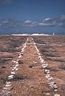
French Frigate Shoals Oceania
Kānemilohaʻi
23°44′56″N 166°8′46″W / 23.74889°N 166.14611°W / 23.74889; -166.14611 (French Frigate Shoals ) Hawaii
Assumed sole competing claim through annexation of Hawaii State of Hawaii (1959).
Funafuti
Oceania
8°31′S 179°13′E / 8.517°S 179.217°E / -8.517; 179.217 (Funafuti ) Tuvalu
Tuvalu -US Treaty of 1983
Howland Island
Oceania
Worth Island
0°48′07″N 176°38′3″W / 0.80194°N 176.63417°W / 0.80194; -176.63417 (Howland Island ) US Minor Islands
Unincorporated territory
Isla de Aves
Caribbean
Isla de Aves
15°40′18″N 63°36′59″W / 15.67167°N 63.61639°W / 15.67167; -63.61639 (Isla Aves ) Venezuela
United States–Venezuela Maritime Boundary Treaty
Îles du Connétable
Atlantic Ocean
Constable Islands
4°49′25″N 51°56′11″W / 4.82361°N 51.93639°W / 4.82361; -51.93639 (Iles du Connétable ) France
Rescinded. Administered by French Guiana .
Jarvis Island
Oceania
Bunker Island
0°22′S 160°01′W / 0.367°S 160.017°W / -0.367; -160.017 (Jarvis Island ) US Minor Islands
Unincorporated territory
Johnston Atoll
Oceania
16°44′13″N 169°31′26″W / 16.73694°N 169.52389°W / 16.73694; -169.52389 (Johnston Atoll ) US Minor Islands
Unincorporated territory
Kanton Island
Oceania
Canton Island
2°50′S 171°40′W / 2.833°S 171.667°W / -2.833; -171.667 (Kanton Island ) Kiribati
Treaty of Tarawa
Kingman Reef
Oceania
Danger Rock
6°24′N 162°24′W / 6.400°N 162.400°W / 6.400; -162.400 (Kingman Reef ) US Minor Islands
Unincorporated territory
Kiritimati
Oceania
Christmas Island
1°52′N 157°24′W / 1.867°N 157.400°W / 1.867; -157.400 (Kiritimati ) Kiribati
Treaty of Tarawa
Lacepede Islands
Oceania
Lacapade [sic
16°51′55″S 122°08′12″E / 16.86528°S 122.13667°E / -16.86528; 122.13667 (Lacepede Islands ) Australia
Claim made on 26 June 1876; repudiated by US government in 1877.
Makin (atoll)
Oceania
Little Makin
3°23′00″N 173°00′00″E / 3.38333°N 173.00000°E / 3.38333; 173.00000 (Makin (islands) ) Kiribati
Treaty of Tarawa
Malden Island
Oceania
Independence Island
4°01′S 154°56′W / 4.017°S 154.933°W / -4.017; -154.933 (Malden Island ) Kiribati
Treaty of Tarawa
Manihiki
Oceania
Island of Pearls
10°24′S 161°00′W / 10.400°S 161.000°W / -10.400; -161.000 (Manihiki ) Cook Islands
Cook Islands–United States Maritime Boundary Treaty
Manra
Oceania
Sydney Island
4°27′S 171°16′W / 4.450°S 171.267°W / -4.450; -171.267 (Manra Island ) Kiribati
Treaty of Tarawa
McKean Island
Oceania
Wigram Island
3°35′S 174°02′W / 3.583°S 174.033°W / -3.583; -174.033 (McKean Island ) Kiribati
Treaty of Tarawa
Midway Atoll
Oceania
Middlebrook Islands
28°12′N 177°21′W / 28.200°N 177.350°W / 28.200; -177.350 (Midway Atoll ) US Minor Islands
Unincorporated territory
Minami-Tori-shima
Oceania
Marcus Island
24°18′N 153°58′E / 24.300°N 153.967°E / 24.300; 153.967 (Minami Torishima ) Japan
Returned to Japan in 1968 after it had been given to US by Treaty of San Francisco
Navassa Island
Caribbean
Navaza
18°24′10″N 75°0′45″W / 18.40278°N 75.01250°W / 18.40278; -75.01250 (Navassa Island ) US Minor Islands
Unincorporated territory . Also claimed by Haiti .
Nikumaroro
Oceania
Gardner Island
4°40′S 174°31′W / 4.667°S 174.517°W / -4.667; -174.517 (Nikumaroro ) Kiribati
Treaty of Tarawa
Niulakita
Oceania
Sophia Island
10°45′S 179°30′E / 10.750°S 179.500°E / -10.750; 179.500 (Niulakita ) Tuvalu
Tuvalu -US Treaty of 1983
Nukufetau
Oceania
8°00′S 178°30′E / 8.000°S 178.500°E / -8.000; 178.500 (Nukufetau ) Tuvalu
Tuvalu -US Treaty of 1983
Nukulaelae
Oceania
9°22′52″S 179°51′08″E / 9.38111°S 179.85222°E / -9.38111; 179.85222 (Nukulaelae ) Tuvalu
Tuvalu -US Treaty of 1983
Nukunonu
Oceania
Duke of Clarence Island
9°10′06″S 171°48′35″W / 9.16833°S 171.80972°W / -9.16833; -171.80972 (Nukunonu ) Tokelau
Treaty of Tokehega
Orona
Oceania
Hull Island
4°30′S 172°10′W / 4.500°S 172.167°W / -4.500; -172.167 (Orona ) Kiribati
Treaty of Tarawa
Palmyra Atoll
Oceania
5°53′N 162°5′W / 5.883°N 162.083°W / 5.883; -162.083 (Palmyra Atoll ) US Minor Islands
Incorporated territory .[2] annexation of Hawaii (1898), but not included in State of Hawaii (1959).
Penrhyn Island
Oceania
Tongareva
9°00′20″S 157°58′10″W / 9.00556°S 157.96944°W / -9.00556; -157.96944 (Penrhyn Island ) Cook Islands
Cook Islands–United States Maritime Boundary Treaty
Pukapuka
Oceania
San Bernardo Island
10°53′S 165°40′W / 10.883°S 165.667°W / -10.883; -165.667 (Pukapuka ) Cook Islands
Cook Islands–United States Maritime Boundary Treaty
Quita Sueño Bank
Caribbean
Quitasueño
14°19′N 81°10′W / 14.317°N 81.167°W / 14.317; -81.167 (Quita Sueño Bank ) Colombia
Vasquez-Saccio Treaty of 1981
Rakahanga
Oceania
Grand Duke Alexander Island
10°02′S 161°05′W / 10.033°S 161.083°W / -10.033; -161.083 (Rakahanga ) Cook Islands
Cook Islands–United States Maritime Boundary Treaty
Rawaki Island
Oceania
Phoenix Island
3°42′40″S 170°42′43″W / 3.71111°S 170.71194°W / -3.71111; -170.71194 (Rawaki Island ) Kiribati
Treaty of Tarawa
Roncador Bank
Caribbean
13°34′N 80°05′W / 13.567°N 80.083°W / 13.567; -80.083 (Roncador Bank ) Colombia
Vasquez-Saccio Treaty of 1981
Rosalind Bank
Caribbean
Rosa Linda Bank
16°26′N 80°31′W / 16.433°N 80.517°W / 16.433; -80.517 (Rosalind Bank ) Disputed
Multiple nations claim this submerged bank as a part of their EEZs .Colombia -US Vasquez-Saccio Treaty of 1981 is silent on the matter.Colombia , and claimed by Nicaragua , Honduras , the United States , and Jamaica .
Scorpion Reef
Gulf of Mexico
Arrecife Alacranes (Isla Pérez , Isla Chica, Isla Pájaros)
22°24′N 89°42′W / 22.400°N 89.700°W / 22.400; -89.700 (Scorpion Reef ) Mexico
Abandoned claim in 1894[3]
Serrana Bank
Caribbean
14°20′N 80°20′W / 14.333°N 80.333°W / 14.333; -80.333 (Serrana Bank ) Colombia
Vasquez-Saccio Treaty of 1981
Serranilla Bank
Caribbean
15°50′N 79°50′W / 15.833°N 79.833°W / 15.833; -79.833 (Serranilla Bank ) Disputed
Remains in place as an unincorporated territory . Colombia and Jamaica agreed to a condominium of Serranilla's exclusive economic zone; Nicaragua also lays claim.
Starbuck Island
Oceania
Volunteer Island
5°37′S 155°56′W / 5.617°S 155.933°W / -5.617; -155.933 (Starbuck Island ) Kiribati
Treaty of Tarawa
Swains Island [4] Oceania
Olohega, Olosega, Quirós, Isla de la Gente Hermosa, Jennings Island
11°03′20″S 171°04′40″W / 11.05556°S 171.07778°W / -11.05556; -171.07778 (Swains Island ) American Samoa
Treaty of Tokehega
Swan Islands
Caribbean
Islas Santanilla
17°24′38″N 83°55′19″W / 17.41056°N 83.92194°W / 17.41056; -83.92194 (Swan Islands ) Honduras
Honduras -US Treaty of 1972
Tabuaeran
Oceania
Fanning Island
3°51′36″N 159°21′52″W / 3.86000°N 159.36444°W / 3.86000; -159.36444 (Tabuaeran ) Kiribati
Treaty of Tarawa
Teraina
Oceania
Washington Island
4°41′00″N 160°22′40″W / 4.68333°N 160.37778°W / 4.68333; -160.37778 (Teraina ) Kiribati
Treaty of Tarawa
Vostok Island
Oceania
Staver Island
10°06′S 152°23′W / 10.100°S 152.383°W / -10.100; -152.383 (Vostok Island ) Kiribati
Treaty of Tarawa
Winslow Reef
Oceania
1°36′S 174°57′W / 1.600°S 174.950°W / -1.600; -174.950 (Winslow Reef ) Kiribati
Treaty of Tarawa