Districts and sub-districts of the United States Virgin Islands
| Districts of the U.S. Virgin Islands | |
|---|---|
 | |
| Category | County equivalent |
| Location | United States Virgin Islands |
| Number | 2 (administrative districts) 3 (census districts) |
| Populations | 3,881 (Saint John) – 42,461 (Saint Thomas (census districts) |
| Areas | 19.69 sq mi (51.0 km2) (Saint John) – 83.32 sq mi (215.8 km2) (Saint Croix) (census districts) |
| Government | |
| Subdivisions | |
 |
|---|
|
The territorial government of the United States Virgin Islands has for operational purposes established two districts, which include the minor islets nearest to the major islands:[1][2][3]
The U.S. Virgin Islands legislature has 15 seats: 7 seats are for the Saint Croix District, 7 seats are for the Saint Thomas and Saint John District, and one seat is for someone who must live in Saint John.[2]
The U.S. Virgin Islands have no municipalities; the only government is for the territory as a whole.[4]
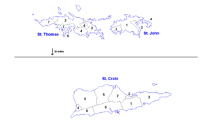
The territory has historically been divided into quarters (which are not one-fourth of anything) and estates. These were used for census purposes until 1980, and estates are commonly used for navigation, writing addresses, and discussing real estate.[4] The U.S. Census uses three districts (Saint Thomas, Saint John, and Saint Croix) as county equivalents.[5][6][7]
In more recent census decades, quarters and estates have been replaced by 20 census subdistricts, which were defined by the territorial government as more meaningful given the terrain and current population distribution. These are used as minor civil divisions.[4]
| Map | Division | Population[8] | Land area[9][10] | ||
|---|---|---|---|---|---|
| # | 2020 | 2010 | sq mi | km2 | |
| Saint Croix | 41,004 | 50,601 | 83.32 | 215.80 | |
| 1 | Anna's Hope Village | 3,282 | 4,041 | 9.89 | 25.61 |
| 2 | Christiansted | 1,866 | 2,626 | 0.76 | 1.97 |
| Christiansted town | 1,770 | 2,433 | 0.51 | 1.32 | |
| 3 | East End | 2,336 | 2,453 | 12.91 | 33.44 |
| 4 | Frederiksted | 2,303 | 3,091 | 1.38 | 3.57 |
| Frederiksted town | 528 | 859 | 0.17 | 0.44 | |
| 5 | Northcentral | 4,197 | 4,977 | 12.66 | 32.79 |
| 6 | Northwest | 3,431 | 4,863 | 18.19 | 47.11 |
| 7 | Sion Farm | 10,332 | 13,003 | 9.40 | 24.35 |
| 8 | Southcentral | 7,415 | 8,049 | 12.62 | 32.69 |
| 9 | Southwest | 5,842 | 7,498 | 5.51 | 14.27 |
| Saint Thomas | 42,261 | 51,634 | 31.31 | 81.09 | |
| 1 | Charlotte Amalie | 14,477 | 18,481 | 3.36 | 8.70 |
| Charlotte Amalie town | 8,194 | 10,354 | 1.21 | 3.13 | |
| 2 | East End | 7,502 | 8,403 | 5.26 | 13.62 |
| 3 | Northside | 8,889 | 10,049 | 10.59 | 27.43 |
| 4 | Southside | 4,112 | 5,411 | 4.42 | 11.45 |
| 5 | Tutu | 5,129 | 6,867 | 1.52 | 3.94 |
| 6 | Water Island | 164 | 182 | 0.97 | 2.51 |
| 7 | West End | 1,988 | 2,241 | 5.19 | 13.44 |
| Saint John | 3,881 | 4,170 | 19.69 | 51.00 | |
| 1 | Central | 470 | 779 | 14.09 | 36.49 |
| 2 | Coral Bay | 724 | 634 | 1.91 | 4.95 |
| 3 | Cruz Bay | 2,652 | 2,706 | 2.77 | 7.17 |
| 4 | East End | 35 | 51 | 0.92 | 2.38 |
| U.S. Virgin Islands | 87,146 | 106,405 | 134.32 | 347.89 | |
See also[]
- List of settlements in the United States Virgin Islands
- Islands of U.S. Virgin Islands
- Minor islands of the United States Virgin Islands
References[]
- ^ http://www.legvi.org/senators/st-thomasst-john/senator-marvin-a-blyden/ Archived October 12, 2018, at the Wayback Machine legvi.org. Senator Marvin A. Blyden. Retrieved July 7, 2018.
- ^ a b http://www.legvi.org/history/ Archived October 12, 2018, at the Wayback Machine Legvi.org. History. Retrieved July 7, 2018.
- ^ https://www.usgs.gov/faqs/how-many-counties-are-there-united-states USGS. How many counties are there in the United States? Retrieved July 7, 2018.
- ^ a b c United States Census (1990). "Puerto Rico and the Outlying Areas" (PDF). Retrieved July 20, 2021.
- ^ https://www.census.gov/geo/reference/codes/cou.html 2010 FIPS Codes for Counties and County Equivalent Entities. Census.gov. Retrieved July 7, 2018.
- ^ https://www2.census.gov/geo/pdfs/reference/GARM/Ch4GARM.pdf States, Counties, and Statistically Equivalent Entities (Chapter 4). Census.gov. Retrieved July 7, 2018.
- ^ http://www.statoids.com/uvi.html Districts of the United States Virgin Islands. Statoids.com. Retrieved July 7, 2018.
- ^ Population of the United States Virgin Islands: 2010 and 2020, U.S. Census Bureau.
- ^ Population, Housing Units, Land Area, and Density by Island and Census Subdistrict for the U.S. Virgin Islands: 2010, U.S. Census Bureau.
- ^ Population, Housing Units, Land Area, and Density by Place for the U.S. Virgin Islands: 2010, U.S. Census Bureau.
External links[]
- Districts of the United States Virgin Islands, United States Census Bureau
- Quarters and estates of Saint Croix
- Quarters and estates of Saint John
Charlotte Amalie (capital) | |
| Topics |
|
| Government | |
| Cities | |
| Islands |
|
| Parks | |
Administrative divisions of the Americas | ||
|---|---|---|
| ||
| Sovereign states |
|  |
- Geography of the United States Virgin Islands
- Lists of administrative divisions
- Administrative divisions in North America
- Sub-districts of the United States Virgin Islands
- Lists of villages in the United States