Cauto River
| Cauto River | |
|---|---|
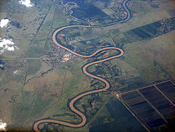 Rio Cauto near Guamo Embarcadero | |
 | |
 Location of mouth | |
| Location | |
| Country | |
| Physical characteristics | |
| Source | |
| • location | Sierra Maestra |
| • elevation | 600 m (1,969 ft) |
| Mouth | Caribbean Sea |
• location | Gulf of Guacanayabo |
• coordinates | 20°32′57″N 77°14′30″W / 20.54917°N 77.24167°WCoordinates: 20°32′57″N 77°14′30″W / 20.54917°N 77.24167°W |
• elevation | Sea level |
| Length | 230 mi (370 km) |
| Basin size | 8,928 km2 (3,447 sq mi) |

The Cauto River or Río Cauto is the longest river in Cuba, as well as the longest river in the Caribbean.[1] Located in southeast Cuba, it is one of two navigable rivers in Cuba, with the other being the Sagua la Grande River.
Overview[]
It flows on a total length of 371 km (231 mi) from the Sierra Maestra to the west and north-west, and enters the Caribbean Sea north of Manzanillo. However, it provides only 110 km (70 mi) of transport waterway. A 2013 study led by multiple Cuban academic institutions determined that the river could be 'classified as unpolluted to moderately polluted'.[2]
It flows through the provinces of Santiago de Cuba, Holguin, and Granma. The communities of Palma Soriano, Cauto Cristo, and Rio Cauto are located along the river. Rice, sugarcane, tobacco, and cattle are the primary agricultural beneficiaries along its course.
Gallery[]
- Cauto River


References[]
- ^ "Caribbean Geography". World Atlas. Retrieved 2021-06-09.
- ^ "Contamination assessment of heavy metal in surface sediments of the Cauto River (Cuba)". Proceedings of XIV Workshop on Nuclear Physics VIII International Symposium on Nuclear and Related Techniques WONP-NURT 2013 – via INIS.
External links[]
![]() Media related to Río Cauto (river) at Wikimedia Commons
Media related to Río Cauto (river) at Wikimedia Commons
| Authority control |
|
|---|
- Rivers of Cuba
- Geography of Granma Province
- Geography of Santiago de Cuba Province
- North America river stubs
- Cuba geography stubs