Cave of Altamira and Paleolithic Cave Art of Northern Spain
This article includes a list of references, related reading or external links, but its sources remain unclear because it lacks inline citations. (November 2018) |
| UNESCO World Heritage Site | |
|---|---|
 Replica of the Cave of Altamira at the National Archaeological Museum (Madrid) | |
| Location | Northern Spain |
| Includes |
|
| Criteria | Cultural: (i), (iii) |
| Reference | 310bis |
| Inscription | 1985 (9th Session) |
| Extensions | 2008 |
| Buffer zone | 2,234.706 ha (5,522.08 acres) |
| Coordinates | 43°22′39″N 4°07′21″W / 43.3774°N 4.1225°WCoordinates: 43°22′39″N 4°07′21″W / 43.3774°N 4.1225°W |
 Location of Cave of Altamira and Paleolithic Cave Art of Northern Spain in Earth | |


The Cave of Altamira and Paleolithic Cave Art of Northern Spain (Cueva de Altamira y arte rupestre paleolítico del Norte de España) is a grouping of 18 caves of northern Spain, which together represent the apogee of Upper Paleolithic cave art in Europe between 35,000 and 11,000 years ago (Aurignacian, Gravettian, Solutrean, Magdalenian, Azilian). In 2008, they were collectively designated a World Heritage Site by UNESCO.
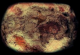
Chief among these caves is Altamira, located within the town of Santillana del Mar in Cantabria. It remains one of the most important painting cycles of prehistory, originating in the Magdalenian and Solutrean periods of the Upper Paleolithic. This cave's artistic style represents the Franco-cantabrian school, characterized by the realism of its figural representation. Altamira Cave was declared a World Heritage Site in 1985. In 2008, the World Heritage Site was expanded to include 17 additional caves located in three autonomous communities of northern Spain: Asturias, Cantabria and the Basque Country.
List of caves[]
| Code | Name | Location | Coordinates | Buffer zone | |
|---|---|---|---|---|---|
| 310-001 | Cueva de Altamira | 43°22′57″N 04°07′13″W / 43.38250°N 4.12028°W | 16 ha | 
| |
| 310-002 | 43°27′21″N 6°4′21″W / 43.45583°N 6.07250°W | 100 ha | 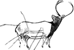
| ||
| 310-003 | Cueva de Tito Bustillo | 43°27′39″N 5°4′4″W / 43.46083°N 5.06778°W | 243 ha | 
| |
| 310-004 | 43°19′5″N 4°52′30″W / 43.31806°N 4.87500°W | 11.3 ha | 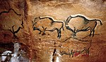
| ||
| 310-005 | 43°19′50″N 4°38′43″W / 43.33056°N 4.64528°W | 17.4 ha | 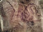
| ||
| 310-006 | 43°23′51″N 4°31′58″W / 43.39750°N 4.53278°W | 69.4 ha | 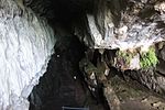
| ||
| 310-007 | Cueva de Chufín | 43°17′26″N 4°27′29″W / 43.29056°N 4.45806°W | 16.7 ha | ||
| 310-008 | 43°15′40″N 4°1′47″W / 43.26111°N 4.02972°W | 25 ha | 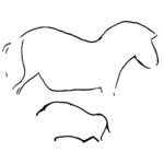
| ||
| 310-009 | Cueva de El Castillo | 43°17′33″N 3��57′56″W / 43.2924°N 3.9655°W | 69 ha | 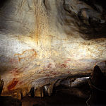
| |
| 310-010 | Cueva de Las Monedas | 43°17′20″N 3°58′03″W / 43.289°N 3.9675°W | 69 ha | 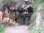
| |
| 310-011 | Cueva de La Pasiega | 43°17′20″N 3°57′58″W / 43.289°N 3.966°W | 69 ha | 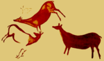
| |
| 310-012 | Cueva de Las Chimeneas | 43°17′29″N 3°57′52″W / 43.2914°N 3.9644°W | 69 ha | 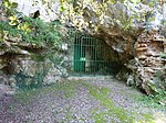
| |
| 310-013 | 43°23′17″N 3°54′44″W / 43.38806°N 3.91222°W | 64 ha | |||
| 310-014 | Cueva de La Garma | 43°25′50″N 3°39′57″W / 43.43056°N 3.66583°W | 100 ha | 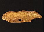
| |
| 310-015 | 43°14′44″N 3°27′08″W / 43.24556°N 3.45222°W | 1374 ha | 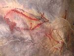
| ||
| 310-016 | Cueva de Santimamiñe | 43°20′47″N 2°38′12″W / 43.34639°N 2.63667°W | 99 ha | 
| |
| 310-017 | 43°14′09″N 02°16′31″W / 43.23583°N 2.27528°W | 14.6 ha | 
| ||
| 310-018 | Cueva de Altxerri | 43°16′7″N 02°08′02″W / 43.26861°N 2.13389°W | 15 ha | 
|
See also[]
| Wikimedia Commons has media related to Cave of Altamira and Paleolithic Cave Art of Northern Spain. |
- National Museum and Research Center of Altamira
- Caves in Cantabria
- Franco-Cantabrian region
- Art of the Upper Paleolithic
- List of Stone Age art
References[]
- Cave of Altamira and Paleolithic Cave Art of Northern Spain (unesco.org)
- Pike, A. W. G.; Hoffmann, D. L.; Garcia-Diez, M.; Pettitt, P. B.; Alcolea, J.; De Balbin, R.; Gonzalez-Sainz, C.; de las Heras, C.; Lasheras, J. A.; Montes, R.; Zilhao, J. (14 June 2012). "U-Series Dating of Paleolithic Art in 11 Caves in Spain". Science. 336 (6087): 1409–1413. Bibcode:2012Sci...336.1409P. doi:10.1126/science.1219957. PMID 22700921. S2CID 7807664.
World Heritage Sites in Spain | ||
|---|---|---|
For official site names, see each article or the List of World Heritage Sites in Spain. | ||
| North West |
| |
| North East |
| |
| Centre |
| |
| East |
| |
| South |
| |
| Balearic Islands |
| |
| Canary Islands |
| |
| ||
- Art of the Upper Paleolithic
- Paleolithic Europe
- Rock art in Spain
- Limestone caves
- Show caves in Spain
- Green Spain
- Prehistoric sites in Spain
- World Heritage Sites in Spain
- Landforms of the Basque Country (autonomous community)
- Landforms of Asturias
- Tourist attractions in Asturias
- Protected areas of Asturias
- Tourist attractions in the Basque Country (autonomous community)
- Caves of Cantabria