Cawood Bridge
Cawood Bridge | |
|---|---|
 | |
| Coordinates | 53°50′02″N 1°07′41″W / 53.833778°N 1.128094°W |
| Crosses | River Ouse |
| Locale | Cawood, North Yorkshire |
| Heritage status | Grade II listed |
| Characteristics | |
| Design | Swing bridge |
| History | |
| Opened | 31 July 1872 |
| Location | |
 | |

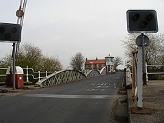
Cawood Bridge is a swing bridge which spans the Yorkshire River Ouse in North Yorkshire, England. Construction was authorized in 1870, with the formation of the Cawood Bridge bridge company.[1] It was opened on 31 July 1872 to replace the ferry, and is located about halfway between Naburn and Selby. It is the only bridge from the village of Cawood that crosses the river. It is Grade II listed.[2]
Operations[]
The bridge, whose maintenance is the responsibility of North Yorkshire County Council, has a weight limit of 10 tonnes. CCTV cameras are installed to monitor traffic not adhering to the weight limit or red lights, and to allow officials to see traffic in both directions. It is the policy of the county council to prosecute any overweight vehicle, or vehicle jumping the red lights, caught on CCTV. Previous fines have been as much as £900. Crossing vehicles used to be charged a toll, but this system has since[when?] been scrapped.
The bridge has experienced numerous problems in the past[when?], due partly to its age, but mainly due to the increasing numbers of heavy goods vehicles and heavily laden farm vehicles which ignore the weight limit on the bridge. Issues have included the locking pin falling out of place, cracks forming in the supporting structure, and jamming of the swing mechanism, which has caused heavy traffic delays and tailbacks.
2003 closure[]
In October 2003, the bridge was closed for five days for urgent repair work, after a vehicle collided with a safety barrier.
Later inspection discovered that the York end of the bridge was about to fail due to three large cracks in one of the supporting steel plates, which ran the full length of the bridge. River traffic was halted, and new plates were fitted within hours, as a temporary measure.
Permanent repairs involved a steel plate, twice the thickness of the original, being fitted along the entire deck.
2015 floods[]
In late December 2015, heavy rainfall led to flooding across large parts of northern England and Wales. The Ouse at Cawood flowed over the deck of the bridge.[3]
References[]
- ^ Lords (1870). THE HOUSE OF LORDS SESSION 1870. Oxford University. p. 181.
- ^ Historic England. "Cawood Bridge (1316656)". National Heritage List for England. Retrieved 15 June 2015.
- ^ "Flooding near Cawood stretches over a mile". ITV News. 27 December 2015. Retrieved 27 December 2015.
- Bridges in North Yorkshire
- Bridges completed in 1872
- Swing bridges in England
- Bridges across the River Ouse, Yorkshire
- Former toll bridges in England
- Grade II listed bridges
- Grade II listed buildings in North Yorkshire