Central District, Seattle
Central District, Seattle | |
|---|---|
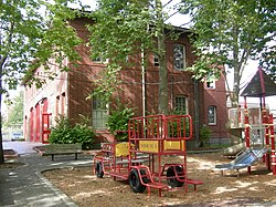 Firehouse Mini Park and the Cherry Hill Community Center: the former Firehouse No. 23, headquarters of the Central Area Motivation Program. The building is on the National Register of Historic Places. | |
| Nicknames: Central Area, CD | |
 Central District Highlighted in Pink | |
| Coordinates: 47°36′31″N 122°17′46″W / 47.60861°N 122.29611°WCoordinates: 47°36′31″N 122°17′46″W / 47.60861°N 122.29611°W | |
| Country | United States |
| State | Washington |
| County | King |
| City | Seattle |
| Zip Code | 98122 |
| Area Code | 206 |

The Central Area, commonly called the Central District or The CD,[1] is a mostly residential district in Seattle located east of downtown and First Hill (12th Avenue and Rainier Avenue); west of Madrona, Leschi and Mt. Baker; south of Capitol Hill, and north of Rainier Valley. Historically, the Central District has been one of Seattle's most racially and ethnically diverse neighborhoods,[2] and was once the center of Seattle's black community and a major hub of African-American businesses.[3]
History & Demographics[]
The culture and demographics of the Central District have changed repeatedly throughout many years. It started out as a predominantly Jewish neighborhood.[4] Jewish residents built Temple De Hirsch on Union Street in 1907;[1] Temple De Hirsch Sinai on the opposite corner of the same block is a successor to that congregation; the original Temple De Hirsch is largely demolished, though some fragments remain. Other former synagogues in the neighborhood are the former Sephardic Bikur Holim synagogue (now Tolliver Temple), Herzl Congregation synagogue (now Odessa Brown Clinic), and Chevra Bikur Cholim (now Langston Hughes Performing Arts Center).
A few decades later, the Central District became a home to Japanese-Americans in Seattle. The blocks between 14th and 18th Avenues and Yesler Way and Jackson Street still retain a strong Japanese presence—the Buddhist Church, Seattle Koyasan Church, Konko, Wisteria Park, Japanese Congregational Church, Keiro Nursing Home, and the Kawabe Memorial House. During World War II, presidential Executive Order 9066 made possible the removal of American citizens of Japanese descent from the West Coast. All Japanese residents were immediately taken out of their homes and sent to internment camps. This and many race-restricted covenants to the north and south paved the way for many African Americans to find a new home in the Central District as part of the Second Great Migration to the city in search of employment opportunities in the munitions plants during the war as well as taking advantage of the post-war economic expansion.[5] By the 1970s, Central District became largely an African-American neighborhood and the center of the civil rights movement in Seattle. In 1970, Blacks made up nearly 80% of the neighborhood's population.[6] However, it also marked the neighborhood's decline into poverty and crime for another two decades.
In the early 21st century, several demographic trends are changing the population of the Central District again. Low-income segments of the population are moving southward toward the Rainier Valley, while more affluent residents, who might otherwise have purchased homes on Capitol Hill, Madrona, Leschi, or Mt. Baker are moving into the Central District as real estate and rental property become more expensive in the former neighborhoods and commuting times and costs make suburban areas less attractive.[7]
Due to this market pressure, housing in the Central District is mixed, with some homes on the verge of condemnation, and others having recently undergone extensive renovation. Many condemned houses are being replaced by multi-unit townhouses and condominiums. Easy access to Interstate 5, Interstate 90, and Downtown, as well as ample street parking, also make the Central District an attractive and convenient place to live.
Despite the demographic shifts since the early 1970s, many locals still think of the Central District as a predominantly African-American area. One reason for this is that despite the decline in the African-American population,[8] there is black history in the neighborhood. It is home to the Northwest African American Museum, The Liberty Bank Building, the historic site of the first black-owned bank in Seattle,[9][10] Medgar Evers Pool, and the Second Headquarters of the Seattle Black Panther Party and The People's Wall.[11]
During the early 1960s, the neighborhood was a hotbed for the Seattle civil rights movement. In 1963, civil rights protesters took to the streets and protested against racial discrimination. Later, they participated in a sit-in in downtown Seattle. At the same time, the Black Panther Party used the neighborhood as a staging area for their movement.
As of 2010 the total population of the Central Area is 29,868 with a population that is 59.6% White or Caucasian, 21.4% Black or African-American, 9.1% Asian, 0.6% Native American, 0.3% Pacific Islander, 3.2% from other races and 6.1% from two or more races. Hispanic or Latino of any race consisted of 7.3% of the population.
Notable residents[]

- Ernestine Anderson
- Linda Emery
- Jimi Hendrix
- Quincy Jones
- Kyle Townsend
- Bruce Lee
- Rose McGowan
- Brandon Roy
- Isaiah Stanback
- Sir Mix-a-Lot
- Kip Tokuda[12]
- NoClue
Transportation[]
The Central District's main thoroughfares includes its east boundary along Martin Luther King Jr. Way ("MLK"), its west boundaries along 12th Avenue and Rainier Avenue, and its 'main street' 23rd Avenue (north and southbound). Major east–west streets in the neighborhood include E. Union, E. Cherry, E. Jefferson, E. Yesler Way, and S. Jackson.[citation needed]
Public transportation[]
King County Metro operates several bus routes in the Central District, including Route 2, Route 3, Route 4, Route 8, Route 11, Route 12, Route 14, Route 27, Route 48.
As part of the East Link Extension, Seattle's Sound Transit is adding a link light rail stop at the south end of the Central District in Judkins Park, (expected opening in 2023).[13]
Public parks and greenspaces[]
The Central District is home to at least 18 public parks, and community green spaces. Notable parks include: T.T. Minor Playground, Firehouse Mini Park, Garfield Playfield, Pratt Park, Dr. Blanche Lavizzo Park, Judkins Park and Playfield, Judkins Skatepark, Jimi Hendrix Park, and Sam Smith Park.
The Central District is home to 4 P-Patch Community Gardens: Immaculate P-Patch at E Columbia St & 18th Ave, Squire Park at 14th Ave & E Fir St, Climbing Water at 800 Hiawatha Pl S, and Judkins at 24th Ave S & S Norman St.
Landmarks and institutions[]
Landmarks and institutions
- Northwest African American Museum
- Bullitt Center
- Langston Hughes Performing Arts Center
- The Nova Project
- Washington Hall
Schools
Restaurants, Bars & Shops
References[]
- ^ Jump up to: a b Mary T. Henry, Seattle Neighborhoods: Central Area -- Thumbnail History, HistoryLink, March 10, 2001. Accessed online 2009-10-19.
- ^ McGee, Henry (2007-08-19). "Gentrification, Integration or Displacement?: The Seattle Story •". Retrieved 2021-05-02.
- ^ "Archived copy". Archived from the original on 2009-07-12. Retrieved 2008-12-28.CS1 maint: archived copy as title (link)
- ^ Seattle Segregation Maps 1920-2000, Seattle Civil Rights & Labor History Project. Accessed online 2009-10-19.
- ^ Racial Restrictive Covenants, Seattle Civil Rights & Labor History Project. Accessed online 2009-10-19.
- ^ [1]
- ^ Sonia Krishnan, City Centered in Seattle Archived December 23, 2008, at the Wayback Machine, Seattle Times Pacific NW Cover Story, November 16, 2008. Accessed online 2009-10-19.
- ^ Seattle Times: "Seattle’s vanishing black community" By Tyrone Beason May 26, 2016
- ^ Pien, Diane (2018-07-02). "Liberty Bank Seattle Washington (1968-1988) and Liberty Bank Building •". Retrieved 2021-05-02.
- ^ "Building upon the legacy of the Central District's Liberty Bank". The Seattle Globalist. 2019-07-23. Retrieved 2021-05-02.
- ^ "HistoryLink Tours — Second Headquarters of the Seattle Black Panther Party and The People's Wall". historylink.tours. Retrieved 2021-05-02.
- ^ Thompson, Lynn (2013-07-15). "Former state legislator Kip Tokuda dies while fishing". Seattle Times. Retrieved 2013-07-16.
- ^ "East Link Extension | Project map and summary | Sound Transit". www.soundtransit.org. Retrieved 2021-05-02.
External links[]
| Wikivoyage has a travel guide for Seattle/Capitol Hill-Central District. |
- Central District News
- 23rdandunion.org, outgrowth of a 2009 KUOW-FM/Hollow Earth Radio documentary project. See also The Corner: 23rd and Union, The Hub, KUOW News, August 26, 2009.
- Seattle Photograph Collection, Central District - University of Washington Digital Collection
- Neighborhoods in Seattle
- Central District, Seattle
- African-American history in Seattle
- Historic Jewish communities in the United States