Central Yakutian Lowland
| Central Yakutian Lowland | |
|---|---|
| Центральноякутская равнина Саха сирин ортоку намтала | |
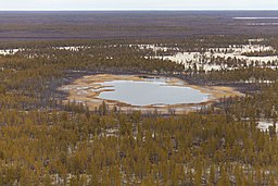 Taiga landscape in Vilyuy District | |
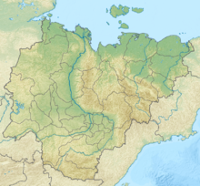 Location in Yakutia, Russia | |
| Location | Sakha Republic, Russia |
| Coordinates | 64°30′N 121°0′E / 64.500°N 121.000°ECoordinates: 64°30′N 121°0′E / 64.500°N 121.000°E |
| Part of | Siberia |
| Elevation | 60 meters (200 ft) to 200 meters (660 ft) |
| Area | 270,000 km2 (100,000 sq mi) |

The Central Yakutian Lowland[1] or Central Yakutian Lowlands (Russian: Центральноякутская равнина; Yakut: Саха сирин ортоку намтала),[2] also known as Central Yakut Plain[3] or Vilyuy Lowland,[4] is a low alluvial plain in Siberia, Russia.
Administratively the territory of the lowland is part of the Sakha Republic (Yakutia). It is an extensive plain located in the transition zone between Central and Eastern Siberia and is one of the Great Russian Regions. The main city is Yakutsk, with a number of settlements near it, but the area of the lowland is largely uninhabited elsewhere.[5]
Geography[]
The Central Yakutian Lowlands extend along the middle basin of the Lena River and partly further downstream and are about 900 kilometres (560 mi) in length and 350 kilometres (220 mi) wide.[6] They drop gradually from the Central Siberian Plateau to the west and the Lena Plateau to the south and southwest. To the northwest the lowland merges with the North Siberian Lowland and to the north it is bound by the watershed fringing the Lena and Olenyok River basins, and to the northeast and east the Central Yakutian Lowland reaches the foothills of the Verkhoyansk Range, westernmost part of the East Siberian Mountains.[7]
There are hundreds of river valleys all across the lowlands, which, besides the Lena, include the lower reaches of the Lena tributaries Vilyuy, Amga and Aldan. The rivers of the lowland are subject to spring floods during the thaw period and occasional rain floods in the summer. During the winter small rivers and rivulets freeze to the bottom.[7]
The Central Yakutian Lowlands are a flat plain, slightly higher in its peripheral parts. Permafrost is continuous throughout the region. Swamps and thermokarst lakes (alases), are common,[8] as well as low bulges or bumps known as "bulgunnyakh" (Yakut: Булгунньах).[9] The largest lake of the lowland is Nedzheli. In the northwest the Tukulan (Тукуланы) sand dunes are relief forms shaped by aeolian processes along the valley of the Lena River.[10] There are also some areas of high soil salinity.[7]
 German map of the Russian geomorphological regions. |
 View of the lowland taiga. |
Geology[]
Geologically the lowland roughly corresponds to the eastern, lowest parts of the Vilyuy Syneclise. It is filled with Mesozoic deposits and Quaternary sands and loams, both of alluvial and eolian origin.[1]
Climate and flora[]
The climate prevailing in the lowland is continental and harsh, characterized by a very low annual rainfall of barely 300 millimetres (12 in) per year. 70% to 80% of the precipitation falls in the summer, mostly in the form of rain. The average air temperature in January is a chilly −45 °C (−49 °F). In July the average temperature is 17 °C (63 °F).[7]
Most of the lowland is covered by taiga in which larch predominates. There are as well areas of birch forests, marshes and grassy meadows.[7]
See also[]
References[]
- ^ a b John Kimble (ed.), Cryosols: Permafrost-Affected Soils
- ^ Physical and Chemical Characteristics of Lakes in the Central Yakutian Lowlands, Russia
- ^ Siberian Village; Land and Life in the Sakha Republic
- ^ United States Bureau of Commercial Fisheries, Fishery and Oceanography Translations, Issues 1-6, p. 48
- ^ Google Earth
- ^ Solov'ev, P. A., 1959, Permafrost zones of the northern part of the Lena-Amga Water-shed: Moscow, Nauka. (in Russian)
- ^ a b c d e Central Yakutian Lowland - Great Soviet Encyclopedia, Vol. 28, p. 513
- ^ Permafrost dynamics in the 20th and 21st centuries along the East Siberian transect
- ^ Russian scientists find 7,000 Siberian hills possibly filled with explosive gas
- ^ Tukulan - The Yakut Desert
External links[]
 Media related to Central Yakutian Lowland at Wikimedia Commons
- Limnological characteristics of lakes in the lowlands of Central Yakutia, Russia
This Sakha Republic location article is a stub. You can help Wikipedia by . |
- Sakha Republic geography stubs
- Central Yakutian Lowland