Ceru-Băcăinți
Ceru-Băcăinți | |
|---|---|
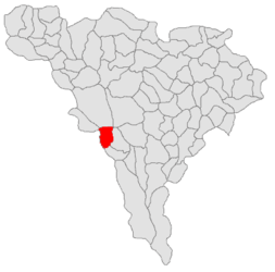 Location in Alba County | |
 Ceru-Băcăinți Location in Romania | |
| Coordinates: 45°59′N 23°15′E / 45.983°N 23.250°ECoordinates: 45°59′N 23°15′E / 45.983°N 23.250°E | |
| Country | Romania |
| County | Alba |
| Government | |
| • Mayor (2020–2024) | Ioan Trif (PMP) |
| Area | 49.5 km2 (19.1 sq mi) |
| Elevation | 405 m (1,329 ft) |
| Population (2011)[1] | 269 |
| • Density | 5.4/km2 (14/sq mi) |
| Time zone | EET/EEST (UTC+2/+3) |
| Vehicle reg. | AB |
| Website | cerubacainti |

Ceru-Băcăinți (German: Bocksdorf; Hungarian: Bokajfelfalu) is a commune located in Alba County, Transylvania, Romania. It has a population of 376 and is composed of ten villages: Bolovănești, Bulbuc (Bulbuk), Ceru-Băcăinți, Cucuta, Curpeni (Kurpény), Dumbrăvița, Fântânele, Groși, Valea Mare (Váleamáre) and Viezuri (Gyézuri házcsoport).
The commune is situated in the western part of the county, on the border with Hunedoara County. It lies in the southwestern part of the Metaliferi Mountains; with an altitude of 860 m (2,820 ft), the Piatra Tomii peak dominates Bulbuc village.[2]
References[]
- ^ "Populaţia stabilă pe judeţe, municipii, oraşe şi localităti componenete la RPL_2011" (in Romanian). National Institute of Statistics. Retrieved 4 February 2014.
- ^ "Cadrul Natural". cerubacainti.ro (in Romanian). Ceru-Băcăinți townhall. Retrieved July 21, 2021.
This Alba County location article is a stub. You can help Wikipedia by . |
Categories:
- Communes in Alba County
- Localities in Transylvania
- Alba County geography stubs