Chüemettler
| Chüemettler | |
|---|---|
 | |
| Highest point | |
| Elevation | 1,703 m (5,587 ft) |
| Prominence | 99 m (325 ft)[1] |
| Parent peak | Speer and Federispitz |
| Isolation | 0.68 km (0.42 mi) |
| Coordinates | 47°10′47″N 9°5′46″E / 47.17972°N 9.09611°ECoordinates: 47°10′47″N 9°5′46″E / 47.17972°N 9.09611°E |
| Geography | |
| Location | St. Gallen, Switzerland |
| Parent range | Appenzell Alps |

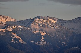
The Chüemettler (1,703 metres (5,587 ft)) is a mountain of the Appenzell Alps, overlooking the Walensee in the canton of St. Gallen. It lies south of the Speer and southeast of the Federispitz mountains. Chüe literally means cows in Swiss-German language, Mettler is a family name respectively a term used as name of several local areas.
References[]
External links[]
| Wikimedia Commons has media related to Chüemettler. |
This Canton of St. Gallen location article is a stub. You can help Wikipedia by . |
Categories:
- Mountains of Switzerland
- Mountains of the canton of St. Gallen
- Mountains of the Alps
- Appenzell Alps
- Canton of St. Gallen geography stubs