Walensee
| Walensee Lake Walen Lake Walenstadt | |
|---|---|
 Walensee and Unterterzen, Quarten | |
 Walensee Lake Walen Lake Walenstadt | |
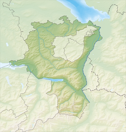
 Map | |
| Location | St. Gallen, Glarus |
| Coordinates | 47°7′N 9°12′E / 47.117°N 9.200°ECoordinates: 47°7′N 9°12′E / 47.117°N 9.200°E |
| Primary inflows | Linth (), Seez, |
| Primary outflows | Linth canal |
| Basin countries | Switzerland |
| Surface area | 24.19 km2 (9.34 sq mi) |
| Average depth | 104.7 m (344 ft) |
| Max. depth | 151 m (495 ft) |
| Water volume | 2.5 km3 (2,000,000 acre⋅ft) |
| Residence time | 1.4258 years |
| Surface elevation | 419 m (1,375 ft) |
| Islands | Schnittlauchinsel |
| Settlements | Walenstadt, Weesen, Quinten, Quarten, Murg |

The Walensee, also known as Lake Walen or Lake Walenstadt from Walenstadt, is one of the larger lakes in Switzerland, with about two thirds of its area in the Canton of St. Gallen and about one third in the Canton of Glarus. Other towns and villages at the lake include Weesen, Quinten, Quarten, and Murg.
The three main rivers leading to the lake are the Seez, , and Linth. The last continues its course from Walensee to Lake Zurich. The Schnittlauchinsel, at the eastern end of the lake, is the only island in the Walensee.
The Churfirsten range raises steeply on the north side from the lake's level at 419 m to 2,306 m above sea level. On the south, the lake is overlooked by the Mürtschenstock Massif, whose peak is 2,441 m above sea level. The highest point of the lake's drainage basin is the Tödi (3,614 m).[1]
The lake provided the inspiration for a solo piano piece by Hungarian Romantic composer Franz Liszt, Au lac de Wallenstadt. The piece is part of a collection of solo piano works inspired by his travels to Switzerland in the 1830s.

Gallery[]
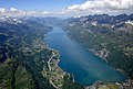
Aerial image of the Walensee

Looking to the west towards Amden


References[]
- ^ 1:25,000 topographic map (Map). Swisstopo. Retrieved 2014-07-30.
External links[]
 Media related to Walensee at Wikimedia Commons
- Waterlevels of Walensee at Murg
| show Lakes of Switzerland |
|---|

| show Authority control |
|---|
- Walensee
- Lakes of Switzerland
- Lakes of the canton of Glarus
- Lakes of the canton of St. Gallen
- Linth/Limmat basin
- Glarus–St. Gallen border