
Chanakyapuri
Chanakyapuri | |
|---|---|
Sub-Division | |
 Chanakyapuri Location in Delhi, India | |
| Coordinates: 28°35′30″N 77°10′19″E / 28.59153°N 77.171895°E | |
| Country | |
| State | Delhi |
| District | New Delhi |
| Government | |
| • Body | New Delhi Municipal Council |
| • Member of Parliament | Meenakshi Lekhi |
| Area | |
| • Total | 6.085 km2 (2.349 sq mi) |
| Elevation | 236.67 m (776.48 ft) |
| Languages | |
| • Official | Hindi, English |
| Time zone | UTC+5:30 (IST) |
| PIN | 110021 |
| Lok Sabha constituency | New Delhi |
| Civic agency | NDMC |
Chanakyapuri (IAST: Cāṅakyapurī ) is a neighbourhood and diplomatic enclave established in the 1950s in New Delhi.[1][2][3] It is also a sub-division of the New Delhi district and plays host to the majority of foreign embassies in New Delhi. Chanakyapuri, meaning "city of Chanakya", is named after Chanakya, a third-century BC advisor to Chandragupta Maurya.
History[]
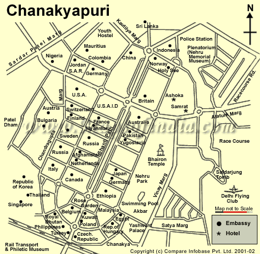
Chanakyapuri was the first major extension of New Delhi beyond Lutyens' Delhi. The Central Public Works Department (CPWD) developed a large area of land acquired from a Gurjar village that was located there to create this diplomatic enclave in the 1950s. Subsequently, this land was allotted to embassies, chanceries, high commissions and ambassador residences. The enclave is built around a wide central vista, known as Shanti Path (Peace Road), with wide green areas. A large landscaped park spread over an area of 80 acres, known as Nehru Park, was developed in 1969 for the families of the diplomatic personnel. In time, two markets, two colleges and schools run by diplomatic missions (including The British School and the American Embassy School) were established in the neighbourhood.[4]
Accessibility[]
Major roads in Chanakyapuri include Shanti Path, Nyaya Marg, Niti Marg, Chandragupta Marg and Panchsheel Marg. In addition to these, the Ring Road traverses the southern expanse of the neighbourhood and intersects National Highway 8 on the border with neighbouring Dhaula Kuan. Sardar Patel Marg marks the Western periphery, while the Chanakya Cinema complex, which lies beyond Nehru Park, forms the south-western perimeter. The Delhi Ring Railway stops at Chanakyapuri, while Lok Kalyan Marg metro station and Jor Bagh metro station are the nearest stations of Delhi Metro.
Education[]
Primary and secondary schools[]
- The , for expatriates from the US and other countries.
- The British School offers the British National Curriculum, the IGCSE and IB. It primarily serves the international community
- German School New Delhi[5]
- Russian Embassy School in Delhi[6]
- Sanskriti School, a renowned education institution, which mainly serves the children of civil servants.
- Navy Children School which mainly serves the children of Naval background.
Universities[]
- Jesus and Mary College, a constituent college of the University of Delhi.
- Maitreyi College, another constituent college of the University of Delhi.
- South Asian University, an international university established by the SAARC.
See also[]
- Ministry of External Affairs of India
- Areas And Zones of New Delhi
- Lutyens' Delhi
References[]
- ^ PTI (14 August 2015). "Dwarka diplomatic enclave to be modelled on Shanti Path". The Economic Times. Retrieved 1 July 2018.
- ^ What Lies Inside Delhi's Diplomatic Enclaves?
- ^ Delhi’s Belly - Secret republics
- ^ Viswambhar Nath (2007). "Delhi Before 1947". Urbanization, urban development, and metropolitan cities in India. Concept Publishing Company. p. 248. ISBN 978-81-8069-412-7.
- ^ "Contact." German School New Delhi. Retrieved on 11 February 2015. "2, Nyaya Marg, Chanakyapuri New Delhi 110 021 India" - Also listed as: "Block F, Diplomatic Enclave, Chanakyapuri"
- ^ "Сведения о школе." (Archive). Russian Embassy School in New Delhi. Retrieved on 18 April 2015. "PLOT G BLOK 50E NYAYA MARG, CHANAKYAPURI, NEW-DELHI -110021, INDIA"
External links[]
- http://www.markestates.co.in/where_cat_detail.php?id=1585
- Map of Chanakyapuri
- Chanakyapuri at Google Maps
- Neighbourhoods in Delhi
- District subdivisions of Delhi
- Diplomatic districts
- New Delhi district
- Cities and towns in New Delhi district
- 1950s establishments in Delhi