Charida
Charida | |
|---|---|
Village | |
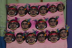 Masks at Charida | |
 Charida Location in West Bengal, India | |
| Coordinates: 23°12′17″N 86°01′53″E / 23.2046°N 86.0314°ECoordinates: 23°12′17″N 86°01′53″E / 23.2046°N 86.0314°E | |
| Country | |
| State | West Bengal |
| District | Purulia |
| Population (2011) | |
| • Total | 2,568 |
| Languages | |
| • Official | Bengali, English |
| Time zone | UTC+5:30 (IST) |
| PIN | 723152 |
| Telephone/STD code | 03254 |
| Lok Sabha constituency | Purulia |
| Vidhan Sabha constituency | Baghmundi |
| Website | purulia |

Charida (also referred to as Chorida, Chorda) is a village in the Baghmundi CD block in the Jhalda subdivision of the Purulia district in the state of West Bengal, India.
Geography[]
M: municipality, CT: census town, R: rural/ urban centre, H: historical/ religious centre, C: craft centre, T: tourist cetre
Owing to space constraints in the small map, the actual locations in a larger map may vary slightly
Location[]
Charida is located at 23°12′17″N 86°01′53″E / 23.2046°N 86.0314°E.
Charida is about 5 km from Baghmundi village, at the scenic foothills of the Ajodhya Hills.[1][2]
Area overview[]
Purulia district forms the lowest step of the Chota Nagpur Plateau. The general scenario is undulating land with scattered hills. Jhalda subdivision, shown in the map alongside, is located in the western part of the district, bordering Jharkhand. The Subarnarekha flows along a short stretch of its western border. It is an overwhelmingly rural subdivision with 91.02% of the population living in the rural areas and 8.98% living in the urban areas. There are 3 census towns in the subdivision. The map alongside shows some of the tourist attractions in the Ajodhya Hills. The area is home to Purulia Chhau dance with spectacular masks made at Charida. The remnants of old temples and deities are found in the subdivision also, as in other parts of the district.[3][4][5][6][7][8]
Note: The map alongside presents some of the notable locations in the subdivision. All places marked in the map are linked in the larger full screen map.
Demographics[]
According to the 2011 Census of India, Chorda had a total population of 2,568, of which 1,353 (53%) were males and 1,215 (47%) were females. There were 385 persons in the age range of 0-6 years. The total number of literate persons in Chorda was 1,416 (64.86% of the population over 6 years).[9]
Culture[]
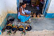
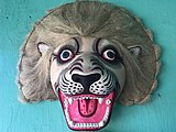
Charida is famous for the Chhau masks used in the Purulia Chhau dance.[1] Around 150 families are involved in mask-making. It involves five elaborate processes and depending on the intricacies involved it takes two to seven days to complete a mask. “The Chhau craft itself dates back 150 years, to the reign of King Madan Mohan Singh Deo of Baghmundi”. A chau mask festival is organised at Charida in January-February. Some of the craftsmen have travelled to far off places such as Japan and France “to showcase their work and popularise Chhau.”[2]
“The Kirat-Kiratin avtar of Shiva and Durga is the inspiration” behind the Chhau mask. Apart from their traditional use in the Purulia chhau dance, the masks have become a drawing room show piece. Traditionally, only people of lower castes were involved in mask making but the growing demand of the item is drawing in people from all castes into this profession.[2]
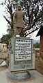
Gambhir Singh Mura, an outstanding Chhau dancer and a Padma Shri awardee, belonged to the nearby village of Pitikiri Bamni. Now, his statue adorns Charida. [2]
Charida picture gallery[]
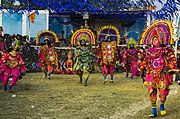
Chhau performance
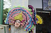
A chhau mask
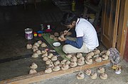
The preliminary stage of mask-making
The advanced stage of mask making

Providing finishing touches

An artist at work

Masks on sale

Charida mask
Charida mask
Statue of Gambhir Singh Mura


References[]
- ^ a b "District Census Handbook: Puruliya – Series 20, Part Xii A, Census of India 2011" (PDF). Page 102: Brief Description of Places of Religious, Historical or Archaeological Importance and Places of Tourist Interest of the District. Directorate of Census Operations, West Bengal. Retrieved 28 January 2020.
- ^ a b c d Banerjee, Tania. "Charida, the village of mask makers". The Hindu, 9 June 2018. Retrieved 28 January 2020.
- ^ Houlton, Sir John, Bihar, the Heart of India, 1949, p. 170, Orient Longmans Ltd.
- ^ "District Statistical Handbook 2014 Purulia". Tables 2.1, 2.2. Department of Planning and Statistics, Government of West Bengal. Retrieved 12 January 2020.
- ^ "Purulia". Department of Tourism. Government of West Bengal. Retrieved 1 February 2020.
- ^ "Chhau dance of Purulia". Itsavpedia. Retrieved 1 February 2020.
- ^ "District Census Handbook: Puruliya – Series 20, Part Xii A, Census of India 2011" (PDF). Page 102: Brief Description of Places of Religious, Historical or Archaeological Importance and Places of Tourist Interest of the District. Directorate of Census Operations, West Bengal. Retrieved 28 January 2020.
- ^ "Deuli, Harup and Suisa, Crumbling Temples, Scattered Statues and Single Room Museum". Rangan Dutta/ Wordpress. Retrieved 21 January 2020.
- ^ "C.D. Block Wise Primary Census Abstract Data(PCA)". West Bengal – District-wise CD Blocks. Registrar General and Census Commissioner, India. Retrieved 28 January 2020.
External links[]
| Wikimedia Commons has media related to Charida. |
| Cities, municipal and census towns |
|  Divisions of West Bengal | ||||||||
|---|---|---|---|---|---|---|---|---|---|---|
| Locations other than cities and towns |
| |||||||||
| Related topics |
| |||||||||
- Villages in Purulia district