Chicken Historic District
Chicken Historic District | |
Alaska Heritage Resources Survey
| |
 | |
 | |
| Location | Mile 66.5 of Taylor Highway |
|---|---|
| Nearest city | Chicken, Alaska |
| Coordinates | 64°04′29″N 141°55′56″W / 64.07475°N 141.93233°WCoordinates: 64°04′29″N 141°55′56″W / 64.07475°N 141.93233°W |
| Area | 3 acres (1.2 ha) |
| Built | 1908 |
| NRHP reference No. | 01001053[1] |
| AHRS No. | EAG-00008 |
| Added to NRHP | September 30, 2001 |

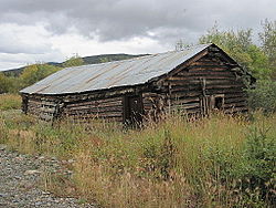
The Chicken Historic District encompasses part of the historic mining district of Chicken, Alaska. It is located at milepost 66.5 on the north side of the Taylor Highway, and includes fifteen buildings built between 1908 and 1967. Most of these are single-story wood-frame structures, with either metal or board-and-batten siding, although there are also some log structures. Many of these buildings were erected by the Fairbanks Exploration Company, which ran the gold mining operations in the area. Notable buildings include the bunkhouse, a gabled log structure, and the Chicken Creek Roadhouse, built in 1906, which was originally two stories in height but was reduced to a single story in 1924. The district also includes a section of water pipeline built by the company to bring water to the area from Mosquito Creek, a distance of about 1 mile (1.6 km). The camp was used until the company ended mining operations in 1967.[2]
The district was listed on the National Register of Historic Places in 2001.[1]
See also[]
References[]
- ^ a b "National Register Information System". National Register of Historic Places. National Park Service. July 9, 2010.
- ^ "NRHP nomination for Chicken Historic District". National Park Service. Retrieved 2014-12-03.
| Wikimedia Commons has media related to Chicken Historic District. |
Boroughs |  | ||
Census areas | |||
There are no sites listed on the National Register of Historic Places in Kusilvak Census Area. | |||
| Topics | |
|---|---|
| Lists by state |
|
| Lists by insular areas | |
| Lists by associated state | |
| Other areas | |
| Related | |
| |
This article about a property in Alaska on the National Register of Historic Places is a stub. You can help Wikipedia by . |
This article about a location in the Southeast Fairbanks Census Area, Alaska is a stub. You can help Wikipedia by . |
This article about mining is a stub. You can help Wikipedia by . |
- Buildings and structures completed in 1908
- Gold mining in Alaska
- Historic districts on the National Register of Historic Places in Alaska
- National Register of Historic Places in Southeast Fairbanks Census Area, Alaska
- 1908 establishments in Alaska
- Alaska Registered Historic Place stubs
- Alaska geography stubs
- Mining stubs