Chilbolton
| Chilbolton | |
|---|---|
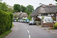 Village street, Chilbolton | |
 Chilbolton Location within Hampshire | |
| Population | 1,010 [1] 988 (2011 Census)[2] |
| OS grid reference | SU392399 |
| Civil parish |
|
| District | |
| Shire county | |
| Region | |
| Country | England |
| Sovereign state | United Kingdom |
| Post town | Stockbridge |
| Postcode district | SO20 |
| Dialling code | 01264 |
| Police | Hampshire |
| Fire | Hampshire and Isle of Wight |
| Ambulance | South Central |
| UK Parliament |
|

Chilbolton is a village and civil parish in Hampshire, England, near to Stockbridge. It is situated 18 miles (29 km) north of Southampton and four miles (6.4 km) south of Andover. Its most notable feature is the Chilbolton Observatory situated on the disused RAF Chilbolton airfield. The parish church of St Mary the Less dates back to the 12th century, on the site of an earlier wooden church. The River Test runs through Chilbolton Common.
Chilbolton is recorded in the Domesday Book under the name Cilbodentune.
See also[]
References[]
- ^ "Parish Headcounts, Area: Chilbolton CP". Neighbourhood Statistics. Office for National Statistics. 2001. Retrieved 27 February 2008.[permanent dead link]
- ^ "Civil Parish population 2011". Neighbourhood Statistics. Office for Natiuonal Statistics. Retrieved 12 December 2016.
External links[]
| Wikimedia Commons has media related to Chilbolton. |
- Chilbolton and Wherwell Website
- ANY-village for Chilbolton[permanent dead link]
- Publications featuring Chilbolton
- The Abbots Mitre Chilbolton and Cottonworth Trail

This Hampshire location article is a stub. You can help Wikipedia by . |
Categories:
- Villages in Hampshire
- Test Valley
- Hampshire geography stubs